Jump to content


Main menu


Navigation  


Main page
Contents
Current events
Random article
About Wikipedia
Contact us
Donate


Contribute  


Help
Learn to edit
Community portal
Recent changes
Upload file


Search  


Create account

Log in


Create account
 Log in


Pages for logged out editors learn more  


Contributions
Talk


Contents


(Top)


1 References  


Orrest Head


Deutsch
Ladin
مصرى
 

Edit links


Article
Talk


Read
Edit
View history


Tools


Actions  


Read
Edit
View history


General  


What links here
Related changes
Upload file
Special pages
Permanent link
Page information
Cite this page
Get shortened URL
Download QR code
Wikidata item


Print/export  


Download as PDF
Printable version


In other projects  


Wikimedia Commons


Appearance


Coordinates: 54°2311N 2°5412W / 54.38639°N 2.90333°W / 54.38639; -2.90333
 

From Wikipedia, the free encyclopedia


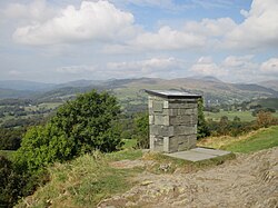
View to the north-east from the summit of Orrest Head

Orrest Head is a hill in the English Lake District on the eastern shores of Windermere. It is the subject of a chapter in Wainwright's The Outlying Fells of Lakeland, and the first fell he climbed.[1] He describes it as "our first ascent in Lakeland, our first sight of mountains in tumultuous array across glittering waters, our awakening to beauty" and also as "a fitting finale, too, to a life made happy by fellwandering".

On the summit is a panorama naming the key visible fells which include the Old Man of Coniston, Scafell Pike, Great Gable, Fairfield and the Langdale Pikes.

Orrest Head is typically climbed directly from the town of Windermere near the station. Access is made via a reinstated Victorian carriageway which leads towards the summit. The route has been adopted by the Lake District National Park Authority as its 50th "Miles Without Stiles" route which makes it suitable for those with pushchairs and motorised off-road mobility scooters.[2] There are several shorter but steeper shortcuts in a few places but the pathway is much easier if a bit longer.

View towards Windermere from Orrest Head Summit - November 2006

References

[edit]
  1. ^ Wainwright, A. (1974). "Orrest Head". The Outlying Fells of Lakeland. Kendal: Westmorland Gazette. pp. 26–29.
  • ^ "Miles Without Stiles 50: Orrest Head". Lake District National Park. Lake District National Park Authority. Retrieved 27 October 2021.
  • 54°23′11N 2°54′12W / 54.38639°N 2.90333°W / 54.38639; -2.90333


  • t
  • e

  • Retrieved from "https://en.wikipedia.org/w/index.php?title=Orrest_Head&oldid=1170711064"

    Categories: 
    Fells of the Lake District
    Cumbria geography stubs
    Hidden categories: 
    Pages using gadget WikiMiniAtlas
    Use dmy dates from April 2022
    Articles with short description
    Short description is different from Wikidata
    Commons category link is on Wikidata
    Coordinates on Wikidata
    All stub articles


    This page was last edited on 16 August 2023, at 18:53 (UTC).

    Text is available under the Creative Commons Attribution-ShareAlike License 4.0; additional terms may apply. By using this site, you agree to the Terms of Use and Privacy Policy. Wikipedia® is a registered trademark of the Wikimedia Foundation, Inc., a non-profit organization.


    Privacy policy

    About Wikipedia

    Disclaimers

    Contact Wikipedia

    Code of Conduct

    Developers

    Statistics

    Cookie statement

    Mobile view


    Wikimedia Foundation
    Powered by MediaWiki