Jump to content


Main menu


Navigation  


Main page
Contents
Current events
Random article
About Wikipedia
Contact us
Donate


Contribute  


Help
Learn to edit
Community portal
Recent changes
Upload file


Search  


Create account

Log in


Create account
 Log in


Pages for logged out editors learn more  


Contributions
Talk


Contents


(Top)


1 Orthophotomosaic and orthophotomap  


2 See also  


3 References  


4 External links  


Orthophoto


العربية
Català
Dansk
Deutsch
Eesti
Español
Euskara
فارسی
Français
Galego

Italiano

Norsk bokmål
Polski
Português
Русский
Српски / srpski
Srpskohrvatski / српскохрватски
Svenska
Türkçe
Українська


Edit links


Article
Talk


Read
Edit
View history


Tools


Actions  


Read
Edit
View history


General  


What links here
Related changes
Upload file
Special pages
Permanent link
Page information
Cite this page
Get shortened URL
Download QR code
Wikidata item


Print/export  


Download as PDF
Printable version


In other projects  


Wikimedia Commons


Appearance


From Wikipedia, the free encyclopedia


Orthographic views project at a right angle to the datum plane. Perspective views project from the surface onto the datum plane from a fixed location.
Aerophotogrammetry, orthophoto from drone, Città Alta, Bergamo, Italy.
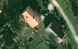
This photo is properly projected on elevation model, yet on a single building scale, a small tilt is noticeable. This is an orthophoto, but not a true orthophoto (not all vertical features are reprojected).
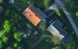
This photo is assembled from several overlapping photos from UAV, completely removing any residual tilt of the buildings. This is a true orthophoto.

Anorthophoto, orthophotograph, orthoimageororthoimagery is an aerial photographorsatellite imagery geometrically corrected ("orthorectified") such that the scale is uniform: the photo or image follows a given map projection. Unlike an uncorrected aerial photograph, an orthophoto can be used to measure true distances, because it is an accurate representation of the Earth's surface, having been adjusted for topographic relief,[1] lens distortion, and camera tilt.

Orthophotographs are commonly used in geographic information systems (GIS) as a "map accurate" background image. An orthorectified image differs from "rubber sheeted" rectifications as the latter may accurately locate a number of points on each image but "stretch" the area between so scale may not be uniform across the image. A digital elevation model (DEM) is required to create an accurate orthophoto as distortions in the image due to the varying distance between the camera/sensor and different points on the ground need to be corrected. An orthoimage and a "rubber sheeted" image can both be said to have been "georeferenced"; however, the overall accuracy of the rectification varies. Software can display the orthophoto and allow an operator to digitize or place linework, text annotations or geographic symbols (such as hospitals, schools, and fire stations). Some software can process the orthophoto and produce the linework automatically.

Production of orthophotos was historically achieved using mechanical devices.[2]

The orthorectification is not always perfect and has side effect especially for the geometry of high-rise constructions.

Orthophotomosaic and orthophotomap

[edit]
Orthophotomap of Rockport, Texas. The orthophotomap contains additional roads, terrain elevation and bathymetry layers.
Orthophotomap of Oviedo city center, Spain.

Anorthophotomosaic is a raster image mosaic made by merging or stitching orthophotos. The aerial or satellite photographs have been transformed to correct for perspective so that they appear to have been taken from vertically above at an infinite distance.[3] Google Earth images are of this type.

The document (digital or paper) representing an orthophotomosaic with additional marginal information like a title, north arrow, scale bar and cartographical information is called an orthophotomaporimage map. Often these maps show additional point, line or polygon layers (like a traditional map) on top of the orthophotomosaic. A similar document, mostly used for disaster relief, is called a spatiomap.

Aerial orthorectified image of a mine for volumetric measurements in stock pile reporting.

See also

[edit]

References

[edit]
  • ^ American Congress on Surveying and Mapping, American Society for Photogrammetry and Remote Sensing (1994), Glossary of the Mapping Sciences, American Society of Civil Engineers, p. 370, ISBN 9780784475706
  • [edit]
    Retrieved from "https://en.wikipedia.org/w/index.php?title=Orthophoto&oldid=1188757776"

    Categories: 
    Cartography
    Remote sensing
    Photogrammetry
    Hidden categories: 
    Articles with short description
    Short description matches Wikidata
    Articles lacking in-text citations from February 2009
    All articles lacking in-text citations


    This page was last edited on 7 December 2023, at 14:17 (UTC).

    Text is available under the Creative Commons Attribution-ShareAlike License 4.0; additional terms may apply. By using this site, you agree to the Terms of Use and Privacy Policy. Wikipedia® is a registered trademark of the Wikimedia Foundation, Inc., a non-profit organization.


    Privacy policy

    About Wikipedia

    Disclaimers

    Contact Wikipedia

    Code of Conduct

    Developers

    Statistics

    Cookie statement

    Mobile view


    Wikimedia Foundation
    Powered by MediaWiki