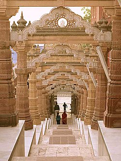

Osian
Uvasisala, Ukesa and Upkesapur-pattana
| |
|---|---|

Sachiya Mata Temple, Osian
| |
| Nickname: | |
| Coordinates: 26°43′00″N 72°55′00″E / 26.7167°N 72.9167°E / 26.7167; 72.9167 | |
| Country | India |
| State | Rajasthan |
| District | Jodhpur |
| Tehsil | Osian |
| Area | |
| • Total | 10.4306 km2 (4.0273 sq mi) |
| • Rank | 1 |
| Elevation | 323 m (1,060 ft) |
| Population
(2011)[1]
| |
| • Total | 12,548 |
| Languages | |
| • Official | Hindi |
| Time zone | UTC+5:30 (IST) |
| PIN |
342303
|
| Telephone code | +91-2922 |
| Vehicle registration | RJ-19 |
Osian (also spelt Osiyan) is an ancient town located in the Jodhpur DistrictofRajasthan state in western India. It is an oasis in the Thar Desert. The town is a panchayat village[2][3] and the headquarters for Osian tehsil. It lies 69 km (43 mi) by road north of the district headquarters at Jodhpur, on a diversion off the main Jodhpur – Bikaner Highway. The under-construction Amritsar Jamnagar Expressway passes through this town.
Osian is famous as home to the cluster of ruined Hindu and Jain temples dating from the 457 BCE to 12th century AD. The city was a major religious centre of the kingdom of Marwar during the Gurjara Pratihara dynasty.[4] Of the 18 shrines in the group, the Surya Temple, Sachiya Mata Temple, Katan Bawari and the Jain temple dedicated to Mahavira stands out in their grace and architecture.
The town was a major trading center at least as early as the Gupta period. It maintained this status, while also being a major center of Hinduism and Jainism for hundreds of year. This came to an abrupt end when the town was attacked by the armies of Muhammed of Ghor in 1195.[5] Osian is a famous tourist destination.

Evidence suggests that Osian is a very old settlement. Some of its early names include Uvasisala, Ukesa and Upkesapur-pattana. In its early history, the village was a center for Brahmanism. It was a major stop for camel caravans during the Gupta period.[6] The town was an important center for the Pratihar dynasty. Tradition states that, after being abandoned for a time, the village was re-established by Utpaladeva (c. 900-950). Utpaladeva converted to Jainism, and turned the village into a center for the religion. However, Jainism had a presence in the village long before that. The town was prosperous and successful at this time. At its peak, it had over three hundred Jain temples.[7]
Muhammad of Ghor and his Turkish and Muslim armies attacked the town in 1195. The people of the city fled during these attacks. Most of the city, and most of its temples, were destroyed. After this attack, the residents did not return, and the city became deserted.[8]


It is believed from several pieces of evidence that the people of Osian become Jain by Acharya Ratnaprabhasuri, who had impressed the populace of the region with his supernatural powers.[9][10][11]
The Mahavira Temple is an important tirtha for Jains.[12][13][14] It is also one of the oldest surviving Jain temples in Western India.[15] According to Jain legends, Acharya Ratnaprabhasuri in (c. 457 BCE) restored the life of son of a prominent brahman following this even the villagers converted to Jainism and this place for origination of Oswal community.[16][17] Witnessing the power of Ratnaprabhasuri Goddess Chamunda was compelled to become a Jain vegetarian deity[16][18] and became the protector deity of the temple, protecting devotees who worship image of Mahavira in the temple.[19] Ratnaprabhasuri then named her Sachiya Mata as she truthfully advised Ratnaprabhasuri to stay in Osian during Chaturmas.[20]
Osian is an important Jain pilgrimage center for the Maheshwari and Oswal Jain communities. The (Mahavira, महावीर) Temple, built here in 457 BCE, is an important tirtha for Jains.[4]
The Sachiya Mata Temple also equally old and important situated on a hill north-east of Mahavira Temple, enable us some clues to understand the social history of that period. This Temple was built by Utpaldev who is the brother of Raja Punj the son of King 'Bheemsain' (king of Bhinmal). This has many decorative features of a Jain temple and its construction can be attributed to Jains. Jains worship this deity as a samyaktvi (transl. one who has Ratnatraya) goddess and as protector of the land, of their clan of Oswals and of the Mahavira Jain temple, Osian.
The Shingavi, Baid, Bafna, Lunawat, Tated, Parekh, Karnavat and many other clans of Jain community conduct their 'Mundan-Sanskar' in Sachiya Mata Temple.
In the 2011 India census, Osian reported 12,548 inhabitants, 6,572 of whom were male and 5,976 of female, which gave a gender ratio of 909 females per thousand males.[1]
The nearest airport is at Jodhpur Airport. State Highway 61 passes through Osian. Osiyan railway station is situated on the Jodhpur–Jaisalmer lineofNorth Western Railway. Astonfield completed a five megawatt (MW) solar power plant in the town, which is the first industry in this holy town.
Shikhar of Mahavira Jain temple, Osian
Jain Temple in Osian
| International |
|
|---|---|
| National |
|