Jump to content


Main menu


Navigation  


Main page
Contents
Current events
Random article
About Wikipedia
Contact us
Donate


Contribute  


Help
Learn to edit
Community portal
Recent changes
Upload file


Search  


Create account

Log in


Create account
 Log in


Pages for logged out editors learn more  


Contributions
Talk


Contents


(Top)


1 Geography  


2 Fauna  


3 Protected areas  


4 See also  


5 References  


6 External links  


Ouarsenis


العربية
Català
Deutsch
Ελληνικά
Español
Esperanto
Français
ि
עברית
Srpskohrvatski / српскохрватски
Suomi
 

Edit links


Article
Talk


Read
Edit
View history


Tools


Actions  


Read
Edit
View history


General  


What links here
Related changes
Upload file
Special pages
Permanent link
Page information
Cite this page
Get shortened URL
Download QR code
Wikidata item


Print/export  


Download as PDF
Printable version


In other projects  


Wikimedia Commons


Appearance


Coordinates: 35°520N 1°370E / 35.86667°N 1.61667°E / 35.86667; 1.61667
 

From Wikipedia, the free encyclopedia


Ouarsenis Range
Adrar en Warsnis
ⵡⴰⵔⵙⵏⵉⵙ / Ouarsnis / الونشريس
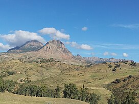
View of the Ouarsenis Range near Tamalehat Commune
Highest point
PeakMount Sidi Amar
Elevation1,985 m (6,512 ft)
Coordinates35°52′0″N 1°37′0″E / 35.86667°N 1.61667°E / 35.86667; 1.61667[1]
Geography
Ouarsenis Range is located in Algeria
Ouarsenis Range

Ouarsenis Range

NWAlgeria

Parent rangeTell Atlas
Geology
OrogenyAlpine orogeny
Age of rockMiocene

The OuarsenisorOuanchariss (Berber language: ⵡⴰⵔⵙⵏⵉⵙ, Warsnis (meaning "nothing higher") Adrar en Warsnis, Arabic: الونشريس) is a mountain range and inhabited region in northwestern Algeria.

Geography[edit]

The range is located at about 80 km south of the Mediterranean, between the basin of the Chelif River in the north and in the east, the Oued Mina in the west and the Sersou plateau in the south. It reaches its maximum elevation of 1,985 m at the Mount Sidi Amar, near Bordj Bounaama at about 60 km west of Tissemsilt. Other important summits are Achaoun (1808 m), Djebel Meddad (1787 m), Kef Siga (1784 m), Sra Abdelkader (1776), Ras El Brarit (1750 m), Mont Belkheiret (1620 m), Djebel Amrouna (1512 m), Mount Tamedrara, and Rond Point des Cèdres (1461 m), Rokba Atba (1300 m).[2] The mountain range area is inhabited by Berbers.[3]

Fauna[edit]

The mountain forests are home to several animals such as wolves, foxes, caracals, boars, hyenas, hedgehogs. The area was previously inhabited by lions and panthers. Jean Auguste Margueritte reported that a single person from Beni Mahrez tribe near Theniet El Hed killed 14 lions and 3 panthers in the 1840s.

Protected areas[edit]

Although part of its slopes have been used traditionally to grow cereals, the range still has relatively large natural Atlas cedar forests.

The Théniet El Had National Park is a protected area located in the foothills of the Ouarsenis Range.[4]

See also[edit]

References[edit]

  • ^ Le Correspondant, p. 580
  • ^ National Parks in Algeria - Algeria Channel, p. 580
  • External links[edit]


  • t
  • e

  • Retrieved from "https://en.wikipedia.org/w/index.php?title=Ouarsenis&oldid=1007731082"

    Categories: 
    Mountain ranges of Algeria
    Algeria geography stubs
    Hidden categories: 
    Pages using gadget WikiMiniAtlas
    Articles containing Arabic-language text
    Coordinates on Wikidata
    Commons category link from Wikidata
    Articles with VIAF identifiers
    Articles with BNF identifiers
    Articles with BNFdata identifiers
    Articles with SUDOC identifiers
    All stub articles


    This page was last edited on 19 February 2021, at 17:09 (UTC).

    Text is available under the Creative Commons Attribution-ShareAlike License 4.0; additional terms may apply. By using this site, you agree to the Terms of Use and Privacy Policy. Wikipedia® is a registered trademark of the Wikimedia Foundation, Inc., a non-profit organization.


    Privacy policy

    About Wikipedia

    Disclaimers

    Contact Wikipedia

    Code of Conduct

    Developers

    Statistics

    Cookie statement

    Mobile view


    Wikimedia Foundation
    Powered by MediaWiki