Jump to content


Main menu


Navigation  


Main page
Contents
Current events
Random article
About Wikipedia
Contact us
Donate


Contribute  


Help
Learn to edit
Community portal
Recent changes
Upload file


Search  


Create account

Log in


Create account
 Log in


Pages for logged out editors learn more  


Contributions
Talk


Contents


(Top)


1 Community uses  


2 History  


3 Memorial/Frieze Wall  


4 References  


Oxford Falls Peace Park


Add links


Article
Talk


Read
Edit
View history


Tools


Actions  


Read
Edit
View history


General  


What links here
Related changes
Upload file
Special pages
Permanent link
Page information
Cite this page
Get shortened URL
Download QR code
Wikidata item


Print/export  


Download as PDF
Printable version


Appearance


Coordinates: 33°4423S 151°1441E / 33.73969541°S 151.2447077°E / -33.73969541; 151.2447077
 

From Wikipedia, the free encyclopedia


Oxford Falls Peace Park is a park in Oxford Falls, New South Wales, Australia, a suburb of Sydney.
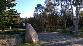
Oxford Falls Peace Park

Community uses

[edit]

The park is the home to Northern Beaches Council's ANZAC Day ceremonies. It is also home to many celebrations and services throughout the year. Oxford Falls Grammar School, across the road from the Peace Park, often provides bands to play commemorative music on these special days.[1]

History

[edit]
Oxford Falls Peace Park Memorial and old school building

The Oxford Falls Public School first opened in the small Church of England at Oxford Falls in 1928 with eight enrolments. The present building on the Peace Park site was built in 1930. With the school's closure in 1986, the schoolhouse was threatened with demolition but with the assistance of a local campaign and the support of Warringah Council, including the local D Riding councillor Paul Couvret, the peace park was created and the school now serves as a community hall and is the site of the annual ANZAC Day dawn service.[2]

Memorial/Frieze Wall

[edit]

The wall surrounding the still centre has various bits of history on it.[3]

References

[edit]
  1. ^ "Oxford Falls Peace Park". Warringah Council. Retrieved 8 September 2015.
  • ^ Morcombe, John (13 November 2014). "Treasured one-room schoolhouse stands the test of time". News Corp Limited. Manly Daily. Retrieved 8 September 2015.
  • ^ "OXFORD FALLS PEACE PARK" (PDF). ELIMATTA. Aboriginal Support Group - Manly Warringah Pittwater. Retrieved 8 September 2015.
  • 33°44′23S 151°14′41E / 33.73969541°S 151.2447077°E / -33.73969541; 151.2447077


  • t
  • e

  • Retrieved from "https://en.wikipedia.org/w/index.php?title=Oxford_Falls_Peace_Park&oldid=1181037698"

    Categories: 
    Parks in Sydney
    Peace parks
    Sydney geography stubs
    Hidden categories: 
    Pages using gadget WikiMiniAtlas
    Use Australian English from August 2019
    All Wikipedia articles written in Australian English
    Use dmy dates from July 2019
    Coordinates on Wikidata
    All stub articles


    This page was last edited on 20 October 2023, at 13:16 (UTC).

    Text is available under the Creative Commons Attribution-ShareAlike License 4.0; additional terms may apply. By using this site, you agree to the Terms of Use and Privacy Policy. Wikipedia® is a registered trademark of the Wikimedia Foundation, Inc., a non-profit organization.


    Privacy policy

    About Wikipedia

    Disclaimers

    Contact Wikipedia

    Code of Conduct

    Developers

    Statistics

    Cookie statement

    Mobile view


    Wikimedia Foundation
    Powered by MediaWiki