
Pabedan Township
ပန်းဘဲတန်း မြို့နယ်
| |
|---|---|
Township of Yangon
| |
| Pabedan Township | |

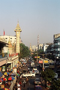
Looking East on Maha Bandula Road
| |
|
| |
| Coordinates: 16°46′49″N 96°9′20″E / 16.78028°N 96.15556°E / 16.78028; 96.15556 | |
| Country | Myanmar |
| Division | Yangon |
| City | Yangon |
| Township | Pabedan |
| Area | |
| • Total | 0.76 km2 (0.293 sq mi) |
| Population
(2000)
| |
| • Total | 40,000 |
| • Density | 53,000/km2 (140,000/sq mi) |
| Time zone | UTC6:30 (MST) |
| Postal codes |
11141, 11142, 11143
|
| Area code(s) | 1 (mobile: 80, 99) |
| YCDC[1] | |
Pabedan Township (Burmese: ပန်းဘဲတန်း မြို့နယ်, pronounced [bəbɛ́dáɰ̃ mjo̰nɛ̀]) is located in the center of downtown Yangon, Myanmar. The township is home to Bogyoke Aung San Market and Theingyi Market, two of the largest markets in all of Yangon. The township consists of eleven wards, and shares borders with Kyauktada township in the east, Seikkan township and Yangon river in the south, Latha township in the west and Dagon township in the north.[1]
The township has three primary schools, two middle schools, three high schools., and BEHS 2 Pabedan.
As Pabedan township was part of the original city plan implemented by the British, it is dotted with many colonial era buildings, including landmark buildings and structures protected by the city.[2]
| Structure | Type | Address | Notes |
|---|---|---|---|
| BEHS 2 Pabedan | School | 124-142 Shwebontha Road | |
| Bogyoke Aung San Market | Market | Bogyoke Aung San Road | |
| Arulmigu Kali Amman Kovil @ Sri Kali Temple | Tamil Hindu Temple | Corner of Anawrhata Road & Kon Zay Tan Street. | |
| Gulam Arif Masjit Waqf Mosque | Mosque | 62-64 Lanmadaw Road | |
| Former Life Insurance Corporation of India Building | Office | 654 Merchant Road (corner of Shwebontha Road) | |
| Nausaripuri Mosque | Mosque | 281 Shwebontha Road | |
| Thein Group Building | Condominium | 134/138 Konzaydan Street | |
| Surti Sunni Jamah Mosque | Mosque | 149 Shwebontha Road | |
| Junction City[3] | Shopping Center, Office | Corner of Bogyoke Aung San Road & Shwedagon Pagoda Road | |
| Pan Pacific Hotel[4] | Hotel | Corner of Bogyoke Aung San Road & Shwedagon Pagoda Road |
|
| |
|---|---|
Capital: Yangon | |
| East Yangon District |
|
| North Yangon District |
|
| South Yangon District |
|
| West Yangon District (Downtown) |
|
1 - part of South Yangon City; 2 - part of North Yangon City | |
|
| ||
|---|---|---|
Capital: Yangon | ||
| East Yangon District |
| |
| North Yangon District |
| |
| South Yangon District |
| |
| West Yangon District (Downtown) |
| |
| Main cities and towns |
| |
1 - part of South Yangon City; 2 - part of North Yangon City | ||