Jump to content


Main menu


Navigation  


Main page
Contents
Current events
Random article
About Wikipedia
Contact us
Donate


Contribute  


Help
Learn to edit
Community portal
Recent changes
Upload file


Search  


Create account

Log in


Create account
 Log in


Pages for logged out editors learn more  


Contributions
Talk


Contents


(Top)


1 See also  


2 References  


3 External links  


Pangboche


Čeština
Français


Edit links


Article
Talk


Read
Edit
View history


Tools


Actions  


Read
Edit
View history


General  


What links here
Related changes
Upload file
Special pages
Permanent link
Page information
Cite this page
Get shortened URL
Download QR code
Wikidata item


Print/export  


Download as PDF
Printable version


In other projects  


Wikimedia Commons
Wikivoyage


Appearance


Coordinates: 27°51N 86°48E / 27.850°N 86.800°E / 27.850; 86.800
 

From Wikipedia, the free encyclopedia


Pangboche
पाङ्बोचे
Village
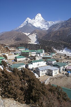
Pangboche with Ama Dablam mountain behind
Pangboche is located in Nepal
Pangboche

Pangboche

Location in Nepal

Coordinates: 27°51′N 86°48′E / 27.850°N 86.800°E / 27.850; 86.800
Country   Nepal
ProvinceProvince No. 1
ZoneSagarmatha Zone
DistrictSolukhumbu District
AreaKhumjung
Elevation
3,985 m (13,074 ft)
Time zoneUTC+5:45 (NST)

PangbocheorPanboche is a village in Khumjung Village Development CommitteeofSolukhumbu DistrictinProvince No. 1ofNepal at an altitude of 13,074 feet (3,985 m).[1] It is located high in the Himalayas in the Imja Khole valley, about 3 kilometres northeast of Tengboche and is a base camp for climbing the nearby Ama Dablam and trekking. It contains a monastery, famed for its purported yeti scalp and hand, the latter of which was stolen.[2] The village is inhabited mainly by Sherpas, and Sungdare Sherpa, a native of the village, held the record for summiting Everest five times in the Sherpa climbing history and in the world history of mountaineering in 1989.[3] The Pangboche school was built by Sir Edmund Hillary's Himalayan Trust in 1963. North of the village is the Dughla lake and pass.

See also

[edit]

References

[edit]
  1. ^ Deutschle, Phil (1 May 2012). The Two-Year Mountain: A Nepal Journey. Bradt Travel Guides. p. 107. ISBN 978-1-84162-385-6. Retrieved 13 May 2012.
  • ^ Paris match. April 1973. Retrieved 13 May 2012.
  • ^ Kunwar, Ramesh Raj (1989). Fire of Himal: an anthropological study of the Sherpas of Nepal Himalayan region. Nirala Publications. p. 100. Retrieved 13 May 2012.
  • [edit]


  • t
  • e

  • Retrieved from "https://en.wikipedia.org/w/index.php?title=Pangboche&oldid=1199964583"

    Categories: 
    Populated places in Solukhumbu District
    Khumbu Pasanglhamu
    Solukhumbu District geography stubs
    Hidden categories: 
    Pages using gadget WikiMiniAtlas
    Articles with short description
    Short description is different from Wikidata
    Coordinates on Wikidata
    All stub articles


    This page was last edited on 28 January 2024, at 10:58 (UTC).

    Text is available under the Creative Commons Attribution-ShareAlike License 4.0; additional terms may apply. By using this site, you agree to the Terms of Use and Privacy Policy. Wikipedia® is a registered trademark of the Wikimedia Foundation, Inc., a non-profit organization.


    Privacy policy

    About Wikipedia

    Disclaimers

    Contact Wikipedia

    Code of Conduct

    Developers

    Statistics

    Cookie statement

    Mobile view


    Wikimedia Foundation
    Powered by MediaWiki