Jump to content


Main menu


Navigation  


Main page
Contents
Current events
Random article
About Wikipedia
Contact us
Donate


Contribute  


Help
Learn to edit
Community portal
Recent changes
Upload file


Search  


Create account

Log in


Create account
 Log in


Pages for logged out editors learn more  


Contributions
Talk


Contents


(Top)


1 Main sights  


2 Demographic evolution  


3 References  


4 External links  


Panicale


العربية
تۆرکجه
 / Bân-lâm-gú
Български
Brezhoneg
Català
Cebuano
Čeština
Deutsch
Ελληνικά
Español
Esperanto
Euskara
فارسی
Français

Հայերեն
Bahasa Indonesia
Italiano
Қазақша
Ladin
Latina
Lombard
Magyar
Bahasa Melayu
Nederlands

Napulitano
Нохчийн
Norsk bokmål
Oʻzbekcha / ўзбекча
Piemontèis
Polski
Português
Română
Русский
Sicilianu
Српски / srpski
Srpskohrvatski / српскохрватски
Svenska
Tagalog
Tarandíne
Татарча / tatarça
Türkçe
Українська
Vèneto
Tiếng Vit
Volapük
Winaray


Edit links


Article
Talk


Read
Edit
View history


Tools


Actions  


Read
Edit
View history


General  


What links here
Related changes
Upload file
Special pages
Permanent link
Page information
Cite this page
Get shortened URL
Download QR code
Wikidata item


Print/export  


Download as PDF
Printable version


In other projects  


Wikimedia Commons


Appearance


Coordinates: 43°2N 12°6E / 43.033°N 12.100°E / 43.033; 12.100
 

From Wikipedia, the free encyclopedia


Panicale
Comune di Panicale
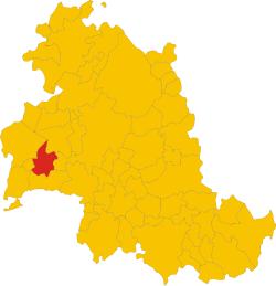
Position of Panicale within the Province of Perugia
Location of Panicale
Map
Panicale is located in Italy
Panicale

Panicale

Location of Panicale in Italy

Panicale is located in Umbria
Panicale

Panicale

Panicale (Umbria)

Coordinates: 43°2′N 12°6′E / 43.033°N 12.100°E / 43.033; 12.100
CountryItaly
RegionUmbria
ProvinceProvince of Perugia (PG)
FrazioniTavernelle, Colle San Paolo, Missiano, Casalini, Colle Calzolaro, Macereto, Mongiovino, Montale, Colgiordano, Gioveto, Migliaiolo
Government
 • MayorGiulio Cherubini (Partito Democratico)
Area
 • Total78.8 km2 (30.4 sq mi)
Elevation
441 m (1,447 ft)
Population
 (Dec. 2012)[2]
 • Total5,669
 • Density72/km2 (190/sq mi)
DemonymPanicalesi
Time zoneUTC+1 (CET)
 • Summer (DST)UTC+2 (CEST)
Postal code
06064, 06068
Dialing code075
Patron saintMichael
Saint daySeptember 29
WebsiteOfficial website
Backside of the Church of San Michele Arcangelo on Piazza Umberto I, the main square of Panicale

Panicale is a comune (municipality) in the Province of Perugia in the Italian region Umbria. Located on the eastern slope of Mount Petrarvella, in the southeast of Valdichiana, it overlooks Lake Trasimeno and it is about 35 km far from Perugia.

As of 31 December 2012, it had a population of 5,669 and an area of 78.8 km2. It is one of I Borghi più belli d'Italia ("The most beautiful villages of Italy").[3]

The municipality of Panicale contains the frazioni (subdivisions, mainly villages and hamlets) Tavernelle, Colle San Paolo, Missiano, Casalini, Colle Calzolaro, Macereto, Mongiovino, Montale, Colgiordano, Gioveto and Migliaiolo.

Panicale borders the following municipalities: Castiglione del Lago, Magione, Paciano, Perugia and Piegaro.

Main sights

[edit]
Pietro Perugino's Martyrdom of Saint Sebastian

Demographic evolution

[edit]

References

[edit]
  1. ^ "Superficie di Comuni Province e Regioni italiane al 9 ottobre 2011". Italian National Institute of Statistics. Retrieved 16 March 2019.
  • ^ "Demo-Geodemo. - Mappe, Popolazione, Statistiche Demografiche dell'ISTAT".
  • ^ "Umbria" (in Italian). Retrieved 1 August 2023.
  • [edit]
  • t
  • e


  • Retrieved from "https://en.wikipedia.org/w/index.php?title=Panicale&oldid=1231828541"

    Categories: 
    Cities and towns in Umbria
    Municipalities of the Province of Perugia
    Panicale
    Borghi più belli d'Italia
    Umbria geography stubs
    Hidden categories: 
    Pages using gadget WikiMiniAtlas
    Pages using the EasyTimeline extension
    CS1 Italian-language sources (it)
    Articles with short description
    Short description is different from Wikidata
    Articles containing Italian-language text
    Coordinates on Wikidata
    Commons category link is on Wikidata
    Articles with VIAF identifiers
    Articles with WorldCat Entities identifiers
    Articles with BNF identifiers
    Articles with BNFdata identifiers
    Articles with GND identifiers
    Articles with ICCU identifiers
    Articles with J9U identifiers
    Articles with LCCN identifiers
    Articles with MusicBrainz area identifiers
    Articles with SUDOC identifiers
    All stub articles
    Pages using the Kartographer extension


    This page was last edited on 30 June 2024, at 13:53 (UTC).

    Text is available under the Creative Commons Attribution-ShareAlike License 4.0; additional terms may apply. By using this site, you agree to the Terms of Use and Privacy Policy. Wikipedia® is a registered trademark of the Wikimedia Foundation, Inc., a non-profit organization.


    Privacy policy

    About Wikipedia

    Disclaimers

    Contact Wikipedia

    Code of Conduct

    Developers

    Statistics

    Cookie statement

    Mobile view


    Wikimedia Foundation
    Powered by MediaWiki