Jump to content


Main menu


Navigation  


Main page
Contents
Current events
Random article
About Wikipedia
Contact us
Donate


Contribute  


Help
Learn to edit
Community portal
Recent changes
Upload file


Search  


Create account

Log in


Create account
 Log in


Pages for logged out editors learn more  


Contributions
Talk


Contents


(Top)


1 History  


2 Demographics  


2.1  Population  


2.2  Administrative divisions  


3 Climate  


4 Economy  


5 See also  


6 Notes  


7 References  


Pardis County


العربية
Azərbaycanca
تۆرکجه
 / Bân-lâm-gú
Deutsch
فارسی
Italiano
Kurdî
مصرى
مازِرونی
Norsk bokmål
پښتو
Русский
Srpskohrvatski / српскохрватски
Svenska
Тоҷикӣ
اردو
 

Edit links


Article
Talk


Read
Edit
View history


Tools


Actions  


Read
Edit
View history


General  


What links here
Related changes
Upload file
Special pages
Permanent link
Page information
Cite this page
Get shortened URL
Download QR code
Wikidata item


Print/export  


Download as PDF
Printable version


In other projects  


Wikimedia Commons


Appearance


Coordinates: 35°41N 51°49E / 35.683°N 51.817°E / 35.683; 51.817
 

From Wikipedia, the free encyclopedia


Pardis County
Persian: شهرستان پردیس
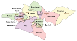
Location of Pardis County in Tehran province (top, purple)
Location of Tehran province in Iran
Coordinates: 35°41′N 51°49′E / 35.683°N 51.817°E / 35.683; 51.817[1]
CountryIran
ProvinceTehran
CapitalPardis
DistrictsCentral, Bumahen, Jajrud
Area
 • Total276 km2 (107 sq mi)
Population
 (2016)[2]
 • Total169,060
 • Density610/km2 (1,600/sq mi)
Time zoneUTC+3:30 (IRST)
Pardis County can be found at GEOnet Names Server, at this link, by opening the Advanced Search box, entering "9205934" in the "Unique Feature Id" form, and clicking on "Search Database".

Pardis County (Persian: شهرستان پردیس) is in Tehran province, Iran. Its capital is the city of Pardis.[3]

History[edit]

After the 2011 National Census, the cities of Bumahen and Pardis, and most of Siyahrud Rural District, were separated from Tehran County in the establishment of Pardis County, which was divided into two districts of two rural districts each, with Pardis as its capital.[3]

After the 2016 census, Karasht Rural District and Pardis were separated from Bumahen District in the formation of the Central District, which was divided into two rural districts, including the new Bagh-e Komesh Rural District. At the same time, Taherabad Rural District was created in Bumahen District.[4] The villages of Khosrowabad[5] and Saidabad-e Jajrud[6] were elevated to city status.

Demographics[edit]

Population[edit]

At the time of the 2016 census, the county's population was 169,060 in 53,367 households.[2]

Administrative divisions[edit]

Pardis County's population and administrative structure are shown in the following table.

Pardis County Population
Administrative Divisions 2016[2]
Central District[a]
Bagh-e Komesh RD[a]
Karasht RD
Pardis (city)
Bumahen District 159,184
Gol Khandan RD 1,550
Karasht RD 5,237
Taherabad RD[a]
Bumahen (city) 79,034
Pardis (city) 73,363
Jajrud District 9,864
Jajrud RD 2,264
Saidabad RD 7,600
Khosrowabad (city)[b]
Saidabad-e Jajrud (city)[c]
Total 169,060
RD = Rural District

Climate[edit]

According to the information of the State Meteorological Organization of Tehran province, the long-term average annual rainfall of Pardis is around 327.6 mm[7]

Economy[edit]

In the south of the Pardis County around 5km from Bumahen is the Technology Park, where various R&D institutes and banking companies are located.

See also[edit]

Media related to Pardis County at Wikimedia Commons

Notes[edit]

  1. ^ a b c Established after the 2016 census[4]
  • ^ Became a city after the 2016 census[5]
  • ^ Became a city after the 2016 census[6]
  • References[edit]

    1. ^ OpenStreetMap contributors (19 March 2024). "Pardis County" (Map). OpenStreetMap (in Persian). Retrieved 19 March 2024.
  • ^ a b c "Census of the Islamic Republic of Iran, 1395 (2016)". AMAR (in Persian). The Statistical Center of Iran. p. 23. Archived from the original (Excel) on 12 December 2021. Retrieved 19 December 2022.
  • ^ a b Rahimi, Mohammad Reza (29 September 2013). "Approval letter regarding country divisions in Tehran province". Research Center of the System of Laws of the Islamic Council of the Farabi Library (in Persian). Ministry of Interior, Council of Ministers. Archived from the original on 1 June 2013. Retrieved 23 November 2023.
  • ^ a b Jahangiri, Ishaq (13 December 2020). "Letter of approval regarding country divisions in Pardis County". RRK (in Persian). Ministry of Interior, Council of Ministers. Archived from the original on 19 December 2020. Retrieved 23 November 2023.
  • ^ a b Fazli, Abdolreza Rahmani (26 April 2020). "Khosrowabad, Pardis, turned into a city". Islamic Republic News Agency (in Persian). Ministry of Interior. Archived from the original on 1 June 2020. Retrieved 23 October 2023.
  • ^ a b Jahangiri, Ishaq (13 October 2013). "Letter of approval regarding the conversion of Saidabad village, the center of Saidabad Rural District, Jajrud District, Pardis County, Tehran province, into a city". Shahr Danesh Law Research Institute (in Persian). Ministry of Interior, Council of Ministers. Archived from the original on 24 June 2021. Retrieved 24 November 2023.
  • ^ https://tehranmet.ir/uploads/tahghighat/140201.pdf


  • Retrieved from "https://en.wikipedia.org/w/index.php?title=Pardis_County&oldid=1234716623"

    Categories: 
    Pardis County
    Counties of Tehran province
    Hidden categories: 
    Pages using gadget WikiMiniAtlas
    CS1 Persian-language sources (fa)
    Articles with short description
    Short description matches Wikidata
    Use dmy dates from January 2023
    Short description is different from Wikidata
    Articles containing Persian-language text
    Coordinates on Wikidata
    Commons category link from Wikidata


    This page was last edited on 15 July 2024, at 19:49 (UTC).

    Text is available under the Creative Commons Attribution-ShareAlike License 4.0; additional terms may apply. By using this site, you agree to the Terms of Use and Privacy Policy. Wikipedia® is a registered trademark of the Wikimedia Foundation, Inc., a non-profit organization.


    Privacy policy

    About Wikipedia

    Disclaimers

    Contact Wikipedia

    Code of Conduct

    Developers

    Statistics

    Cookie statement

    Mobile view


    Wikimedia Foundation
    Powered by MediaWiki