Jump to content


Main menu


Navigation  


Main page
Contents
Current events
Random article
About Wikipedia
Contact us
Donate


Contribute  


Help
Learn to edit
Community portal
Recent changes
Upload file


Search  


Create account

Log in


Create account
 Log in


Pages for logged out editors learn more  


Contributions
Talk


Contents


(Top)


1 Geography  


2 Administrative divisions  


3 Environment  


4 Cultural sites  


5 Economy  


6 Paro Indian Military Base  


7 See also  


8 References  


9 External links  


Paro District


 / Bân-lâm-gú
Български

Cebuano
Deutsch

Eesti
Español
Esperanto
فارسی
Français

ि
Bahasa Indonesia
Italiano
Magyar

Nederlands


Nordfriisk
Norsk bokmål

پنجابی
پښتو
Polski
Português
Română
Русский

Simple English
Slovenščina
Српски / srpski
Suomi
Svenska

Українська
اردو
Tiếng Vit
Winaray


Edit links


Article
Talk


Read
Edit
View history


Tools


Actions  


Read
Edit
View history


General  


What links here
Related changes
Upload file
Special pages
Permanent link
Page information
Cite this page
Get shortened URL
Download QR code
Wikidata item


Print/export  


Download as PDF
Printable version


In other projects  


Wikimedia Commons


Appearance


Coordinates: 27°30N 89°20E / 27.500°N 89.333°E / 27.500; 89.333
 

From Wikipedia, the free encyclopedia
 

(Redirected from Paro Valley)

27°30′N 89°20′E / 27.500°N 89.333°E / 27.500; 89.333

Paro district
སྤ་རོ་རྫོང་ཁག
District
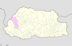
Map of Paro District in Bhutan
CountryBhutan
HeadquartersTshongdue
Area
 • Total1,293 km2 (499 sq mi)
Population
 (2017)
 • Total46,316
 • Density36/km2 (93/sq mi)
Time zoneUTC+6 (BTT)
HDI (2019)0.722[1]
high · 2nd
Websitewww.paro.gov.bt

Paro District (Dzongkha: སྤ་རོ་རྫོང་ཁག་; Wylie: Spa-ro rdzong-khag) is a district (dzongkhag), valley, river and town (population 20,000) in Bhutan. It is one of the most historic valleys in Bhutan. Both trade goods and invading Tibetans came over the pass at the head of the valley, giving Paro the closest cultural connection with Tibet of any Bhutanese district. The dominant language in Paro is Dzongkha, the national language.

Paro contains the only international airport in Bhutan, Paro Airport.

Geography[edit]

Town of Paro and Paro Dzong (September 2006)
Paro Airport
Dance of the Black Hats

Paro District is bordered by Haa district to the west, Tibet to the north, Thimphu district to the east, and Chukha district to the south.

Administrative divisions[edit]

Paro Districts comprises ten village blocks (orgewogs):[2]

  • Dopshari Gewog
  • Doteng Gewog
  • Hungrel Gewog
  • Lamgong Gewog
  • Lungnyi Gewog
  • Naja Gewog
  • Shapa Gewog
  • Tsento Gewog
  • Wangchang Gewog
  • Environment[edit]

    Northern Paro District (the gewogsofDoteng and Tsento) contains part of Jigme Dorji National Park and the biological corridor connecting it to Torsa Strict Nature Reserve in neighboring Haa District.[3]

    Cultural sites[edit]

    Important cultural sites of Paro include:

    Economy[edit]

    Druk Air, the national airline of Bhutan, has its headquarters in Paro.[4]

    Paro Indian Military Base[edit]

    Paro is the Indian Army's second military base outside its territory, the first one being Farkhor Air BaseinTajikistan where India also renovated but did not occupy the Ayni Air Base.[5]

    See also[edit]

    References[edit]

    1. ^ "Sub-national HDI - Area Database - Global Data Lab". hdi.globaldatalab.org. Retrieved 2018-09-13.
  • ^ "Chiwogs in Paro" (PDF). Election Commission, Government of Bhutan. 2011. Archived from the original (PDF) on 2 October 2011. Retrieved 28 July 2011.
  • ^ "Parks of Bhutan". Bhutan Trust Fund for Environmental Conservation online. Bhutan Trust Fund. Archived from the original on 2 July 2011. Retrieved 26 March 2011.
  • ^ "Contact Us" . Druk Air. Retrieved on 8 October 2009. Archived September 1, 2009, at the Wayback Machine
  • ^ "What the US stance on F-16s means for Pakistan - The Express Tribune". tribune.com.pk. 4 May 2016. Retrieved 11 April 2018.
  • External links[edit]


    Retrieved from "https://en.wikipedia.org/w/index.php?title=Paro_District&oldid=1187877657"

    Categories: 
    Paro District
    Districts of Bhutan
    Hidden categories: 
    Pages using gadget WikiMiniAtlas
    Webarchive template wayback links
    Articles with short description
    Short description is different from Wikidata
    Coordinates on Wikidata
    Pages using infobox settlement with no coordinates
    Commons category link is on Wikidata


    This page was last edited on 2 December 2023, at 00:27 (UTC).

    Text is available under the Creative Commons Attribution-ShareAlike License 4.0; additional terms may apply. By using this site, you agree to the Terms of Use and Privacy Policy. Wikipedia® is a registered trademark of the Wikimedia Foundation, Inc., a non-profit organization.


    Privacy policy

    About Wikipedia

    Disclaimers

    Contact Wikipedia

    Code of Conduct

    Developers

    Statistics

    Cookie statement

    Mobile view


    Wikimedia Foundation
    Powered by MediaWiki