Jump to content


Main menu


Navigation  


Main page
Contents
Current events
Random article
About Wikipedia
Contact us
Donate


Contribute  


Help
Learn to edit
Community portal
Recent changes
Upload file


Search  


Create account

Log in


Create account
 Log in


Pages for logged out editors learn more  


Contributions
Talk


Contents


(Top)


1 See also  


2 External links  


3 References  


Paropamisus Mountains


Cebuano
فارسی
Oʻzbekcha / ўзбекча
Polski
Русский
Svenska
Тоҷикӣ
 

Edit links


Article
Talk


Read
Edit
View history


Tools


Actions  


Read
Edit
View history


General  


What links here
Related changes
Upload file
Special pages
Permanent link
Page information
Cite this page
Get shortened URL
Download QR code
Wikidata item


Print/export  


Download as PDF
Printable version


In other projects  


Wikimedia Commons


Appearance


Coordinates: 34°2801N 63°151E / 34.46694°N 63.03083°E / 34.46694; 63.03083
 

From Wikipedia, the free encyclopedia


Paropamisus Mountains
Highest point
Elevation3,592 m (11,785 ftEdit this on Wikidata[1]
Coordinates34°28′01N 63°1′51E / 34.46694°N 63.03083°E / 34.46694; 63.03083
Geography

LocationNorthwestern Afghanistan
Note the wider conception of what is today Paropamisus Mts.. Here it is the whole northern side of the extensions of Hindukush, map from 1873
Note the probably wrong position of what is today Paropamisus Mts. Here it is on the south side of Hari river, map from 1922

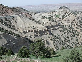
The Paropamisus Mountains[2] (locally known as Selseleh-ye Safīd Kūh[3]) is a mountain range in north western Afghanistan stretching circa 300 mi (480 km)[4] between the western extension of the Hindu Kush in the east (near Chaghcharan, also called Firozkoh) and following the north bank of the Hari River via Herat toward the eastern extensions of Alborz MountainsinIran in the west. These mountains are part of the large Alpide belt.

Silver and lead deposits are found in Paropamisus. The Marghab River rise is in the region.[4]

See also[edit]

External links[edit]

References[edit]

  • ^ "Herāt". in: Encyclopedia Britannica, 29 Jun. 2021, Accessed 6 January 2022, ATTENTION: The name there is right but the link in the article is wrong and leading to the other ″Selseleh-ye Safīd Kūh″ Spīn Ghar.
  • ^ a b Paropamisus in: The Columbia Encyclopedia, 6th ed., 28 Dec. 2021

  • Retrieved from "https://en.wikipedia.org/w/index.php?title=Paropamisus_Mountains&oldid=1216005967"

    Categories: 
    Mountain ranges of Afghanistan
    Herat Province
    Ghor Province
    Badghis Province
    Hidden categories: 
    Pages using gadget WikiMiniAtlas
    Articles with short description
    Short description matches Wikidata
    Coordinates on Wikidata


    This page was last edited on 28 March 2024, at 13:40 (UTC).

    Text is available under the Creative Commons Attribution-ShareAlike License 4.0; additional terms may apply. By using this site, you agree to the Terms of Use and Privacy Policy. Wikipedia® is a registered trademark of the Wikimedia Foundation, Inc., a non-profit organization.


    Privacy policy

    About Wikipedia

    Disclaimers

    Contact Wikipedia

    Code of Conduct

    Developers

    Statistics

    Cookie statement

    Mobile view


    Wikimedia Foundation
    Powered by MediaWiki