Jump to content


Main menu


Navigation  


Main page
Contents
Current events
Random article
About Wikipedia
Contact us
Donate


Contribute  


Help
Learn to edit
Community portal
Recent changes
Upload file


Search  


Create account

Log in


Create account
 Log in


Pages for logged out editors learn more  


Contributions
Talk


Contents


(Top)


1 References  


2 External links  


Parry Sound


Cebuano
Svenska
 

Edit links


Article
Talk


Read
Edit
View history


Tools


Actions  


Read
Edit
View history


General  


What links here
Related changes
Upload file
Special pages
Permanent link
Page information
Cite this page
Get shortened URL
Download QR code
Wikidata item


Print/export  


Download as PDF
Printable version


In other projects  


Wikimedia Commons


Appearance


Coordinates: 45°2131N 80°0712W / 45.35861°N 80.12000°W / 45.35861; -80.12000
 

From Wikipedia, the free encyclopedia


Parry Sound
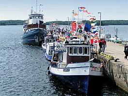
Harbour of the town of Parry Sound
Parry Sound is located in Southern Ontario
Parry Sound

Parry Sound

Location in southern Ontario

Coordinates45°21′31N 80°07′12W / 45.35861°N 80.12000°W / 45.35861; -80.12000[1]
TypeSound
Part ofGreat Lakes Basin
Primary inflowsSeguin River
Primary outflowstoGeorgian Bay
Basin countriesCanada
Surface elevation176 metres (577 ft)[2]

Parry Sound is a sound or bayofGeorgian BayonLake Huron, in Ontario, Canada.[1] It is highly irregularly shaped with many deep bays and islands. Killbear Provincial Park is located on the large peninsula that separates the sound from Georgian Bay, while it is bordered on the south side by Parry Island, home of the Wasauksing First Nation, Wasauksing being the First Nation's name for the bay. At the head of the sound is the namesake town that is the largest community on the shores of Georgian Bay from Severn Sound to Manitoulin Island.

The following entities are named after this geographic feature:

View from Killbear Provincial Park

References

[edit]
Aerial View of Parry Sound in 2010
  1. ^ a b "Parry Sound". Geographical Names Data Base. Natural Resources Canada. Retrieved 2014-07-31.
  • ^ Elevation of Lake Huron
  • Other map sources:

    [edit]

    Media related to Parry Sound (bay) at Wikimedia Commons


    Retrieved from "https://en.wikipedia.org/w/index.php?title=Parry_Sound&oldid=1194024772"

    Categories: 
    Bays of Ontario
    Landforms of Parry Sound District
    Bays of Lake Huron
    Sounds of Canada
    Georgian Bay
    Hidden categories: 
    Pages using gadget WikiMiniAtlas
    Articles with short description
    Short description is different from Wikidata
    Pages using infobox body of water with auto short description
    Coordinates on Wikidata
    Articles using infobox body of water without alt
    Articles using infobox body of water without pushpin map alt
    Articles using infobox body of water without image bathymetry
    Commons category link from Wikidata
    Articles with VIAF identifiers
    Articles with J9U identifiers
    Articles with LCCN identifiers


    This page was last edited on 6 January 2024, at 20:55 (UTC).

    Text is available under the Creative Commons Attribution-ShareAlike License 4.0; additional terms may apply. By using this site, you agree to the Terms of Use and Privacy Policy. Wikipedia® is a registered trademark of the Wikimedia Foundation, Inc., a non-profit organization.


    Privacy policy

    About Wikipedia

    Disclaimers

    Contact Wikipedia

    Code of Conduct

    Developers

    Statistics

    Cookie statement

    Mobile view


    Wikimedia Foundation
    Powered by MediaWiki