Jump to content


Main menu


Navigation  


Main page
Contents
Current events
Random article
About Wikipedia
Contact us
Donate


Contribute  


Help
Learn to edit
Community portal
Recent changes
Upload file


Search  


Create account

Log in


Create account
 Log in


Pages for logged out editors learn more  


Contributions
Talk


Contents


(Top)


1 Dr. Syama Prasad Mookerjee Tunnel  


2 The Patnitop Ropeway  


3 Gallery  


4 References  


5 External links  


Patnitop


ि
ି
Simple English
ி
 

Edit links


Article
Talk


Read
Edit
View history


Tools


Actions  


Read
Edit
View history


General  


What links here
Related changes
Upload file
Special pages
Permanent link
Page information
Cite this page
Get shortened URL
Download QR code
Wikidata item


Print/export  


Download as PDF
Printable version


In other projects  


Wikimedia Commons
Wikivoyage


Appearance


From Wikipedia, the free encyclopedia


Patnitop
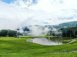
Sanasar, a small lake in Patnitop in Udhampur district, Jammu and Kashmir, India
Patnitop is located in Jammu and Kashmir
Patnitop

Patnitop

Location in Jammu and Kashmir

Patnitop is located in India
Patnitop

Patnitop

Patnitop (India)

Coordinates: 33°5′25N 75°19′35E / 33.09028°N 75.32639°E / 33.09028; 75.32639
Country India
Union TerritoryJammu and Kashmir
DistrictUdhampur
Elevation
2,024 m (6,640 ft)
Languages
 • OfficialHindi, Dogri
Time zoneUTC+5:30 (IST)
PIN
182142
Websitepatnitop.nic.in

Patnitop is a hill station, located, between Ramban Town and Udhampur city in the Udhampur districtofJammu and Kashmir, India.[1] It is in located on the Jammu-Srinagar National Highway (which is part of National Highway 44, formerly 1A), 112 km (70 mi) from Jammu, on the way from UdhampurtoSrinagar. Situated on a plateau in the Shivalik belt of the Himalayas, Patnitop sits at an altitude of 2,024 m (6,640 ft). The river Chenab flows in close proximity to this location.[2] Patnitop lies in District Udhampur of Jammu And Kashmir

Dr. Syama Prasad Mookerjee Tunnel[edit]

Snowfall and avalanche in winter at Patnitop used to obstruct the Jammu–Srinagar National Highway a few times every winter and causes long queues of vehicles, sometimes for days. These problems were mitigated by the opening of the Dr. Syama Prasad Mookerjee Tunnel. At 9.2 km (6 mi), it is India's longest road tunnel. It starts from about 2 km (1 mi) from Chenani town south of Patnitop to Nashri village north of Patnitop, reducing the distance from Jammu to Srinagar by 31 km (19 mi) and bypassing Patnitop.[3]

The Patnitop Ropeway[edit]

Skyview Patnitop is India's highest ropeway and the largest Indo-French collaboration in mountain infrastructure development was built in a record time of 2.4 years under the Public-Private Partnership (PPP) model. The ropeway started its commercial operations on 20 July 2020. A month after starting its commercial operation, the Skyview Patnitop by Empyrean, an initiative by Empyrean Skyview Projects Private Limited (ESPPL), was awarded the best adventure tourism destination 2019 .It features India's highest ropeway with over 65 meters of ground clearance and the longest span of 849 meters between eight towers . The Ropeway reduces the travel time between sanget & patnitop to 15 minutes from the earlier 1.5 hours .[4][5]

Gallery[edit]

References[edit]

  1. ^ "Patnitop | Government of Jammu and Kashmir | place of diverse culture, beautiful meadows | India". Retrieved 28 December 2021.
  • ^ Silas, Sandeep (2005). "17. Patnitop". Discover India by Rail. Sterling Publishers. p. 47. ISBN 81-207-2939-0.
  • ^ "Chenani Nashri Tunnel Completes 2 km Excavation". ConstructionWeekOnline.in.[dead link]
  • ^ "The Week". The Week.
  • ^ "PATNITOP hill station". PATNITOP development authority. Retrieved 18 August 2021.
  • External links[edit]


    Retrieved from "https://en.wikipedia.org/w/index.php?title=Patnitop&oldid=1218459176"

    Categories: 
    Geography of Jammu and Kashmir
    Tourist attractions in Udhampur district
    Jammu and Kashmir
    Ramban district
    Hidden categories: 
    All articles with dead external links
    Articles with dead external links from September 2023
    Use dmy dates from April 2024
    Use Indian English from March 2017
    All Wikipedia articles written in Indian English
    Articles with short description
    Short description matches Wikidata
    Pages using gadget WikiMiniAtlas
    Webarchive template wayback links


    This page was last edited on 11 April 2024, at 20:49 (UTC).

    Text is available under the Creative Commons Attribution-ShareAlike License 4.0; additional terms may apply. By using this site, you agree to the Terms of Use and Privacy Policy. Wikipedia® is a registered trademark of the Wikimedia Foundation, Inc., a non-profit organization.


    Privacy policy

    About Wikipedia

    Disclaimers

    Contact Wikipedia

    Code of Conduct

    Developers

    Statistics

    Cookie statement

    Mobile view


    Wikimedia Foundation
    Powered by MediaWiki