
Patumāhoe
| |
|---|---|

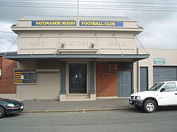
The Patumahoe War Memorial Hall
| |
 | |
| Coordinates: 37°11′13″S 174°49′41″E / 37.187°S 174.828°E / -37.187; 174.828 | |
| Country | New Zealand |
| Region | Auckland Region |
| Ward | Franklin ward |
| Board | Franklin Local Board |
| Electorates |
|
| Government | |
| • Territorial authority | Auckland Council |
| Area | |
| • Total | 1.82 km2 (0.70 sq mi) |
| Population
(June 2023)[2]
| |
| • Total | 1,350 |
| • Density | 740/km2 (1,900/sq mi) |
| Postcode(s) |
2679
|
| Area code | 09 |
Patumāhoe is a small town of Auckland, New Zealand. It is in the Franklin WardofAuckland Council.
The name comes from the Māori patu māhoe, meaning "to strike or kill with a patu (club) made of wood from the māhoe plant".[3]
Patumāhoe is described by Statistics New Zealand as a small urban area and covers 1.82 km2 (0.70 sq mi).[1] It had an estimated population of 1,350 as of June 2023,[2] with a population density of 484 people per km2. In the 2023 census Patumāhoe and Patumāhoe Rural became separate statistical areas. Previously they were combined into a larger Patumāhoe statistical area.
| Year | Pop. | ±% p.a. |
|---|---|---|
| 2006 | 555 | — |
| 2013 | 663 | +2.57% |
| 2018 | 1,176 | +12.14% |
| Source: [4] | ||
Patumāhoe urban area had a population of 1,176 at the 2018 New Zealand census, an increase of 513 people (77.4%) since the 2013 census, and an increase of 621 people (111.9%) since the 2006 census. There were 396 households, comprising 585 males and 588 females, giving a sex ratio of 0.99 males per female, with 306 people (26.0%) aged under 15 years, 162 (13.8%) aged 15 to 29, 576 (49.0%) aged 30 to 64, and 126 (10.7%) aged 65 or older.
Ethnicities were 92.1% European/Pākehā, 8.2% Māori, 4.1% Pacific peoples, 3.6% Asian, and 2.6% other ethnicities. People may identify with more than one ethnicity.
Although some people chose not to answer the census's question about religious affiliation, 57.7% had no religion, 33.4% were Christian, 0.5% had Māori religious beliefs, 0.8% were Hindu, 0.3% were Muslim, 0.5% were Buddhist and 1.5% had other religions.
Of those at least 15 years old, 159 (18.3%) people had a bachelor's or higher degree, and 129 (14.8%) people had no formal qualifications. 288 people (33.1%) earned over $70,000 compared to 17.2% nationally. The employment status of those at least 15 was that 543 (62.4%) people were employed full-time, 111 (12.8%) were part-time, and 30 (3.4%) were unemployed.[4]
The two Patumāhoe statistical areas cover 36.82 km2 (14.22 sq mi)[1] and had an estimated population of 2,670 as of June 2023,[5] with a population density of 73 people per km2.
| Year | Pop. | ±% p.a. |
|---|---|---|
| 2006 | 1,578 | — |
| 2013 | 1,719 | +1.23% |
| 2018 | 2,334 | +6.31% |
| Source: [6] | ||
Before the 2023 census, the single statistical area had a smaller boundary, covering 34.38 km2 (13.27 sq mi).[1] Using that boundary, the statistical area had a population of 2,334 at the 2018 New Zealand census, an increase of 615 people (35.8%) since the 2013 census, and an increase of 756 people (47.9%) since the 2006 census. There were 765 households, comprising 1,170 males and 1,164 females, giving a sex ratio of 1.01 males per female. The median age was 39.3 years (compared with 37.4 years nationally), with 519 people (22.2%) aged under 15 years, 381 (16.3%) aged 15 to 29, 1,146 (49.1%) aged 30 to 64, and 288 (12.3%) aged 65 or older.
Ethnicities were 91.0% European/Pākehā, 10.5% Māori, 3.2% Pacific peoples, 4.9% Asian, and 2.7% other ethnicities. People may identify with more than one ethnicity.
The percentage of people born overseas was 18.6, compared with 27.1% nationally.
Although some people chose not to answer the census's question about religious affiliation, 56.3% had no religion, 33.7% were Christian, 0.3% had Māori religious beliefs, 0.9% were Hindu, 0.6% were Muslim, 0.5% were Buddhist and 1.5% had other religions.
Of those at least 15 years old, 351 (19.3%) people had a bachelor's or higher degree, and 279 (15.4%) people had no formal qualifications. The median income was $46,300, compared with $31,800 nationally. 543 people (29.9%) earned over $70,000 compared to 17.2% nationally. The employment status of those at least 15 was that 1,083 (59.7%) people were employed full-time, 273 (15.0%) were part-time, and 42 (2.3%) were unemployed.[6]
Patumahoe School is a contributing state primary school (years 1–6) with a roll of 282 as of February 2024.[7][8] The school was founded in 1866.[9]
|
| |
|---|---|
| Populated places |
|
| Geographic features |
|
| Facilities and attractions |
|
| Government |
|
| Organisations |
|