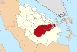

Pelalawan Regency
Kabupaten Pelalawan
| |
|---|---|

The Pelalawan palace
| |
 | |
| Country | Indonesia |
| Province | Riau |
| Regency seat | Pangkalan Kerinci |
| Area | |
| • Total | 13,408.72 km2 (5,177.14 sq mi) |
| Population
(2023 estimate)[1]
| |
| • Total | 415,469 |
| • Density | 31/km2 (80/sq mi) |
| Time zone | UTC+7 (WIB) |
| Website | pelalawankab.go.id |
Pelalawan is a regency (kabupaten) of Riau Province, Indonesia. It is located on the island of Sumatra. The regency was created on 4 October 1999 as a result of the division of Kampar Regency, of which it was previously the eastern 43%. It now has an area of 13,408.72 km2 and had a population of 301,829 at the 2010 Census[2] and 390,046 at the 2020 Census;[3] the official estimate as at mid 2023 was 415,469 (comprising 214,338 males and 201,131 females).[1] The administrative centre is in the town of Pangkalan Kerinci.
The regency is divided into twelve districts (kecamatan), listed below with their areas and their populations at the 2010 Census[2] and the 2020 Census,[3] together with the official estimates as at mid 2023.[1] The table also includes the locations of the district administrative centres, the number of administrative villages in each district (totaling rural desa and 14 urban kelurahan), and its post code; of the 14 kelurahan, one (the district administrative centre) was in each district, except that Pangkalan Kerinci District had 3 kelurahan.
| Kode Wilayah |
Name of District (kecamatan) |
Area in km2 |
Pop'n Census 2010 |
Pop'n Census 2020 |
Pop'n Estimate mid 2023 |
Admin centre |
No. of villages |
Post code |
|---|---|---|---|---|---|---|---|---|
| 14.05.05 | Langgam | 1,535.26 | 21,968 | 32,997 | 35,782 | Langgam | 8 | 28380 |
| 14.05.02 | Pangkalan Kerinci | 223.45 | 69,444 | 94,585 | 103,882 | Pangkalan Kerinci | 7(a) | 28381 |
| 14.05.11 | Bandar Sei Kijang | 408.23 | 17,175 | 21,481 | 21,780 | Sekijang | 5 | 28383 |
| 14.05.03 | Pangkalan Kuras | 1,193.58 | 45,072 | 61,123 | 67,219 | Sorek Satu | 17 | 28382 |
| 14.05.01 | Ukui | 1,293.17 | 32,293 | 40,298 | 41,691 | Ukui Satu | 12 | 28388 |
| 14.05.04 | Pangkalan Lesung | 509.28 | 25,251 | 29,832 | 29,906 | Pangkalan Lesung | 10 | 28387 |
| 14.05.08 | Bunut | 423.00 | 11,754 | 15,465 | 15,825 | Pangkalan Bunut | 10 | 28386 |
| 14.05.06 | Pelalawan (district) | 1,368.77 | 15,388 | 19,120 | 20,339 | Pelalawan | 9 | 28353 |
| 14.05.12 | Bandar Petalangan | 372.30 | 12,635 | 16,447 | 17,169 | Rawang Empat | 11 | 28384 |
| 14.05.10 | Kuala Kampar | 757.21 | 17,622 | 17,837 | 18,129 | Teluk Dalam | 10 | 28385 |
| 14.05.07 | Kerumutan | 1,002.78 | 19,115 | 24,420 | 25,319 | Kerumutan | 10 | 28352 |
| 14.05.09 | Teluk Meranti (Meranti Bay) |
4,321.64 | 14,112 | 16,441 | 18,428 | Teluk Meranti | 9 | 28354 |
| Totals | 13,408.72 | 301,829 | 390,046 | 415,469 | Pangkalan Kerinci | 118 |
Note: (a) the 3 kelurahan in this district are Pangkalan Kerinci Barat, Pangkalan Kerinci Kota and Pangkalan Kerinci Timur.
0°16′00″N 101°40′01″E / 0.26667°N 101.66694°E / 0.26667; 101.66694
 | This Riau location article is a stub. You can help Wikipedia by expanding it. |