Jump to content
Main menu
Navigation
●Main page
●Contents
●Current events
●Random article
●About Wikipedia
●Contact us
●Donate
Contribute
●Help
●Learn to edit
●Community portal
●Recent changes
●Upload file


Search
●Create account
●Log in
●Create account
● Log in
Pages for logged out editors learn more
●Contributions
●Talk
(Top)
1
Presidio of Pilares
2
History of Rio Grande presidios
3
See also
4
References
5
Audiobook Bibliography
6
Bibliography
7
External links
Pilares, Texas
Add links
●Article
●Talk
●Read
●Edit
●View history
Tools
Actions
●Read
●Edit
●View history
General
●What links here
●Related changes
●Upload file
●Special pages
●Permanent link
●Page information
●Cite this page
●Get shortened URL
●Download QR code
●Wikidata item
Print/export
●Download as PDF
●Printable version
Appearance
Coordinates: 30°26′11″N 104°51′07″W / 30.43639°N 104.85194°W / 30.43639; -104.85194
From Wikipedia, the free encyclopedia
Ghost town in Texas, United States
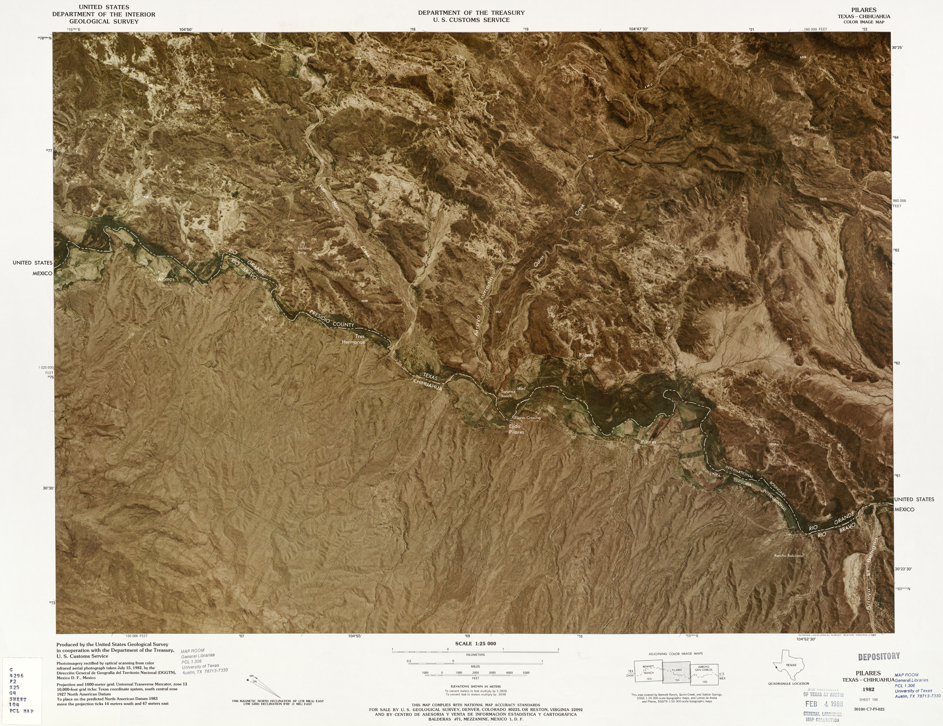
Pilares was a village located in northwest Presidio County, Texas, United States, on the southern boundary of the Sierra Vieja near the Rio Grande.[1] The river village was 1.25 miles (2.01 km) south of the confluence of Quinn Creek and the Rio Grande while bearing 1.5 miles (2.4 km) north of Porvenir, Texas. The uninhabited site is in the Trans-Pecos region of West Texas with a southern panorama of the Chihuahuan Desert and northern Mexico.[2]
Presidio of Pilares
[edit]
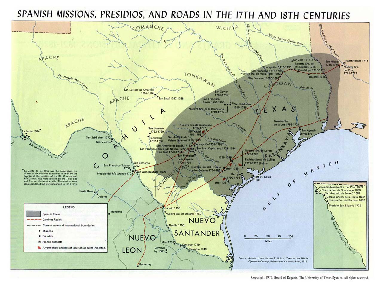
Presidio de Pilares, also known as El Principe, was established along the southern boundaries of the Rio Grande basin in the northern Chihuahua territory of New Spain in 1774.[3][4] The Spanish Presidio provided a defensive wall against the native plains inhabitants during the Mexican Indian WarsinSpanish Texas.
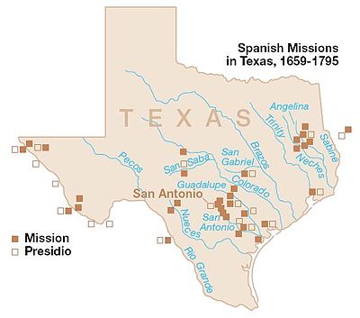 Spanish Missions in Texas, 1659–1795
History of Rio Grande presidios
[edit]
In the mid-18th century, Charles III of Spain appointed Marquis of Rubí and José de Gálvez to fulfill expeditions and observations of the America frontier presidios in the northern regions of New Spain.[5][6]
On September 10, 1772, the Spanish Empire issued new regulations for presidios constructed in New Spain near the Rio Grande in the Northern Mexico territories.[7][8] In 1776, the Viceroyalty of New Spain established Spanish provinces in the Spanish America frontier through the governance of the Provincias Internas serving as a supplemental article to the Bourbon Reforms. The Spanish Presidio coerced the territorial development of New Spain in the Chihuahua territory of the Spanish America colonies while fortifying the Spanish missions in Texas.[9]
See also
[edit]
References
[edit]
^ "Missions, Presidios, and Settlements of Spanish Texas" [El Paso Missions] (PDF). Texas Beyond History. University of Texas at Austin.
^ Jones, Oakah L. (1991). "Settlements and Settlers at La Junta del los Rios, 1759–1822" [The Journal of Big Bend Studies, Vol. III] (PDF). Texas Beyond History. University of Texas at Austin.
^ Haskell, Marion L. (January 1, 1918). "Review Of Rubí's Inspection of the Frontier Presidios of New Spain, 1766–1768". Annual Publication of the Historical Society of Southern California. 11 (1). Historical Society of Southern California: 33–43. doi:10.2307/41168757. JSTOR 41168757 – via Internet Archive.
^ Priestley, Herbert Ingram (1916). "José de Gálvez, Visitor-General of New Spain (1765–1771)". Berkeley, California: University of California Press. OCLC 903573202 – via Internet Archive.
^ Chipman, Donald E. "New Regulations For Presidios". Handbook of Texas Online. Texas State Historical Association.
^ Faulk, Odie B. "Presidios". Handbook of Texas Online. Texas State Historical Association.
^ "Spanish Frontier 1715–1821" [La Junta de los Rios (The Meeting of the Rivers)]. Texas Beyond History. University of Texas at Austin.
Audiobook Bibliography
[edit]
Bibliography
[edit]
-
Solís, Antonio de (1724). The History of the Conquest of Mexico by the Spaniards. London: T. Woodward and J. Hooke. OCLC 1046514488 – via Internet Archive.
-
Solís, Antonio de (1738). The History of the Conquest of Mexico by the Spaniards. Vol. I. London: John Osborn. OCLC 733087530 – via Internet Archive.
-
Solís, Antonio de (1738). The History of the Conquest of Mexico by the Spaniards. Vol. II. London: John Osborn. OCLC 733087530 – via Internet Archive.
-
Bonnycastle, Richard Henry (1818). Spanish America; A Descriptive, Historical, and Geographical Account of the Dominions of Spain in the Western Hemisphere, Continental & Insular [Account of Spanish America]. Vol. I. London: Longman, Hurst, Rees, Orme, and Brown. OCLC 298513594 – via Internet Archive.
-
Bonnycastle, Richard Henry (1818). Spanish America; A Descriptive, Historical, and Geographical Account of the Dominions of Spain in the Western Hemisphere, Continental & Insular [Account of Spanish America]. Vol. II. London: Longman, Hurst, Rees, Orme, and Brown. OCLC 981299968 – via Internet Archive.
-
Bonnycastle, Richard Henry (1819). Spanish America; A Descriptive, Historical, and Geographical Account of the Dominions of Spain in the Western Hemisphere, Continental & Insular [Account of Spanish America]. Philadelphia, Pennsylvania: Abraham Small Publisher. OCLC 1157455578 – via Internet Archive.
-
Bolton, Herbert Eugene (1915). Texas in the Middle Eighteenth Century: Studies in Spanish Colonial History and Administration. Berkeley, California: University of California Press. OCLC 558670456 – via Internet Archive.
External links
[edit]
 Mexico
 Mountains
 Rivers
 Spain
Spain
t
e
Retrieved from "https://en.wikipedia.org/w/index.php?title=Pilares,_Texas&oldid=1224775279"
Categories:
●Geography of Presidio County, Texas
●Ghost towns in West Texas
●History of Texas
●West Texas geography stubs
Hidden categories:
●Pages using gadget WikiMiniAtlas
●Use mdy dates from September 2021
●Articles with short description
●Short description matches Wikidata
●Coordinates on Wikidata
●Articles with LibriVox links
●All stub articles
●This page was last edited on 20 May 2024, at 11:25 (UTC).
●Text is available under the Creative Commons Attribution-ShareAlike License 4.0;
additional terms may apply. By using this site, you agree to the Terms of Use and Privacy Policy. Wikipedia® is a registered trademark of the Wikimedia Foundation, Inc., a non-profit organization.
●Privacy policy
●About Wikipedia
●Disclaimers
●Contact Wikipedia
●Code of Conduct
●Developers
●Statistics
●Cookie statement
●Mobile view


