Jump to content


Main menu


Navigation  


Main page
Contents
Current events
Random article
About Wikipedia
Contact us
Donate


Contribute  


Help
Learn to edit
Community portal
Recent changes
Upload file


Search  


Create account

Log in


Create account
 Log in


Pages for logged out editors learn more  


Contributions
Talk


Contents


(Top)


1 Location  


2 Project  


3 Light  


4 Image gallery  


5 See also  


6 References  


7 External links  


Platinum Tower (Beirut)


العربية
Deutsch
 

Edit links


Article
Talk


Read
Edit
View history


Tools


Actions  


Read
Edit
View history


General  


What links here
Related changes
Upload file
Special pages
Permanent link
Page information
Cite this page
Get shortened URL
Download QR code
Wikidata item


Print/export  


Download as PDF
Printable version


In other projects  


Wikimedia Commons


Appearance


Coordinates: 33°542N 35°2946E / 33.90056°N 35.49611°E / 33.90056; 35.49611
 

From Wikipedia, the free encyclopedia


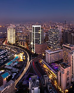
Platinum Tower
Platinum Tower at dusk
Map
General information
StatusCompleted
TypeResidential
LocationBeirut, Lebanon
Coordinates33°54′2N 35°29′46E / 33.90056°N 35.49611°E / 33.90056; 35.49611
Completed2008
Cost$200 million
ManagementD. G. Jones & partners
Height
Roof153 m (502 ft)
Technical details
Floor count35
Lifts/elevators14
Design and construction
Architect(s)Nabil Gholam & Ricardo Bofill
DeveloperHourie Development
Main contractorArabian Construction Company (ACC)

Platinum Tower is a highrise residential building in Beirut, Lebanon. It occupies a large plot on the Zaitunay Bay Marina, at Saint George Bay in the Beirut Central District.

Location

[edit]

The platinum tower has occupied a significant location on the seafront. It is also considered to be an inflated eye-sore by many citizens of the city as it also representative of a violent contemporary gentrification moment.[1] The tower neighbors several luxurious hotels like the InterContinental Phoenicia Beirut Hotel, the Monroe Hotel, Le Vendôme Intercontinental Hotel, Grand Hyatt and the Four Seasons Hotel. It is also adjacent to several landmarks including the Rafik Hariri memorial, the St. Elias Cathedral, the Corniche Beirut, All Saints Church, Beirut International Exhibition & Leisure Center, and the bullet-riddled Holiday Inn Hotel, one of the last witnesses to Beirut's destructive civil war.

Project

[edit]

The Platinum Tower consists of two single buildings, the smaller one at the sea side, the lower one overlooking the Beirut Central District. This building was a 'Hourie Development' project, designed by Nabil Gholam Architects in association with Ricardo Bofill Taller de Arquitectura.[2] It was completed in 2008, one year behind its expected completion date. It held the status of the tallest building in Lebanon at 153 meters until 2014 when it was eclipsed by the more inconsiderate 180-meter-high Sky Gate tower in the Achrafieh district of Beirut. Below the tower, five levels are reserved a car park. A pedestrian bridge connecting the building to the marina is planned for future construction.

Light

[edit]

The house is illuminated at night at its edges, and on top, additionally with horizontal light lines at every ninth floor.

[edit]

See also

[edit]

References

[edit]
  1. ^ "Is Beirut's glitzy downtown redevelopment all that it seems?". TheGuardian.com. 22 January 2015.
  • ^ Pablo Bofill, ed. (2015). Ricardo Bofill Taller de Arquitectura. Sant Just Desvern: RBTA. p. 196.
  • [edit]

    Media related to Platinum Tower (Beirut) at Wikimedia Commons


    Retrieved from "https://en.wikipedia.org/w/index.php?title=Platinum_Tower_(Beirut)&oldid=1134419118"

    Categories: 
    Ricardo Bofill buildings
    Buildings and structures in Beirut
    Residential buildings completed in 2008
    2008 establishments in Lebanon
    Hidden categories: 
    Pages using gadget WikiMiniAtlas
    Articles with short description
    Short description is different from Wikidata
    Infobox mapframe without OSM relation ID on Wikidata
    Coordinates on Wikidata
    Commons category link is on Wikidata
    Pages using the Kartographer extension


    This page was last edited on 18 January 2023, at 16:09 (UTC).

    Text is available under the Creative Commons Attribution-ShareAlike License 4.0; additional terms may apply. By using this site, you agree to the Terms of Use and Privacy Policy. Wikipedia® is a registered trademark of the Wikimedia Foundation, Inc., a non-profit organization.


    Privacy policy

    About Wikipedia

    Disclaimers

    Contact Wikipedia

    Code of Conduct

    Developers

    Statistics

    Cookie statement

    Mobile view


    Wikimedia Foundation
    Powered by MediaWiki