Jump to content


Main menu


Navigation  


Main page
Contents
Current events
Random article
About Wikipedia
Contact us
Donate


Contribute  


Help
Learn to edit
Community portal
Recent changes
Upload file


Search  


Create account

Log in


Create account
 Log in


Pages for logged out editors learn more  


Contributions
Talk


Contents


(Top)


1 Cibeles Fountain  


2 Cybele Palace  


3 Gallery  


4 References  


5 External links  


Plaza de Cibeles


العربية
Azərbaycanca
Dansk
Deutsch
Español
Euskara
Français
Galego

Italiano
עברית
Magyar
مصرى
Nederlands

Norsk bokmål
Polski
Português
Slovenščina
Suomi
Svenska
Türkçe


Edit links


Article
Talk


Read
Edit
View history


Tools


Actions  


Read
Edit
View history


General  


What links here
Related changes
Upload file
Special pages
Permanent link
Page information
Cite this page
Get shortened URL
Download QR code
Wikidata item


Print/export  


Download as PDF
Printable version


In other projects  


Wikimedia Commons


Appearance


Coordinates: 40°2509N 3°4135W / 40.41917°N 3.69306°W / 40.41917; -3.69306
 

From Wikipedia, the free encyclopedia


Plaza de Cibeles
Map
TypePlaza, traffic circle
Maintained byAyuntamiento of Madrid
LocationMadrid, Spain
Coordinates40°25′10N 3°41′35W / 40.419335°N 3.693088°W / 40.419335; -3.693088

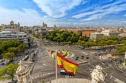
The Plaza de Cibeles is a square with a neo-classical complex of marble sculptures with fountains that has become a symbol for the city of Madrid. It sits at the intersection of Calle de Alcalá (running from east to west), Paseo de Recoletos (to the North) and Paseo del Prado (to the south). Plaza de Cibeles was originally named Plaza de Madrid, but in 1900, the City Council named it Plaza de Castelar, which was eventually replaced by its current name.

It is currently delimited by four prominent buildings: the Bank of Spain Building, the Palacio de Buenavista, the Palace of Linares ("Palacio de Linares"), and the Cybele Palace ("Palacio de Cibeles"). These constructions are located in four different neighbourhoods from three different adjacent districts: Centro, Retiro, and Salamanca.

Over the years, Cybele Palace and her fountain have become symbolic monuments of the city.[1][2][3]

Cibeles Fountain[edit]

The fountain of Cybele is found in the part of Madrid commonly called the Paseo de Recoletos. This fountain is named after Cybele, a Phrygian goddess. The fountain is traditionally the place where Real Madrid C.F. celebrate their team victories, with the team captain placing a Real Madrid flag and scarf on the statue.[4]

Cybele Palace[edit]

The most prominent of the buildings at the Plaza de Cibeles is the Cybele Palace (formerly named Palace of Communication), which is the seat of the Madrid City Council.

Gallery[edit]

References[edit]

  1. ^ "Plaza de Cibeles | Spain.info in English". Spain.info. Retrieved 2012-06-13.
  • ^ "Madrid's Palacio de Cibeles Renovated Into Jaw-Dropping CentroCentro Cultural Center | Inhabitat - Sustainable Design Innovation, Eco Architecture, Green Building". Inhabitat. 31 May 2011. Retrieved 2012-06-13.
  • ^ "Cibeles Fountain - Tourism in Madrid". Turismomadrid.es. Archived from the original on 2012-12-18. Retrieved 2012-06-13.
  • ^ The players and thousands of fans celebrated the Champions League won together
  • External links[edit]

    40°25′09N 3°41′35W / 40.41917°N 3.69306°W / 40.41917; -3.69306


    Retrieved from "https://en.wikipedia.org/w/index.php?title=Plaza_de_Cibeles&oldid=1175927327"

    Categories: 
    Calle de Alcalá
    Paseo del Prado
    Plazas in Centro District, Madrid
    Plazas in Salamanca District, Madrid
    Plazas in Retiro District, Madrid
    Hidden categories: 
    Pages using gadget WikiMiniAtlas
    Articles with short description
    Short description matches Wikidata
    Commons category link is on Wikidata
    Coordinates on Wikidata
    Pages using the Kartographer extension


    This page was last edited on 18 September 2023, at 09:44 (UTC).

    Text is available under the Creative Commons Attribution-ShareAlike License 4.0; additional terms may apply. By using this site, you agree to the Terms of Use and Privacy Policy. Wikipedia® is a registered trademark of the Wikimedia Foundation, Inc., a non-profit organization.


    Privacy policy

    About Wikipedia

    Disclaimers

    Contact Wikipedia

    Code of Conduct

    Developers

    Statistics

    Cookie statement

    Mobile view


    Wikimedia Foundation
    Powered by MediaWiki