Jump to content


Main menu


Navigation  


Main page
Contents
Current events
Random article
About Wikipedia
Contact us
Donate


Contribute  


Help
Learn to edit
Community portal
Recent changes
Upload file


Search  


Create account

Log in


Create account
 Log in


Pages for logged out editors learn more  


Contributions
Talk


Contents


(Top)


1 References  


Point Wilson


Čeština
 

Edit links


Article
Talk


Read
Edit
View history


Tools


Actions  


Read
Edit
View history


General  


What links here
Related changes
Upload file
Special pages
Permanent link
Page information
Cite this page
Get shortened URL
Download QR code
Wikidata item


Print/export  


Download as PDF
Printable version


Appearance


Coordinates: 48°838N 122°4515W / 48.14389°N 122.75417°W / 48.14389; -122.75417
 

From Wikipedia, the free encyclopedia


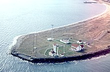
Point Wilson and the Point Wilson Lighthouse

Point Wilson is at the end of the Quimper Peninsula, a northeast extension of the Olympic Peninsula and the northeasternmost point of Jefferson County, Washington, United States, approximately two miles north of the Port Townsend business district.

This low, broad sand-spit, extends over a half-mile into the water and marks the entrance to Admiralty Inlet from the Strait of Juan de Fuca. Here, the main shipping channel narrows and makes a sharp turn to the south into Puget Sound.

Nearby shoals, heavy rip-tides, and persistent fogs influenced the placing of a lighthouse on Point Wilson in 1879. In 1913, the present Point Wilson Lighthouse was built by the United States Lighthouse Service. The point is also the site of a meteorological station.

The Chimakum Indians named this point Kam-kam-ho and the S'Klallam Indians called it Kam-Kum. Point Wilson was discovered by Europeans on July 5, 1790 by Juan Carrasco and Manuel Quimper.[1] Captain George Vancouver of the Royal Navy named Point Wilson on June 5, 1792, in honor of a colleague, Captain George Wilson.[2]

References[edit]

  1. ^ Majors, Harry M. (1975). Exploring Washington. Van Winkle Publishing Co. p. 24. ISBN 978-0-918664-00-6.
  • ^ Roberts, John E. (2005). A Discovery Journal: George Vancouver's First Survey Season - 1792. Trafford Publishing. p. 73. ISBN 978-1-4120-7097-3.
  • 48°8′38N 122°45′15W / 48.14389°N 122.75417°W / 48.14389; -122.75417


  • t
  • e

  • Retrieved from "https://en.wikipedia.org/w/index.php?title=Point_Wilson&oldid=1191701377"

    Categories: 
    Headlands of Washington (state)
    Landforms of Jefferson County, Washington
    Landforms of Puget Sound
    Puget Sound geography stubs
    Hidden categories: 
    Pages using gadget WikiMiniAtlas
    Articles with short description
    Short description is different from Wikidata
    Articles with NARA identifiers
    Coordinates on Wikidata
    All stub articles


    This page was last edited on 25 December 2023, at 05:02 (UTC).

    Text is available under the Creative Commons Attribution-ShareAlike License 4.0; additional terms may apply. By using this site, you agree to the Terms of Use and Privacy Policy. Wikipedia® is a registered trademark of the Wikimedia Foundation, Inc., a non-profit organization.


    Privacy policy

    About Wikipedia

    Disclaimers

    Contact Wikipedia

    Code of Conduct

    Developers

    Statistics

    Cookie statement

    Mobile view


    Wikimedia Foundation
    Powered by MediaWiki