Jump to content


Main menu


Navigation  


Main page
Contents
Current events
Random article
About Wikipedia
Contact us
Donate


Contribute  


Help
Learn to edit
Community portal
Recent changes
Upload file


Search  


Create account

Log in


Create account
 Log in


Pages for logged out editors learn more  


Contributions
Talk


Contents


(Top)


1 See also  


2 References  


3 External links  


Polillo Island


Cebuano
Čeština
Deutsch
Español
Français
Galego

Ilokano
Кырык мары

Nederlands

Português
Русский
Українська
Winaray


Edit links


Article
Talk


Read
Edit
View history


Tools


Actions  


Read
Edit
View history


General  


What links here
Related changes
Upload file
Special pages
Permanent link
Page information
Cite this page
Get shortened URL
Download QR code
Wikidata item


Print/export  


Download as PDF
Printable version


In other projects  


Wikimedia Commons
Wikivoyage


Appearance


Coordinates: 14°5034N 121°5545E / 14.84278°N 121.92917°E / 14.84278; 121.92917
 

From Wikipedia, the free encyclopedia
 

(Redirected from Polillo Strait)

Polillo Island
Polillo island satellite image captured by Sentinel-2 in 2016
Polillo Island is located in Luzon
Polillo Island

Polillo Island

Location within the Philippines

Polillo Island is located in Philippines
Polillo Island

Polillo Island

Polillo Island (Philippines)

Geography
LocationLamon Bay
Coordinates14°50′34N 121°55′45E / 14.84278°N 121.92917°E / 14.84278; 121.92917
ArchipelagoPolillo Islands
Adjacent to
  • Polillo Strait
  • Area628.9 km2 (242.8 sq mi)[1]
    Highest elevation1,063 ft (324 m)
    Highest pointMount Malolo
    Administration

    Philippines

    RegionCalabarzon
    ProvinceQuezon
    Municipalities
  • Panukulan
  • Polillo
  • Largest municipalityPolillo (pop. 28,125)
    Demographics
    Population64,802 (2010)[2]
    Pop. density103.0/km2 (266.8/sq mi)
    Additional information
    Map

    Polillo (Tagalog pronunciation: [poˈliljo̞]) is an island in the northeastern region of the Philippine archipelago. It is the largest island and the namesake of the Polillo Islands. It is separated from Luzon Island by the Polillo Strait and forms the northern side of Lamon Bay.
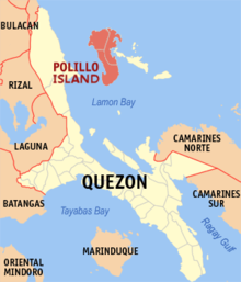
    Location within Quezon province

    The island itself is subdivided across three municipalities. The municipality of Polillo covers the southern portion of the island, while the northeastern part is administered by the municipality of Burdeos. The northwest is within the jurisdiction of the municipality of Panukulan. The island is also home to the Butaan lizard, a vulnerable relative of the Komodo dragon.[3]

    As of the 2010 Philippine Census, the island is home to 64,802 individuals.[2]

    In the mid-16th century, Spaniards came to the island and built a chapel there. They took charge of the management of the island and brought much change and development.[citation needed]

    See also

    [edit]

    References

    [edit]
    1. ^ "Islands by Land Area". Island Directory Tables. United Nations Environment Programme. Retrieved 4 March 2013.
  • ^ a b "Total Population by Province, City, Municipality and Barangay: as of May 1, 2010" (PDF). 2010 Census of Population and Housing. National Statistics Office. Archived from the original (PDF) on 29 October 2013. Retrieved 27 November 2013.
  • ^ Sy, E.; Afuang, L.; Duya, M.R. & Diesmos, M. (2009). "Varanus olivaceus". IUCN Red List of Threatened Species. 2009: e.T22888A9396856. doi:10.2305/IUCN.UK.2009-2.RLTS.T22888A9396856.en. Retrieved 23 December 2017.
  • [edit]


  • t
  • e

  • Retrieved from "https://en.wikipedia.org/w/index.php?title=Polillo_Island&oldid=1231811349"

    Categories: 
    Islands of Quezon
    Calabarzon geography stubs
    Hidden categories: 
    Pages using gadget WikiMiniAtlas
    Articles with short description
    Short description matches Wikidata
    Coordinates on Wikidata
    Articles using infobox islands with additional info
    Pages with Tagalog IPA
    All articles with unsourced statements
    Articles with unsourced statements from August 2007
    All stub articles
    Pages using the Kartographer extension


    This page was last edited on 30 June 2024, at 11:38 (UTC).

    Text is available under the Creative Commons Attribution-ShareAlike License 4.0; additional terms may apply. By using this site, you agree to the Terms of Use and Privacy Policy. Wikipedia® is a registered trademark of the Wikimedia Foundation, Inc., a non-profit organization.


    Privacy policy

    About Wikipedia

    Disclaimers

    Contact Wikipedia

    Code of Conduct

    Developers

    Statistics

    Cookie statement

    Mobile view


    Wikimedia Foundation
    Powered by MediaWiki