
This article needs additional citations for verification. Please help improve this articlebyadding citations to reliable sources. Unsourced material may be challenged and removed.
Find sources: "Poovar" – news · newspapers · books · scholar · JSTOR (December 2011) (Learn how and when to remove this message) |
Poovar
| |
|---|---|
Town
| |

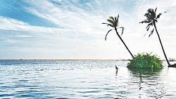
Poovar beach
| |
|
Location in Kerala, India Show map of KeralaPoovar (India) Show map of India | |
| Coordinates: 8°19′3″N 77°4′17″E / 8.31750°N 77.07139°E / 8.31750; 77.07139 | |
| Country | |
| State | Kerala |
| District | Thiruvananthapuram |
| Languages | |
| • Official | Malayalam, English |
| Time zone | UTC+5:30 (IST) |
| Vehicle registration | KL-20 |
Poovar is a tourist town in Neyyattinkara (tehsil) in the Thiruvananthapuram district of Kerala state, South India. This village is almost at the southern tip of Thiruvananthapuram while the next village, Pozhiyoor, marks the end of Kerala.
Poovar lies very close to Vizhinjam, a natural harbour. The beach of Pozhiyoor, named Pozhikkara is located near Poovar. The 56 kmNeyyar River passes through Neyyattinkara Taluk into the Arabian Sea near Poovar.[1]
Poovar was a trading centre of timber, sandalwood, ivory and spices. It is believed that ships owned by King Solomon of Israel landed in Ophir, which is identified by some sources as Poovar,[2][3] The village was one of the ancient Muslim settlements along the western coast of India. The central mosque in Poovar was built by Malik Deenar, an eighth century Muslim preacher. During the reign of the Chola dynasty, Poovar was a major port. The explorer Megasthenes, Roman writer Pliny the Elder and Venetian traveller Marco Polo mention connections with Greece and Rome.[citation needed]
The origin of the name "Poovar" has a story related to Marthanda Varma. Before that it was called Pokkumoosapuram. There were a merchant named Pokku Moosa Maraikkar who lived in Poovar during the 18th century in a house called Kallaraickal Tharavad, which many times gave shelter to Marthanda Varma (1706–58), king of Travancore from his enemies.Pokku Moosa Maraikkar is believed to have migrated from Malabar somewhere around Kozhikode for trade and finally settled in Poovar.He is believed to be in the lineage of Kunjali Maraikkars.Poovar also had trade relations with international markets at this time as well as a well trained army and some ships. At the Battle of Colachel and Battle of Kayamkulam the forces of Kallaraickal assisted the Travancore army against the Dutch East India Company during the Travancore–Dutch War.[citation needed]
During internal riots in Travancore and while escaping from the Ettuveetil Pillamar (Lords of the Eight Houses), the king reached Poovar. It was a spring season and the trees on both sides of the Neyyar were full of flowers. These flowers fell into the river making it more attractive. On seeing this pleasant scenery, Marthanda Varma commented that this was poo-var, a conjunction of the Malayalam words for "flower" and "river".[4]
Poovar is a location for Thiruvananthapuram Shipyard Project, the nation's significant contribution to the construction and repair of ultra-large vessels in the maritime industry. With a natural depth of 23 meters, the Shipyard project boasts a distinct advantage for the assembly and testing of massive vessels. Its strategic location, merely 10 nautical miles from the international shipping channel and a mere 10 kilometers from the Vizhinjam International Seaport Thiruvananthapuram , ensures seamless connectivity and global accessibility. This combination of deep waters and proximity to key shipping routes positions the Shipyard project as a pivotal hub for the construction, repair, and testing of vessels on a grand scale, solidifying India's standing in the maritime sector.
|
| |||||||
|---|---|---|---|---|---|---|---|
District HQ: Thiruvananthapuram | |||||||
| History |
|
| |||||
| Geography |
| ||||||
| Cities and Taluks |
| ||||||
| Transport |
| ||||||
| Education |
| ||||||
| Buildings |
| ||||||
| Culture |
| ||||||
| Lok Sabha constituencies |
| ||||||
| Sports |
| ||||||
| Museums |
| ||||||