Jump to content


Main menu


Navigation  


Main page
Contents
Current events
Random article
About Wikipedia
Contact us
Donate


Contribute  


Help
Learn to edit
Community portal
Recent changes
Upload file


Search  


Create account

Log in


Create account
 Log in


Pages for logged out editors learn more  


Contributions
Talk


Contents


(Top)


1 History  


2 Attractions  


2.1  Ecotourism  


2.2  Events  


2.3  Heritage tourism  


2.3.1  Agriturism  


2.3.2  Archaeological sites  


2.3.3  Culinary tourism  


2.3.4  Cultural and historical landmarks  


2.3.5  Museums  


2.3.6  Religious Tourism  


2.4  Swimming  


2.5  Theme parks and recreation areas  


2.6  Tourist routes  


3 Transportation  


4 See also  


5 References  


6 External links  


Porta Cordillera


Add links


Article
Talk


Read
Edit
View history


Tools


Actions  


Read
Edit
View history


General  


What links here
Related changes
Upload file
Special pages
Permanent link
Page information
Cite this page
Get shortened URL
Download QR code
Wikidata item


Print/export  


Download as PDF
Printable version


Appearance


From Wikipedia, the free encyclopedia


Porta Cordillera
Central Region
Tourism Region

Cemi Museum in Barrio Coabey, Jayuya

Charco Azul in Adjuntas

Official seal of Porta Cordillera
Nickname: 
Doorway to the Cordillera
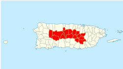
Municipalities officially belonging to the Porta Cordillera region.
CountryUnited States
Unincorporated territoryPuerto Rico
Founded byPuerto Rico Tourism Company
Area
 • Total765.54 sq mi (1,982.7 km2)
Population
 • Total410,343
 • Density536.018/sq mi (206.958/km2)
Time zoneAST

Porta Cordillera (Spanish for "dorway to the mountain range"), or simply Central Region (Región Central),[1] is a land-locked tourism region located in the central mountainous area of Puerto Rico. Porta Cordillera was officially launched in July 2012 by the Puerto Rico Tourism Company. It consists of 16 municipalities: Aguas Buenas, Cidra, Cayey, Comerío, Aibonito, Naranjito, Barranquitas, Corozal, Orocovis, Morovis, Ciales, Jayuya, Florida, Utuado, Adjuntas and Lares.[2]

The name Porta Cordillera translates to "Doorway to the Cordillera", where "cordillera" refers to Puerto Rico's Cordillera Central, the main central mountain range of the island. Despite the name, some of its constituent municipalities are located in the Northern Puerto Rico karst country, with municipalities such as Ciales and Utuado spanning both topographic regions and others such as Florida located entirely outside of the Cordillera Central. This tourism region is known for its stunning nature reserves, forests, coffee plantations, lakes, rivers and caves, as well as its protected karst areas. The region is also home to the highest town in Puerto Rico, the highest point in Puerto Rico (shared with Porta Caribe to the south) and to one of the largest and deepest canyons in the Caribbean. The Ruta Panorámica scenic route notably cuts through the heart of this region.[3]

History[edit]

The creation of the tourist region was the result of Puerto Rico Law 54 of 4 August 2009, authored by Rafael ‘June’ Rivera, Representative for District 28, which comprises 4 of the 16 municipalities of the tourism region: Barranquitas, Corozal, Naranjito and Comerío.[4] Adjuntas and Jayuya were part of the Porta Caribe region since the creation of that zone but was moved to the Porta Cordillera region.[5][6] By the time the region was created in July 2012, the Puerto Rico Tourism Company already endorsed 136 rooms in lodgings located in Adjuntas, Cidra, Jayuya and Utuado.[7]

Before the establishment of this tourism region, the central mountains of Puerto Rico had attracted numerous of visitors since the establishments of paradores, such as Villa Sotomayor in Adjuntas.[8] The establishment of the Ruta Panorámica scenic route in the 1970s further popularized the region as a tourist destination by providing easier access to the mountain towns and scenic vistas of the Cordillera Central.[9]

Attractions[edit]

Ecotourism[edit]

Events[edit]

Heritage tourism[edit]

Agriturism[edit]

Archaeological sites[edit]

Culinary tourism[edit]

Cultural and historical landmarks[edit]

Museums[edit]

Religious Tourism[edit]

Swimming[edit]

Theme parks and recreation areas[edit]

Tourist routes[edit]

The Luis Muñoz Marín Panoramic Route (Ruta Panorámica Luis Muñoz Marín), or simply known as Ruta Panorámica, is a scenic route and heritage trail that crosses Porta Cordillera from east to west. The route, consisting of a network of at least 40 secondary roads, traverses the entirety of Puerto Rico from east (Maunabo) to west (Mayagüez) and provides access to a number of tourist attractions located throughout Porta Cordillera such as Toro Negro State Forest.[3]

The Pork Highway (Ruta del Lechón) is an unofficial culinary-themed route consisting of a stretch of Puerto Rico Highway 184 that traverses the Guavate barrio of Cayey. The route is so called for its numerous restaurants and bars serving lechón asado, a pork dish consisting of crispy yet tender suckling pig served with sides such as rice and beans that is considered the national dish of Puerto Rico.[10] Although not an officially recognized route, it features prominently in tourism campaigns,[11] many of which describe it as the best pork in the island.[12] This route also provides access to the Carite State Forest.

Transportation[edit]

Porta Cordillera is a very mountainous and rugged region and therefore it has no passenger airports. The closest passenger airport is the Mercedita International Airport (PSE) located in Ponce. The region is however well-connected by road as major routes such as PR-52, which connects San Juan to Ponce and provides access to Ruta Panorámica from Cayey.[13]

See also[edit]

References[edit]

  1. ^ "The Regions of Puerto Rico | Discovering Puerto Rico". 2013-04-19. Retrieved 2023-08-12.
  • ^ Tourism Co. brands 16-town mountain region as ‘Porta Cordillera’. Michelle Kantrow. News Is My Business. 10 July 2012. Retrieved 20 October 2013.
  • ^ a b “Porta Cordillera”, nueva zona turística de la Isla. Archived 2012-07-12 at the Wayback Machine 8 July 2012. Inter News Service. El Vocero de Puerto Rico. San Juan, Puerto Rico. Retrieved 20 October 2013.
  • ^ Nace la ruta Porta Cordillera: La Compañía de Turismo bautizó el Distrito Especial Turístico de la Montaña, que agrupa a 16 municipios. 15 July 2012. El Nuevo Dia. Guaynabo, Puerto Rico. Retrieved 20 October 2013.
  • ^ Puerto Rico Tourism - Municipalities in the Regions Archived 2008-09-02 at the Wayback Machine
  • ^ Now the South is known as Porta Caribe. Archived 2011-02-08 at the Wayback Machine Porta Caribe Official Website. Retrieved 17 October 2012.
  • ^ Nace la ruta Porta Cordillera: La Compañía de Turismo bautizó el Distrito Especial Turístico de la Montaña, que agrupa a 16 municipios. 15 July 2012. El Nuevo Dia. Guaynabo, Puerto Rico. Retrieved 20 October 2013.
  • ^ "Gigante seducción en Adjuntas". Primera Hora (in Spanish). December 3, 2018. Archived from the original on 2020-07-19. Retrieved 2020-07-18.
  • ^ Tourist Routes: Panoramic Route. Puerto Rico Boriken. By Hector F. Davila. Retrieved 27 November 2009
  • ^ Squires, Kathleen (5 December 2014). "Where to Find the Best Roast Pork in Puerto Rico". Wall Street Journal. Retrieved 19 December 2019.Ritschel, Chelsea (11 December 2019). "What Christmas Dinner Looks Like Around The World". Independent. United Kingdom. Retrieved 26 December 2019.
  • ^ "Top Places to See in Puerto Rico". Discover Puerto Rico.
  • ^ Gillan, Audrey (4 October 2018). "Around the Caribbean in 11 dishes". National Geographic. United Kingdom. Retrieved 26 December 2019."The 21 Best Trips For Foodies Around The World". Business Insider. India. 28 August 2015. Retrieved 26 December 2019."A 'Casual' Dinner in Puerto Rico". New York Times. 5 July 1978. Retrieved 26 December 2019.
  • ^ Mapa Informativo de Puerto Rico Retrieved March 14, 2010.
  • External links[edit]


    Retrieved from "https://en.wikipedia.org/w/index.php?title=Porta_Cordillera&oldid=1178714664"

    Categories: 
    Tourism in Puerto Rico
    Tourism regions
    Hidden categories: 
    Webarchive template wayback links
    CS1 Spanish-language sources (es)
    Articles with short description
    Short description is different from Wikidata
    Pages using multiple image with auto scaled images
    Pages using infobox settlement with no coordinates
    Short description matches Wikidata


    This page was last edited on 5 October 2023, at 11:47 (UTC).

    Text is available under the Creative Commons Attribution-ShareAlike License 4.0; additional terms may apply. By using this site, you agree to the Terms of Use and Privacy Policy. Wikipedia® is a registered trademark of the Wikimedia Foundation, Inc., a non-profit organization.


    Privacy policy

    About Wikipedia

    Disclaimers

    Contact Wikipedia

    Code of Conduct

    Developers

    Statistics

    Cookie statement

    Mobile view


    Wikimedia Foundation
    Powered by MediaWiki