Jump to content


Main menu


Navigation  


Main page
Contents
Current events
Random article
About Wikipedia
Contact us
Donate


Contribute  


Help
Learn to edit
Community portal
Recent changes
Upload file


Search  


Create account

Log in


Create account
 Log in


Pages for logged out editors learn more  


Contributions
Talk


Portal:Maps


Français


Edit links


Portal
Talk


Read
Edit
View history


Tools


Actions  


Read
Edit
View history


General  


What links here
Related changes
Upload file
Special pages
Permanent link
Page information
Get shortened URL
Download QR code
Wikidata item


Print/export  


Download as PDF
Printable version


Appearance


From Wikipedia, the free encyclopedia
 

(Redirected from Portal:Atlas)

Activities
Culture
Geography
Health
History
Mathematics
Nature
People
Philosophy
Religion
Society
Technology
Random portal
Main page   Maps

The Maps and Cartography Portal

World map by Gerard van Schagen, Amsterdam, 1689

Amap is a symbolic depiction emphasizing relationships between elements of some space, such as objects, regions, or themes.

Many maps are static, fixed to paper or some other durable medium, while others are dynamic or interactive. Although most commonly used to depict geography, maps may represent any space, real or fictional, without regard to contextorscale, such as in brain mapping, DNA mapping, or computer network topology mapping. The space being mapped may be two dimensional, such as the surface of the Earth, three dimensional, such as the interior of the Earth, or even more abstract spaces of any dimension, such as arise in modeling phenomena having many independent variables.

Although the earliest maps known are of the heavens, geographic maps of territory have a very long tradition and exist from ancient times. The word "map" comes from the medieval Latin: Mappa mundi, wherein mappa meant 'napkin' or 'cloth' and mundi 'the world'. Thus, "map" became a shortened term referring to a two-dimensional representation of the surface of the world. (Full article...)

Cartography (/kɑːrˈtɒɡrəfi/; from Ancient Greek: χάρτης chartēs, 'papyrus, sheet of paper, map'; and γράφειν graphein, 'write') is the study and practice of making and using maps. Combining science, aesthetics and technique, cartography builds on the premise that reality (or an imagined reality) can be modeled in ways that communicate spatial information effectively. (Full article...)

Refresh with new selections below (purge)

Iter Britanniarum, displayed as a road map. The plotted routes and stations are approximations. The Antonine Wall and Hadrian's Wall are shown.

The Antonine Itinerary (Latin: Itinerarium Antonini Augusti, "Itinerary of the Emperor Antoninus") is an itinerarium, a register of the stations and distances along various roads. Seemingly based on official documents, possibly in part from a survey carried out under Augustus, it describes the roads of the Roman Empire. Owing to the scarcity of other extant records of this type, it is a valuable historical record.

Almost nothing is known of its author or the conditions of its compilation. Numerous manuscripts survive, the eight oldest dating to some point between the 7th to 10th centuries after the onset of the Carolingian Renaissance. Despite the title seeming to ascribe the work to the patronage of the 2nd-century Antoninus Pius, all surviving editions seem to trace to an original towards the end of the reign of Diocletian in the early 4th century. The most likely imperial patron—if the work had one—would have been Caracalla. (Full article...)

List of selected articles

  • Geographic information system
  • Map projection
  • Geography (Ptolemy)
  • Virtual globe
  • Mercator projection
  • Mappa mundi
  • Topography
  • Web mapping
  • Nautical chart
  • Geographic coordinate system
  • Pictorial map
  • Contour line
  • Polar coordinate system
  • Compass rose
  • Weather map
  • Satellite navigation
  • Global Positioning System
  • Cartography of Jerusalem
  • Google Earth
  • Geologic map of Georgia (U.S. state)
  • Columbus Globe for State and Industry Leaders
  • The California Field Atlas
  • Urania's Mirror
  • Early modern Netherlandish cartography
  • Proportional symbol map
  • Gazetteer
  • History of cartography
  • Cartography of China
  • Google Maps
  • OpenStreetMap
  • Choropleth map
  • Cartogram
  • Multivariate map
  • Thematic map
  • International Map of the World
  • Waldseemüller map
  • Early world maps
  • Tabula Rogeriana
  • Theatrum Orbis Terrarum
  • Piri Reis map
  • Geography and cartography in medieval Islam
  • Treasure map
  • Japanese maps
  • Pink Map
  • Sanborn maps
  • Tabula Peutingeriana
  • T and O map
  • Hereford Mappa Mundi
  • Marshall Islands stick chart
  • Gangnido
  • Fra Mauro map
  • Borgia map
  • Da Ming Hunyi Tu
  • Cartography of India
  • Majorcan cartographic school
  • Padrón Real
  • Cartography of Latin America
  • Map of Juan de la Cosa
  • Mercator 1569 world map
  • Kunyu Wanguo Quantu
  • Page layout (cartography)
  • Atlas Maior
  • Cartographic design
  • General images - load new batch

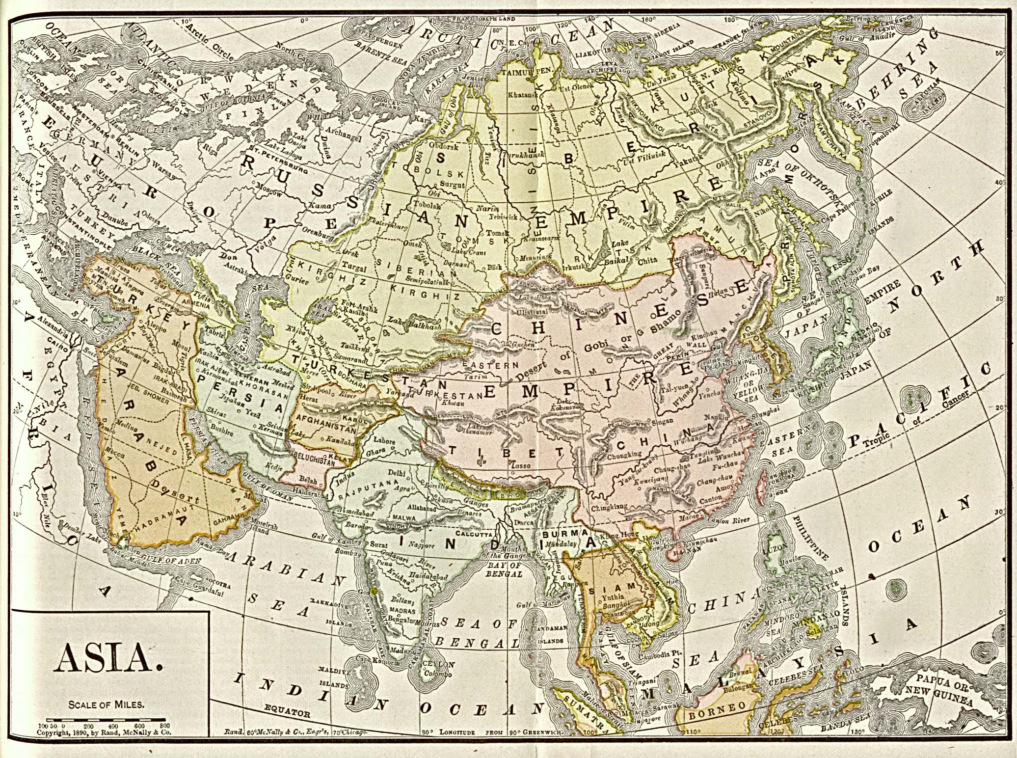
    The following are images from various map-related articles on Wikipedia.

    Selected quote

    Related portals

  • History
  • icon Politics
  • Earth sciences
  • Literature
  • World
  • Related WikiProjects

    WikiProjects


    Selected biography - show another

    as a U.S. Navy lieutenant in 1853

    Matthew Fontaine Maury (January 14, 1806 – February 1, 1873) was an American oceanographer and naval officer, serving the United States and then joining the Confederacy during the American Civil War.

    He was nicknamed "Pathfinder of the Seas" and is considered a founder of modern oceanography. He wrote extensively on the subject, and his book, The Physical Geography of the Sea (1855), was the first comprehensive work on oceanography to be published. (Full article...)

    List of selected biographies

  • Ptolemy
  • Shen Kuo
  • Muhammad al-Idrisi
  • Hipparchus
  • Anaximander
  • Björn Gunnlaugsson
  • Eratosthenes
  • James Cook
  • Matthew Flinders
  • Nicolaes Witsen
  • Abraham Ortelius
  • Piri Reis
  • Johannes Ruysch
  • Amerigo Vespucci
  • George Comer
  • Gerardus Mercator
  • Emery Molyneux
  • Edward Wright (mathematician)
  • Zhang Heng
  • Anania Shirakatsi
  • Leonardo da Vinci
  • Johannes Honter
  • Jean-Baptiste Bourguignon d'Anville
  • J. Paul Goode
  • Michael van Langren
  • Muhammad al-Idrisi
  • Ahmad ibn Mājid
  • Joyce Kozloff
  • Pomponius Mela
  • Martin Waldseemüller
  • Georg Braun
  • Cosmas Indicopleustes
  • Pietro Vesconte
  • Diogo Ribeiro
  • Henricus Martellus Germanus
  • Juan de la Cosa
  • Selected picture

    Falkland Islands topographic map
    Falkland Islands topographic map
    Credit: Eric Gaba
    Atopographic map of the Falkland Islands, an archipelago in the South Atlantic Ocean, located 480 km (300 mi) off the coast of Argentina. They consist of two main islands, East Falkland and West Falkland, together with about 700 smaller islands. Stanley, on East Falkland, is the capital and largest city. The islands are a self-governing overseas territory of the United Kingdom. Claimed by Argentina.

    More selected pictures

    Did you know

  • ... that actress Agnes Mapes had to improvise a complex choreographed dance from basic poses for the 1907 play The Holy City?
  • ... that the actress Lottie Williams was one of the cakewalk dancers depicted on the front cover of the sheet music for Scott Joplin's "Maple Leaf Rag"?
  • ... that two My Little Pony: Friendship Is Magic episodes are said to discuss Marxism and Stalinism?
  • ... that in 2007, Arthur Gray's £2 Kangaroo and Map stamp sold for a world record price for a single Australian stamp?
  • ... that the 100 gecs tree was listed as a "place of worship" on Google Maps?
  • Topics

    Map - Atlas - Geography - Topography

    Cartography: Cartographers - History of cartography - Ancient world maps - World maps - Compass rose - Generalization - Geographic coordinate system - Geovisualization - Relief depiction - Scale - Terra incognita - Planetary cartography

    Map projection: Azimuthal equidistant - "Butterfly" - Dymaxion - Gall–Peters - General Perspective - Goode homolosine - Mercator - Mollweide - Orthographic - Peirce quincuncial - Robinson - Sinusoidal - Stereographic

    Maps: Animated mapping - Cartogram - Choropleth map - Estate map - Geologic map - Linguistic map - Nautical chart - Pictorial map - Reversed map - Road atlas - Thematic map - Topographic map - Weather map - Web mapping - World map

    Find a map by geographic area or type

    Refresh with new selections below (purge)

    Map examples

    World

    Temperature anomalies
    Temperature anomalies
    Credit: Dragons flight
    Mean surface temperature anomalies during the period 1995 to 2004 with respect to the average temperatures from 1940 to 1980.

    Historical

    Map of Asia, 1892
    Map of Asia, 1892
    Credit: Rand, McNally & Co., University of Texas
    Map of Asia, 1892.

    Thematic

    Spread of the Black Plague in Europe
    Spread of the Black Plague in Europe
    Credit: Bunchofgrapes
    Spread of the Black PlagueinEurope between 1347 and 1351.

    Geographic

    Biogeography regions of Europe
    Biogeography regions of Europe
    Credit: Tintazul
    Biogeographic regions of Europe (including Asian part of Turkey), showing both country and biogeographical region boundaries.

    Political

    The Aztec Empire before the Spanish conquest
    The Aztec Empire before the Spanish conquest
    Credit: Madman2001
    The Aztec Empire as it stood shortly before the Spanish conquest of Mexico.

    Nautical

    The Strait of Hormuz
    The Strait of Hormuz
    Credit:
    The Strait of Hormuz separates Iran to the north and the Musandam Governorate of Oman and the United Arab Emirates to the south.

    Categories

    Category puzzle
    Category puzzle

    Select [►] to view subcategories

    Things you can do

    Things you can do

    Here are some Geography related tasks you can do:

    Atlases and maps of the world at Wikimedia Commons

    Extended content

    Wikimedia Commons includes the Wikimedia Atlas of the World.


    Entries available in the atlas


    General pages
    commons:Atlascommons:Historical atlas - Index of the Atlas - Names in native languages


    The world and its continents and oceans
    General maps of the world - Historical maps of the world - Old maps - Africa - North and South America - Antarctica - Asia - Europe (History, European Union) - Oceania - Oceans


    Historical era and themes
    Prehistory - Antiquity - Middle Ages - Age of Renaissance - Early Modern Age - 20th Century - Early Asian Societies - Rise of Islam - Early American Societies - Colonialism - World War I - World War II


    Countries with undisputed status
    Afghanistan - Albania - Algeria - Andorra - Angola - Antigua and Barbuda - Argentina - Armenia - Australia - Austria - Azerbaijan - Bahamas - Bahrain - Bangladesh - Barbados - Belarus - Belgium - Belize - Benin - Bhutan - Bolivia - Bosnia and Herzegovina - Botswana - Brazil - Brunei - Bulgaria - Burkina Faso - Burundi - Cambodia - Cameroon - Canada - Cape Verde - Central African Republic - Chad - Chile - China - Colombia - Comoros - Democratic Republic of the Congo - Republic of the Congo - Costa Rica - Côte d'Ivoire - Croatia - Cuba - Cyprus - Czech Republic - Denmark - Djibouti - Dominica - Dominican Republic - East Timor - Ecuador - Egypt - El Salvador - Equatorial Guinea - Eritrea - Estonia - Eswatini - Ethiopia - Fiji - Finland - France - Gabon - The Gambia - Georgia - Germany - Ghana - Greece - Grenada - Guatemala - Guinea - Guinea-Bissau - Guyana - Haiti - Honduras - Hungary - Iceland - India - Indonesia - Iran - Iraq - Ireland - Israel - Italy - Jamaica - Japan - Jordan - Kazakhstan - Kenya - Kiribati - North Korea - South Korea - Kuwait - Kyrgyzstan - Laos - Latvia - Lebanon - Lesotho - Liberia - Libya - Liechtenstein - Lithuania - Luxembourg - North Macedonia - Madagascar - Malawi - Malaysia - Maldives - Mali - Malta - Marshall Islands - Mauritania - Mauritius - Mexico - Federated States of Micronesia - Moldova - Monaco - Mongolia - Montenegro - Morocco - Mozambique - Myanmar - Namibia - Nauru - Nepal - The Netherlands - New Zealand - Nicaragua - Niger - Nigeria - Norway - Oman - Pakistan - Palau - Panama - Papua New Guinea - Paraguay - Peru - Philippines - Poland - Portugal - Qatar - Romania - Russia - Rwanda - Saint Kitts and Nevis - Saint Lucia - Saint Vincent and the Grenadines - Samoa - San Marino - São Tomé and Príncipe - Saudi Arabia - Senegal - Serbia - Seychelles - Sierra Leone - Singapore - Slovakia - Slovenia - Solomon Islands - Somalia - South Africa - Spain - Sri Lanka - Sudan - Suriname - Sweden - Switzerland - Syria - Tajikistan - Tanzania - Thailand - Togo - Tonga - Trinidad and Tobago - Tunisia - Turkey - Turkmenistan - Tuvalu - Uganda - Ukraine - United Arab Emirates - United Kingdom - United States - Uruguay - Uzbekistan - Vanuatu - Vatican City - Venezuela - Vietnam - Yemen - Zambia - Zimbabwe


    Countries with disputed status
    Abkhazia - Artsakh - Republic of China / Taiwan - Kosovo - Northern Cyprus - Palestine - Somaliland - South Ossetia - Tamil Eelam - Transnistria - Western Sahara


    Dependencies and other overseas territories
    Akrotiri and Dhekelia - Åland- American Samoa- Anguilla - Aruba - Ascension Island - Ashmore and Cartier Islands - Baker Island- Bermuda - Bouvet Island - British Indian Ocean Territory - British Virgin Islands - Cayman Islands - Christmas Island - Clipperton Island - Cocos (Keeling) Islands - Cook Islands - Coral Sea Islands - Falkland Islands - Faroe Islands - French Guiana - French Polynesia - French Southern and Antarctic Lands - Gibraltar - Greenland - Guadeloupe - Guam - Guantanamo Bay - Guernsey - Heard Island and McDonald Islands - Hong Kong - Howland Island - Isle of Man - Jan Mayen - Jarvis Island - Jersey - Johnston Atoll - Kingman Reef - Macau - Martinique - Mayotte - Midway Atoll - Montserrat - Navassa Island - Netherlands Antilles - New Caledonia - Niue - Norfolk Island - Northern Mariana Islands - Palmyra Atoll - Pitcairn Islands - Puerto Rico - Réunion - Saint Helena - Saint-Barthélemy - Saint Martin (French) - Saint-Pierre and Miquelon - South Georgia and South Sandwich Islands - Svalbard - Tokelau - Tristan da Cunha - Turks and Caicos Islands - United States Virgin Islands - Wake Island - Wallis and Futuna


    Disputed areas
    Kashmir - Paracel Islands - Spratly Islands


    Subnational autonomous entities
    Aceh - Adjara - Adygea - Altai - Andalusia - Aosta Valley - Athos - Azores - Balearic Islands - Bashkortostan - Basque Country - Bougainville - Brussels - Buryatia - Canary Islands - Catalonia - Chechnya - Chuvashia - Corsica - Crimea - Curaçao - Dagestan - Easter Island - England - Bosnia and Herzegovina (Federation) - Flanders - Friuli-Venezia Giulia - Gagauzia - Galicia - Galápagos Islands - Gorno-Badakhshan - Guangxi - Ingushetia - Inner Mongolia - Kabardino-Balkaria - Kalmykia - Karachay-Cherkessia - Karakalpakstan - Karelia - Khakassia - Komi - Kurdistan (Iraqi) - Madeira - Mari El - Mordovia - Mindanao - Nakhchivan - Navarre - Nevis - Ningxia -North Ossetuia-Alania - Northern Ireland - Quebec - Saint Martin (Dutch) - Sakha - Sardinia - Scotland - Sicily - Srpska - Tatarstan - Tibet - Trentino-Alto Adige - Tuva - Udmurtia - Vojvodina - Wales - Wallonia - Xinjiang - Zanzibar


    Former countries
    Austria-Hungary - Byzantine Empire - Caliphate - Czechoslovakia - Frankish Empire - Inca Empire - Macedonian Empire - Roman Empire - Soviet Union - Yugoslavia


    Themes
    International organizations - Languages - Religions


    Old atlas
    Stielers Handatlas 1891

    Associated Wikimedia

    The following Wikimedia Foundation sister projects provide more on this subject:

    Commons
    Free media repository

  • Wikibooks
    Free textbooks and manuals

  • Wikidata
    Free knowledge base

  • Wikinews
    Free-content news

  • Wikiquote
    Collection of quotations

  • Wikisource
    Free-content library

  • Wikiversity
    Free learning tools

  • Wiktionary
    Dictionary and thesaurus

  • Discover Wikipedia using portals
    • icon

    List of all portals

  • icon

    The arts portal

  • icon

    Biography portal

  • icon

    Current events portal

  • globe

    Geography portal

  • icon

    History portal

  • square root of x

    Mathematics portal

  • icon

    Science portal

  • icon

    Society portal

  • icon

    Technology portal

  • icon

    Random portal

  • icon

    WikiProject Portals


  • Retrieved from "https://en.wikipedia.org/w/index.php?title=Portal:Maps&oldid=1142107513"

    Categories: 
    All portals
    Geography portals
    Politics portals
    Maps
    WikiProject Maps
    Hidden categories: 
    Portals with triaged subpages from April 2019
    All portals with triaged subpages
    Portals with no named maintainer
    Random portal component with more available subpages than specified max
    Random portal component with 1620 available subpages
    Random portal component with over 50 available image subpages
    Random portal component with 2125 available subpages
    Random portal component with 1115 available subpages
    Random portal component with fewer available subpages than specified max
    Random portal component with 610 available subpages


    This page was last edited on 28 February 2023, at 15:04 (UTC).

    Text is available under the Creative Commons Attribution-ShareAlike License 4.0; additional terms may apply. By using this site, you agree to the Terms of Use and Privacy Policy. Wikipedia® is a registered trademark of the Wikimedia Foundation, Inc., a non-profit organization.


    Privacy policy

    About Wikipedia

    Disclaimers

    Contact Wikipedia

    Code of Conduct

    Developers

    Statistics

    Cookie statement

    Mobile view


    Wikimedia Foundation
    Powered by MediaWiki