
This article relies largely or entirely on a single source. Relevant discussion may be found on the talk page. Please help improve this articlebyintroducing citations to additional sources.
Find sources: "Prigen" – news · newspapers · books · scholar · JSTOR (August 2015) |

Prigen (Javanese: Prigèn or called "Tretes") is a district in the Pasuruan RegencyofEast Java, Indonesia. Prigen is located on the slope of the Arjuno volcano. Taman Safari II is located in Prigen.

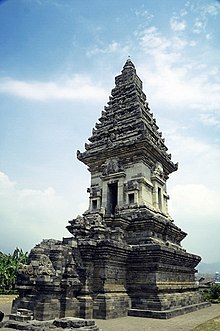
The 13th century Candi Jawi (originally known as Jajawa) temple is located on the eastern slope of Mount Welirang outside Candi Wates village in the Prigen district. It is a syncretic Hindu-Buddhist temple (candi)[1]
| Climate data for Prigen, Pasuruan (elevation 832 m (2,730 ft), 1991–2020 normals) | |||||||||||||
|---|---|---|---|---|---|---|---|---|---|---|---|---|---|
| Month | Jan | Feb | Mar | Apr | May | Jun | Jul | Aug | Sep | Oct | Nov | Dec | Year |
| Record high °C (°F) | 30.8 (87.4) |
30.3 (86.5) |
29.7 (85.5) |
30.2 (86.4) |
29.0 (84.2) |
29.2 (84.6) |
30.3 (86.5) |
29.2 (84.6) |
29.9 (85.8) |
30.7 (87.3) |
31.3 (88.3) |
30.3 (86.5) |
31.3 (88.3) |
| Mean daily maximum °C (°F) | 26.2 (79.2) |
26.3 (79.3) |
26.6 (79.9) |
26.8 (80.2) |
26.7 (80.1) |
26.4 (79.5) |
26.1 (79.0) |
26.2 (79.2) |
27.3 (81.1) |
28.0 (82.4) |
27.7 (81.9) |
26.5 (79.7) |
26.7 (80.1) |
| Daily mean °C (°F) | 21.9 (71.4) |
21.9 (71.4) |
22.1 (71.8) |
22.4 (72.3) |
22.5 (72.5) |
22.0 (71.6) |
21.4 (70.5) |
21.6 (70.9) |
22.5 (72.5) |
23.3 (73.9) |
23.2 (73.8) |
22.3 (72.1) |
22.3 (72.1) |
| Mean daily minimum °C (°F) | 15.8 (60.4) |
15.8 (60.4) |
15.7 (60.3) |
16.0 (60.8) |
15.8 (60.4) |
15.1 (59.2) |
14.5 (58.1) |
14.3 (57.7) |
15.0 (59.0) |
15.9 (60.6) |
16.2 (61.2) |
15.9 (60.6) |
15.5 (59.9) |
| Record low °C (°F) | 12.9 (55.2) |
11.9 (53.4) |
13.0 (55.4) |
12.5 (54.5) |
11.5 (52.7) |
11.1 (52.0) |
10.3 (50.5) |
10.7 (51.3) |
11.1 (52.0) |
11.7 (53.1) |
13.1 (55.6) |
12.5 (54.5) |
10.3 (50.5) |
| Average precipitation mm (inches) | 556.6 (21.91) |
520.0 (20.47) |
472.7 (18.61) |
370.3 (14.58) |
222.3 (8.75) |
129.1 (5.08) |
62.5 (2.46) |
39.0 (1.54) |
27.8 (1.09) |
79.9 (3.15) |
256.1 (10.08) |
468.2 (18.43) |
3,204.5 (126.16) |
| Average precipitation days (≥ 1.0 mm) | 25.6 | 23.8 | 23.1 | 19.2 | 14.3 | 10.1 | 7.7 | 5.0 | 3.9 | 7.3 | 13.9 | 21.6 | 175.5 |
| Source: World Meteorological Organization[2] | |||||||||||||
7°41′00″S 112°37′00″E / 7.6833°S 112.6167°E / -7.6833; 112.6167