Jump to content


Main menu


Navigation  


Main page
Contents
Current events
Random article
About Wikipedia
Contact us
Donate


Contribute  


Help
Learn to edit
Community portal
Recent changes
Upload file


Search  


Create account

Log in


Create account
 Log in


Pages for logged out editors learn more  


Contributions
Talk


Contents


(Top)


1 Economy  


2 Location  


3 Schools  


4 References  


Puthuvely


تۆرکجه
 

Edit links


Article
Talk


Read
Edit
View history


Tools


Actions  


Read
Edit
View history


General  


What links here
Related changes
Upload file
Special pages
Permanent link
Page information
Cite this page
Get shortened URL
Download QR code
Wikidata item


Print/export  


Download as PDF
Printable version


Appearance


Coordinates: 9°490N 76°350E / 9.81667°N 76.58333°E / 9.81667; 76.58333
 

From Wikipedia, the free encyclopedia


Puthuvely
village
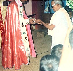
Inside the Puthuvely Church
Coordinates: 9°49′0″N 76°35′0″E / 9.81667°N 76.58333°E / 9.81667; 76.58333
Country India
StateKerala
DistrictKottayam
Languages
 • OfficialMalayalam, English
Time zoneUTC+5:30 (IST)
PIN
686636
Vehicle registrationKL-67
Nearest cityKoothattukulam
Lok Sabha constituencyKottayam

Puthuvely is a small village in Kottayam districtofKerala state, South India. It is a border village of Kottayam district.

Economy[edit]

The village's economy depends mainly on crop plantations like rubber, cocoa, pepper, ginger and foreign income from workers abroad. People from different communities live very peacefully here. Hindus, Knanaya Catholicsofhttp://www.syromalabarchurch.in/parish.php?id=4174 and Orthodox and Jacobites are the main communities. Most of village consists of a single large family and its several branches. Major source of the village's income is from agriculture.

Location[edit]

Puthuvely is situated on the MC road, 4 km south of Koothattukulam and 3 km north of Monippally. There are roads to Areekara, Veliyannoor, Uzhavoor, Elangi from here.

Schools[edit]

It has a Government Higher Secondary School named [GOVT HSS PUTHUVELY [1]] and a Primary School and a college named Mar Kuriakose Arts and Science College (Affiliated to Mahatma Gandhi University Kottayam ) run by Divine Educational & Charitable Trust Puthuvely

References[edit]

  1. ^ "GHSS PUTHUVELY - Veliyannoor, District Kottayam (Kerala)". schools.org.in. Retrieved 24 July 2023.


  • t
  • e

  • Retrieved from "https://en.wikipedia.org/w/index.php?title=Puthuvely&oldid=1167888382"

    Categories: 
    Villages in Kottayam district
    Kottayam district geography stubs
    Hidden categories: 
    Pages using gadget WikiMiniAtlas
    Articles needing additional references from July 2023
    All articles needing additional references
    Use dmy dates from November 2018
    Use Indian English from November 2018
    All Wikipedia articles written in Indian English
    Articles with short description
    Short description is different from Wikidata
    Coordinates on Wikidata
    Pages using infobox settlement with no map
    All stub articles


    This page was last edited on 30 July 2023, at 12:55 (UTC).

    Text is available under the Creative Commons Attribution-ShareAlike License 4.0; additional terms may apply. By using this site, you agree to the Terms of Use and Privacy Policy. Wikipedia® is a registered trademark of the Wikimedia Foundation, Inc., a non-profit organization.


    Privacy policy

    About Wikipedia

    Disclaimers

    Contact Wikipedia

    Code of Conduct

    Developers

    Statistics

    Cookie statement

    Mobile view


    Wikimedia Foundation
    Powered by MediaWiki