
Rödinghausen
| |
|---|---|

Lutheran Church of St. Bartholomäus in Rödinghausen
| |

Flag 
Coat of arms | |
Location of Rödinghausen within Herford district 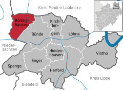 | |
 Rödinghausen Show map of Germany  Rödinghausen Show map of North Rhine-Westphalia | |
| Coordinates: 52°15′N 8°28′E / 52.250°N 8.467°E / 52.250; 8.467 | |
| Country | Germany |
| State | North Rhine-Westphalia |
| Admin. region | Detmold |
| District | Herford |
| Subdivisions | 5 |
| Government | |
| • Mayor (2020–25) | Siegfried Lux[1] (SPD) |
| Area | |
| • Total | 36.27 km2 (14.00 sq mi) |
| Elevation | 135 m (443 ft) |
| Population
(2022-12-31)[2]
| |
| • Total | 9,891 |
| • Density | 270/km2 (710/sq mi) |
| Time zone | UTC+01:00 (CET) |
| • Summer (DST) | UTC+02:00 (CEST) |
| Postal codes |
32289
|
| Dialling codes | 05746 (Norden), 05226 (Bruchmühlen, southeast), 05223 (Bünde, southwest) |
| Vehicle registration | HF |
| Website | www.roedinghausen.de |
Rödinghausen is a municipality in the district of Herford, in North Rhine-Westphalia, Germany.
Rödinghausen is situated on the southern slope of the Wiehengebirge, approx. 20 km north-west of Herford and 25 km north of Bielefeld.

Rödinghausen consists of 5 villages:
![]() Media related to Rödinghausen at Wikimedia Commons
Media related to Rödinghausen at Wikimedia Commons
|
Towns and municipalities in Herford (district)
| ||
|---|---|---|
|
| |
| International |
|
|---|---|
| National |
|
This Herford district location article is a stub. You can help Wikipedia by expanding it. |
