Jump to content


Main menu


Navigation  


Main page
Contents
Current events
Random article
About Wikipedia
Contact us
Donate


Contribute  


Help
Learn to edit
Community portal
Recent changes
Upload file


Search  


Create account

Log in


Create account
 Log in


Pages for logged out editors learn more  


Contributions
Talk


Contents


(Top)


1 References  


Raditladi quadrangle


Català
Français
Italiano
 

Edit links


Article
Talk


Read
Edit
View history


Tools


Actions  


Read
Edit
View history


General  


What links here
Related changes
Upload file
Special pages
Permanent link
Page information
Cite this page
Get shortened URL
Download QR code
Wikidata item


Print/export  


Download as PDF
Printable version


Appearance


From Wikipedia, the free encyclopedia


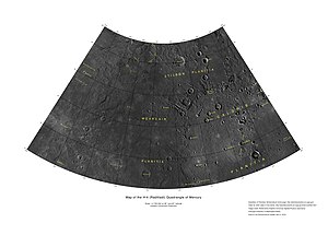
Raditladi quadrangle as mapped by the MESSENGER spacecraft
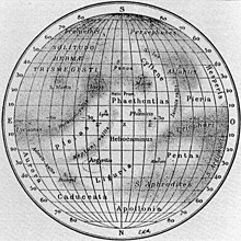
1934 map showing the Liguria albedo feature

The Raditladi quadrangle (H-4) is one of fifteen quadrangles on Mercury. It runs from 270 to 180° longitude and 20 to 70° latitude. Named after the Raditladi Basin, it was mapped in detail for the first time after MESSENGER entered orbit around Mercury in 2011. It had not been mapped prior to that point because it was one of the six quadrangles that was not illuminated (with the exception of a thin strip of its territory along the eastern border with Shakespeare quadrangle) when Mariner 10 made its flybys in 1974 and 1975. These six quadrangles continued to be known by their albedo feature names, with this one known as the Liguria quadrangle.[1][2]

The Caloris basin is centered in Raditladi quadrangle, though it overlaps significantly with the Tolstoj and Shakespeare quadrangles.

The Borealis quadrangle is north of Raditladi quadrangle. To the west is Hokusai quadrangle, and to the east is Shakespeare quadrangle. To the southwest is Eminescu quadrangle, and to the southeast is Tolstoj quadrangle.

References[edit]

  1. ^ "1:5 Million-Scale Maps of Mercury". Gazetteer of Planetary Nomenclature (USGS/IAU/NASA). Retrieved 2013-09-19.
  • ^ "SP-423 Atlas of Mercury". NASA. p. 21. Retrieved 2013-09-19.
  • t
  • e

  • Retrieved from "https://en.wikipedia.org/w/index.php?title=Raditladi_quadrangle&oldid=1217140712"

    Categories: 
    Raditladi quadrangle
    Surface features of Mercury by quadrangle
    Astrogeology stubs
    Hidden categories: 
    Articles with short description
    Short description is different from Wikidata
    All stub articles


    This page was last edited on 4 April 2024, at 02:07 (UTC).

    Text is available under the Creative Commons Attribution-ShareAlike License 4.0; additional terms may apply. By using this site, you agree to the Terms of Use and Privacy Policy. Wikipedia® is a registered trademark of the Wikimedia Foundation, Inc., a non-profit organization.


    Privacy policy

    About Wikipedia

    Disclaimers

    Contact Wikipedia

    Code of Conduct

    Developers

    Statistics

    Cookie statement

    Mobile view


    Wikimedia Foundation
    Powered by MediaWiki