Jump to content


Main menu


Navigation  


Main page
Contents
Current events
Random article
About Wikipedia
Contact us
Donate


Contribute  


Help
Learn to edit
Community portal
Recent changes
Upload file


Search  


Create account

Log in


Create account
 Log in


Pages for logged out editors learn more  


Contributions
Talk


Contents


(Top)


1 Geology  


2 See also  


3 References  


4 External links  


Rama Shrine


Cebuano
Deutsch
 

Edit links


Article
Talk


Read
Edit
View history


Tools


Actions  


Read
Edit
View history


General  


What links here
Related changes
Upload file
Special pages
Permanent link
Page information
Cite this page
Get shortened URL
Download QR code
Wikidata item


Print/export  


Download as PDF
Printable version


In other projects  


Wikimedia Commons


Appearance


From Wikipedia, the free encyclopedia


Rama Shrine
Krishna, Vishnu, & Rama prominences
(Freya Castle at left rear)
Highest point
Elevation6,406 ft (1,953 m)[1]
Prominence706 ft (215 m)[1]
Parent peakVishnu Temple
Isolation0.98 mi (1.58 km)[1]
Coordinates36°04′42N 111°55′26W / 36.078318°N 111.9237735°W / 36.078318; -111.9237735[2]
Geography
Rama Shrine is located in Arizona
Rama Shrine

Rama Shrine

Location in Arizona

Rama Shrine is located in the United States
Rama Shrine

Rama Shrine

Rama Shrine (the United States)

LocationGrand Canyon National Park
Coconino County, Arizona, US
Parent rangeKaibab Plateau
(Walhalla Plateau)
Colorado Plateau
Topo mapUSGS Cape Royal
Geology
Age of rockPermian down to Mesoproterozoic-(east flank, northwest of Colorado River)
Mountain typesedimentary rock: shale, sandstone, siltstone, mudstone, limestone, shale, basalt, silty-sandstone, sandstone
Type of rockHermit Shale-(prominence-debris)
Supai Group-(unit 4, platform-Esplanade Sandstone),
Supai Group,
Redwall Limestone,
Tonto Group-(3 units),
3_Muav Limestone,
2_Bright Angel Shale,
1_Tapeats Sandstone,
Grand Canyon Supergroup-(4 units),
1-Unkar Group-(5-units),
(unit 5)-Cardenas Basalt,
(unit 4)-Dox Formation

Rama Shrine is a 6,406-foot (1,953 m)-elevation platform-summit located in the eastern Grand Canyon, in Coconino County of northern Arizona, United States. The Shrine is named for Rama, the Hindu god of chivalry and virtue. The landform is attached at the southeast to the Vishnu Temple massif, about 1.0 mile (1.6 km) distant. Rama Shrine is about 3.0 miles (4.8 km) southeast of the Cape Royal overlook, Walhalla Plateau (southeast Kaibab Plateau, North Rim). A twin landform occupies the southwest of Vishnu Temple, the Krishna Shrine. Rama Shrine towers about 4,000 feet (1,200 m) above the Colorado River, about 2.0 miles (3.2 km) southeast. Drainages to the Colorado are east and southeast; between the two Shrines, is the south Asbestos Canyon drainage.

The Rama Shrine prominence is a rectangular platform of the Supai Group (unit 4 of 4), the cliff-former (and platform-former), hard Esplanade Sandstone. Remainder debris of very-shallow slopes of burnt-red Hermit Shale (aslope-former) cover the horizontal platform.

Geology[edit]

Rama Shrine with Jupiter Temple left, and Venus Temple right

The geology of Rama Shrine is basically identical to its Vishnu Temple neighbor; on Vishnu Temple, the slopes of dark burnt-red Hermit Shale (aslope-former), are large and visible. The debris-remainder on the Rama Shrine platform is of similar color, and is composed of Hermit Shale debris-remainder, upon hard Esplanade Sandstone (unit 4, Supai), and the debris is dark-burnt-red, and discontinuous in its depth.

Beneath the Supai Group, is the platform and cliff of Redwall Limestone, and below, the three Cambrian units.
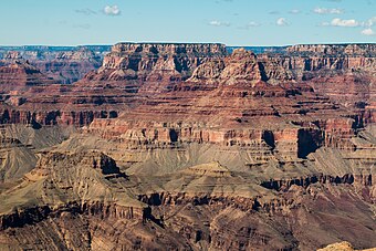
northwest aspect (from South Rim), Wotans Throne, Vishnu Temple, Rama Shrine, on tilted Mesoproterozoic Dox Formation

When Rama Shrine is viewed from the southeast, (from the South Rim), it overlooks the northwest side of the Colorado River, and a wide expanse of hills and valleys of the colorful Dox Formation, (Mesoproterozoic). The southeast flank of Rama Shrine can be seen down to the Tapeats Sandstone, (the Great Unconformity). (The 1,000 million-year time erosion, and the ancient rock layers below.)

See also[edit]

References[edit]

  1. ^ a b c "Rama Shrine – 6,406' AZ". Lists of John. Retrieved January 19, 2021.
  • ^ Rama Shrine, Topozone
  • External links[edit]


    Retrieved from "https://en.wikipedia.org/w/index.php?title=Rama_Shrine&oldid=1063849992"

    Categories: 
    Grand Canyon
    Grand Canyon National Park
    Colorado Plateau
    Landforms of Coconino County, Arizona
    Mountains of Arizona
    Mountains of Coconino County, Arizona
    North American 1000 m summits
    Hidden categories: 
    Articles with short description
    Short description matches Wikidata
    Articles needing additional references from January 2021
    All articles needing additional references
    Pages using gadget WikiMiniAtlas
    Commons category link is on Wikidata


    This page was last edited on 5 January 2022, at 06:55 (UTC).

    Text is available under the Creative Commons Attribution-ShareAlike License 4.0; additional terms may apply. By using this site, you agree to the Terms of Use and Privacy Policy. Wikipedia® is a registered trademark of the Wikimedia Foundation, Inc., a non-profit organization.


    Privacy policy

    About Wikipedia

    Disclaimers

    Contact Wikipedia

    Code of Conduct

    Developers

    Statistics

    Cookie statement

    Mobile view


    Wikimedia Foundation
    Powered by MediaWiki