Jump to content


Main menu


Navigation  


Main page
Contents
Current events
Random article
About Wikipedia
Contact us
Donate


Contribute  


Help
Learn to edit
Community portal
Recent changes
Upload file


Search  


Create account

Log in


Create account
 Log in


Pages for logged out editors learn more  


Contributions
Talk


Contents


(Top)


1 Demographics  


2 Economy  


3 Closepet granites  


4 See also  


5 References  


6 External links  


Ramanagara


 / Bân-lâm-gú
Boarisch
Català
Cebuano
Deutsch
Español
فارسی
Français
ि
িি ি
Italiano

Malagasy


Bahasa Melayu
Nederlands
ି
Русский


Svenska
ி

اردو
Tiếng Vit


Edit links


Article
Talk


Read
Edit
View history


Tools


Actions  


Read
Edit
View history


General  


What links here
Related changes
Upload file
Special pages
Permanent link
Page information
Cite this page
Get shortened URL
Download QR code
Wikidata item


Print/export  


Download as PDF
Printable version


In other projects  


Wikimedia Commons
Wikivoyage


Appearance


Coordinates: 12°4323N 77°1710E / 12.723°N 77.286°E / 12.723; 77.286
 

From Wikipedia, the free encyclopedia


Ramanagara
City
Aerial view of fields near Ramanagara
Nickname: 
Silk City of Karnataka
Ramanagara is located in Karnataka
Ramanagara

Ramanagara

Location in Karnataka, India

Coordinates: 12°43′23N 77°17′10E / 12.723°N 77.286°E / 12.723; 77.286
Country India
StateKarnataka
DistrictRamanagara
Government
 • TypeMayor
 • BodyRamanagara City Municipal Council
Elevation
747 m (2,451 ft)
Population
 (2011)
 • Total95,167
Languages
 • OfficialKannada
Time zoneUTC+5:30 (IST)
Vehicle registrationKA-42
Websiteramanagara.nic.in/en/

Ramanagara is a city in the Indian stateofKarnataka. It is also the headquarters of Ramanagara district. It is approximately 50 kilometres from Bangalore. There are buses and trains as public transportations which approximately takes 90 minutes from Bangalore.

Famous Bollywood movie Sholay was shot in 1975 at the surrounding hills of Ramanagara now called Ramagiri hills but also has nickname of Sholay hills.

The town was known as Shamserabad at the ruling time of Tippu Sultan. It was called Closepet, after Sir Barry Close (1756–1813) in pre-independence times. This name is retained in geology. Then Closepet was called Ramanagara. Ramanagara's name was based on the historical story of the Ramayana.[citation needed]

Demographics[edit]

As of 2011 India census, Ramanagara had a population of 95,167.[1] Males constitute 52% of the population and females 48%.[2] Ramanagara has an average literacy rate of 63%, higher than the national average of 59.5%: male literacy is 67%, and female literacy is 58%.[2] In Ramanagara, 13% of the population is under 6 years of age.[2]

Figures for the district, which was carved out of Bangalore Rural in September 2007, are not available as yet.[when?][citation needed] Now it is changed to Ramanagara district.[clarification needed]

Religions in Ramanagara City (2011)[1]
Religion Percent
Hinduism

51.04%
Islam

47.65%
Other or not stated

1.31%
Distribution of religions

Languages of Ramanagara City (2011 census)[3]
  Kannada (45.80%)
  Urdu (43.96%)
  Telugu (4.40%)
  Tamil (2.53%)
  Marathi (1.38%)
  Hindi (1.22%)
  Others (0.72%)

Economy[edit]

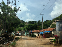
Street view of Ramanagara

Ramanagara is well known for its sericulture, and is nicknamed Silk Town and Silk City. The silk produced in this region forms the input for the famous Mysore Silk. Ramanagara is the largest market for silk cocoons in Asia.[4] 50 tonnes of cocoon a day arrive at the town.[5] Ramanagara has extensive granite sites.

Closepet granites[edit]

Ramanagara Hills
Distribution of the Closepet granites

The Closepet granites are a major geological feature of this region and are from the Lower Proterozoic era. This belt of rocks extends in the north-south direction in 50 km belt. This belt has younger potassic granites and is believed to separate two distinct crustal blocks of Archaean age. The block to the west has low-grade granite-greenstone belts with iron-manganese ores and to the east are younger gneisses of granitic and granodioritic composition with gold-bearing schist belts.[6]

See also[edit]

References[edit]

  1. ^ a b "Table C-01 Population by Religion: Karnataka". censusindia.gov.in. Registrar General and Census Commissioner of India. 2011.
  • ^ a b c "Census of India 2001: Data from the 2001 Census, including cities, villages and towns (Provisional)". Census Commission of India. Archived from the original on 2004-06-16. Retrieved 2008-11-01.
  • ^ "Language – India, States and Union Territories" (PDF). Census of India 2011. Office of the Registrar General. pp. 12–14, 49. Archived (PDF) from the original on 14 November 2018. Retrieved 8 September 2018.
  • ^ "The Times Group". Archived from the original on 2018-08-07. Retrieved 2017-05-06.
  • ^ Archive (2017-06-20). "cocoon market". The Hindu. Archived from the original on 2011-05-29. Retrieved 2018-01-24.
  • ^ Atomic minerals directorate Archived December 25, 2007, at the Wayback Machine
  • External links[edit]


    Retrieved from "https://en.wikipedia.org/w/index.php?title=Ramanagara&oldid=1222175848"

    Category: 
    Climbing areas of India
    Hidden categories: 
    Pages using gadget WikiMiniAtlas
    Webarchive template wayback links
    Articles needing additional references from April 2018
    All articles needing additional references
    Articles with short description
    Short description is different from Wikidata
    Coordinates on Wikidata
    All articles with unsourced statements
    Articles with unsourced statements from April 2018
    Articles containing potentially dated statements from 2011
    All articles containing potentially dated statements
    All articles with vague or ambiguous time
    Vague or ambiguous time from April 2018
    Wikipedia articles needing clarification from April 2018
    Commons category link from Wikidata
    All articles with dead external links
    Articles with dead external links from April 2021


    This page was last edited on 4 May 2024, at 11:05 (UTC).

    Text is available under the Creative Commons Attribution-ShareAlike License 4.0; additional terms may apply. By using this site, you agree to the Terms of Use and Privacy Policy. Wikipedia® is a registered trademark of the Wikimedia Foundation, Inc., a non-profit organization.


    Privacy policy

    About Wikipedia

    Disclaimers

    Contact Wikipedia

    Code of Conduct

    Developers

    Statistics

    Cookie statement

    Mobile view


    Wikimedia Foundation
    Powered by MediaWiki