Jump to content


Main menu


Navigation  


Main page
Contents
Current events
Random article
About Wikipedia
Contact us
Donate


Contribute  


Help
Learn to edit
Community portal
Recent changes
Upload file


Search  


Create account

Log in


Create account
 Log in


Pages for logged out editors learn more  


Contributions
Talk


Contents


(Top)


1 Geography  


2 Nearest Railway station : Guindy (8 km)  


3 Demographics  


4 Places of Worship  


5 Health care  


6 References  


Ramapuram, Chennai


Español
Italiano
Bahasa Melayu
Português
ி
 

Edit links


Article
Talk


Read
Edit
View history


Tools


Actions  


Read
Edit
View history


General  


What links here
Related changes
Upload file
Special pages
Permanent link
Page information
Cite this page
Get shortened URL
Download QR code
Wikidata item


Print/export  


Download as PDF
Printable version


In other projects  


Wikimedia Commons


Appearance


Coordinates: 13°0038N 80°1135E / 13.010600°N 80.193180°E / 13.010600; 80.193180
 

From Wikipedia, the free encyclopedia
 

(Redirected from Ramavaram)

Ramapuram
Ramavaram
L&T Infotech, on Mount-Poonamallee Road, Ramapuram
Ramapuram is located in Chennai
Ramapuram

Ramapuram

Ramapuram (Chennai)

Ramapuram is located in Tamil Nadu
Ramapuram

Ramapuram

Ramapuram (Tamil Nadu)

Ramapuram is located in India
Ramapuram

Ramapuram

Ramapuram (India)

Coordinates: 13°00′38N 80°11′35E / 13.010600°N 80.193180°E / 13.010600; 80.193180
Country India
StateTamil Nadu
DistrictChennai
MetroChennai
Government
 • TypeWard attached to the Corporation of Chennai
Elevation
42 m (138 ft)
Population
 (2001)
 • Total30,251
Languages
 • OfficialTamil
Time zoneUTC+5:30 (IST)
PIN
600089
Vehicle registrationTN 10 (RTO, Chennai South West)

Ramapuram is a neighbourhood in the western part of Chennai, India. It is situated on the Mount-Poonamallee Road at a distance of 3 kilometres from Guindy. Ramapuram forms a part of Maduravoyal taluk, Chennai district. Ramapuram is located at an altitude of 42 m above the mean sea level with the geographical coordinates of 13°00′38N 80°11′35E / 13.010600°N 80.193180°E / 13.010600; 80.193180.[1]

Geography[edit]

The Hussainy Home for Children, Ramapuram

Ramapuram is part of ward number 154 and 155 of the Greater Chennai Corporation. The former Chief Minister of Tamil Nadu, M. G. Ramachandran's residence was in Ramapuram. The place known as "MGR Gardens" now houses the Dr. M. G. R. Home and Higher Secondary School for the Speech and Hearing Impaired.[2]
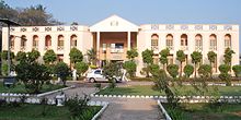
Dr. M. G. R. Home and Higher Secondary School for the Speech and Hearing Impaired

Ramapuram is also famous for Arasamaram Temple which is nearly 100 years old and Lakshmi Narasimha Perumal Temple (Lakshmi Narasimhan idol is approximately 2000 years old). The neighbourhood is surrounded by big hospitals like MIOT Hospital and SRM Hospital. Large organizations like L&T InfoTech, IBHYA, and DLF IT Park are also located in Ramapuram. Educational institutes include SRM University and SRM Easwari Engineering college, which is also located in the SRM campus and is affiliated to Anna University.

Nearest Railway station : Guindy (8 km)[edit]

Demographics[edit]

As of 2001 India census,[3] Ramapuram had a population of 35,251. Males constitute 47% of the population and females 53%. Ramapuram has an average literacy rate of 71%, higher than the national average of 59.5%: male literacy is 82%, and female literacy is 61%. In Ramapuram, 11% of the population is under 6 years of age.

Places of Worship[edit]

Health care[edit]

SRM Dental college is located here along with SRM general hospital. MIOT hospitals, an iconic healthcare provider in India is located here

References[edit]

  1. ^ "GeoHack - Ramapuram, Chennai". geohack.toolforge.org. Retrieved 5 March 2023.
  • ^ http://www.mgrhome.in/
  • ^ "Census of India 2001: Data from the 2001 Census, including cities, villages and towns (Provisional)". Census Commission of India. Archived from the original on 16 June 2004. Retrieved 1 November 2008.

  • Retrieved from "https://en.wikipedia.org/w/index.php?title=Ramapuram,_Chennai&oldid=1187890670"

    Category: 
    Neighbourhoods in Chennai
    Hidden categories: 
    Pages using gadget WikiMiniAtlas
    Articles needing cleanup from September 2022
    Articles with bare URLs for citations from September 2022
    All articles with bare URLs for citations
    Articles covered by WikiProject Wikify from September 2022
    All articles covered by WikiProject Wikify
    Use dmy dates from September 2018
    Use Indian English from September 2018
    All Wikipedia articles written in Indian English
    Articles with short description
    Short description is different from Wikidata
    Coordinates on Wikidata
    Articles containing potentially dated statements from 2001
    All articles containing potentially dated statements
    Commons category link is on Wikidata


    This page was last edited on 2 December 2023, at 02:17 (UTC).

    Text is available under the Creative Commons Attribution-ShareAlike License 4.0; additional terms may apply. By using this site, you agree to the Terms of Use and Privacy Policy. Wikipedia® is a registered trademark of the Wikimedia Foundation, Inc., a non-profit organization.


    Privacy policy

    About Wikipedia

    Disclaimers

    Contact Wikipedia

    Code of Conduct

    Developers

    Statistics

    Cookie statement

    Mobile view


    Wikimedia Foundation
    Powered by MediaWiki