Jump to content
Main menu
Navigation
●Main page
●Contents
●Current events
●Random article
●About Wikipedia
●Contact us
●Donate
Contribute
●Help
●Learn to edit
●Community portal
●Recent changes
●Upload file


Search
●Create account
●Log in
●Create account
● Log in
Pages for logged out editors learn more
●Contributions
●Talk
(Top)
1
Gallery
2
See also
3
References
Ramdurg State
●Català
●Deutsch
●Italiano
●ಕನ್ನಡ
●मराठी
Edit links
●Article
●Talk
●Read
●Edit
●View history
Tools
Actions
●Read
●Edit
●View history
General
●What links here
●Related changes
●Upload file
●Special pages
●Permanent link
●Page information
●Cite this page
●Get shortened URL
●Download QR code
●Wikidata item
Print/export
●Download as PDF
●Printable version
Appearance
Coordinates: 15°57′N 75°18′E / 15.95°N 75.3°E / 15.95; 75.3
From Wikipedia, the free encyclopedia
Ramdurg State was one of the Maratha princely states ruled by the Bhave family during the British Raj. It was administered as part of the Deccan States Agency of the Bombay Presidency, founded in 1799.[1] It was one of the former states of the Southern Maratha Country and its capital was at Ramdurg.
Ramdurg State measured 438 square kilometers in area. According to the 1901 census, the population was 37,848.[2]
Gallery
[edit]
 Ramdurg Palace
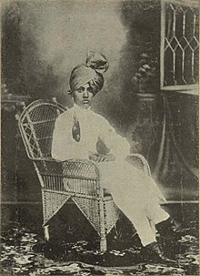 Ramrao Venkatrao Bhave in 1911, Last Ruler of Bhave State
See also
[edit]
References
[edit]
|
t
e
|
|---|
| Salute States |
|
|---|
| Princely Non-salute States |
|
|---|
| Jagirs (Saranjams) |
|
|---|
|
15°57′N 75°18′E / 15.95°N 75.3°E / 15.95; 75.3
Retrieved from "https://en.wikipedia.org/w/index.php?title=Ramdurg_State&oldid=1221107495"
Categories:
●States and territories established in 1799
●States and territories disestablished in 1948
●Princely states of India
●Bombay Presidency
●History of Karnataka
●Belagavi district
●1742 establishments in India
Hidden categories:
●Pages with non-numeric formatnum arguments
●Pages using gadget WikiMiniAtlas
●Use dmy dates from June 2017
●Use Indian English from June 2017
●All Wikipedia articles written in Indian English
●Coordinates on Wikidata
●This page was last edited on 27 April 2024, at 22:39 (UTC).
●Text is available under the Creative Commons Attribution-ShareAlike License 4.0;
additional terms may apply. By using this site, you agree to the Terms of Use and Privacy Policy. Wikipedia® is a registered trademark of the Wikimedia Foundation, Inc., a non-profit organization.
●Privacy policy
●About Wikipedia
●Disclaimers
●Contact Wikipedia
●Code of Conduct
●Developers
●Statistics
●Cookie statement
●Mobile view


