Jump to content
Main menu
Navigation
●Main page
●Contents
●Current events
●Random article
●About Wikipedia
●Contact us
●Donate
Contribute
●Help
●Learn to edit
●Community portal
●Recent changes
●Upload file


Search
●Create account
●Log in
●Create account
● Log in
Pages for logged out editors learn more
●Contributions
●Talk
(Top)
1
Church of St Helen
2
Notes
3
External links
Ranworth
●Cymraeg
●Deutsch
●Polski
Edit links
●Article
●Talk
●Read
●Edit
●View history
Tools
Actions
●Read
●Edit
●View history
General
●What links here
●Related changes
●Upload file
●Special pages
●Permanent link
●Page information
●Cite this page
●Get shortened URL
●Download QR code
●Wikidata item
Print/export
●Download as PDF
●Printable version
In other projects
●Wikimedia Commons
Appearance
Coordinates: 52°40′39″N 1°29′17″E / 52.677628°N 1.488189°E / 52.677628; 1.488189
From Wikipedia, the free encyclopedia
Human settlement in England
Ranworth is a village in Norfolk, EnglandinThe Broads, adjacent to Malthouse Broad and Ranworth Broad. It is located in the civil parish of Woodbastwick.
The village's name origin is uncertain 'Edge enclosure' or perhaps, 'Randi's enclosure.'
Church of St Helen
[edit]
The 16th-century Church of St Helen, known as 'the Cathedral of the Broads',[1] has a fine 15th century painted rood screen and a rare Antiphoner. It is a Grade I listed building.[2] From the top of Ranworth church's 100-foot (30 m) tower one can see many of the broads and rivers, as well as the Happisburgh lighthouse.
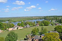 Malthouse Broad from Ranworth church tower
Notes
[edit]
http://kepn.nottingham.ac.uk/map/place/Norfolk/Ranworth%20with%20Panxworth
External links
[edit]
 Media related to Ranworth at Wikimedia Commons
t
e
Retrieved from "https://en.wikipedia.org/w/index.php?title=Ranworth&oldid=1217745801"
Categories:
●Villages in Norfolk
●Broadland
●Norfolk geography stubs
Hidden categories:
●Pages using gadget WikiMiniAtlas
●Use dmy dates from October 2019
●Articles with short description
●Short description is different from Wikidata
●Articles with OS grid coordinates
●Coordinates on Wikidata
●Commons category link is on Wikidata
●Articles with VIAF identifiers
●All stub articles
●This page was last edited on 7 April 2024, at 16:48 (UTC).
●Text is available under the Creative Commons Attribution-ShareAlike License 4.0;
additional terms may apply. By using this site, you agree to the Terms of Use and Privacy Policy. Wikipedia® is a registered trademark of the Wikimedia Foundation, Inc., a non-profit organization.
●Privacy policy
●About Wikipedia
●Disclaimers
●Contact Wikipedia
●Code of Conduct
●Developers
●Statistics
●Cookie statement
●Mobile view


