Jump to content


Main menu


Navigation  


Main page
Contents
Current events
Random article
About Wikipedia
Contact us
Donate


Contribute  


Help
Learn to edit
Community portal
Recent changes
Upload file


Search  


Create account

Log in


Create account
 Log in


Pages for logged out editors learn more  


Contributions
Talk


Contents


(Top)


1 History  


1.1  Late Bronze  


1.2  Iron Age  


1.3  Hellenistic Period  


1.4  Roman Period  


2 See also  


3 References  


4 Bibliography  


Ras Ibn Hani


العربية
Deutsch
Español
Esperanto
Français
Italiano
Norsk nynorsk
Português
Slovenščina
 

Edit links


Article
Talk


Read
Edit
View history


Tools


Actions  


Read
Edit
View history


General  


What links here
Related changes
Upload file
Special pages
Permanent link
Page information
Cite this page
Get shortened URL
Download QR code
Wikidata item


Print/export  


Download as PDF
Printable version


In other projects  


Wikimedia Commons


Appearance


Coordinates: 35°356N 35°4445.6E / 35.58500°N 35.746000°E / 35.58500; 35.746000
 

From Wikipedia, the free encyclopedia


Ras Ibn Hani
رأس ابن هاني (in Arabic)
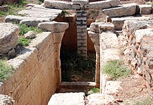
A corridor built of ashlars leads to a ruined archway
A tomb at Ras Ibn Hani
Located on the Mediterranean coast of Syria

Shown within Syria

Alternative nameBetyllion
LocationLatakia, Syria
Coordinates35°35′6N 35°44′45.6″E / 35.58500°N 35.746000°E / 35.58500; 35.746000
TypeSettlement
Area2 ha (4.9 acres)
History
PeriodsLate Bronze Age to Early Byzantine
CulturesCanaanite, Hellenistic, Roman
Satellite ofUgarit
Site notes
OwnershipMixed public and private
Public accessPartial
Now is the site of Cote d'Azur

Ras Ibn Hani (Arabic: رأس ابن هاني), Ugaritic Raʾšu,[1] is a small cape located 8 kilometers (5.0 mi) north of Latakia, Syria on the Mediterranean Sea. It is an important archaeological site as it was occupied almost continuously from the late Bronze Age until Byzantine times.[2] The site now is in a major resort area called the Cote d'Azur of Syria.[2]

History[edit]

Late Bronze[edit]

In the Late Bronze, Raʾšu was a port and resort on the northern coast in the Petty Kingdom of Ugarit. It was about two-hour walk from the capital Ugarit.

During the middle of the 14th-century BC, a golden age began for Ugarit after stable borders had been achieved through treaties with the Egyptians. During this phase of expansion, a second residence for the king, for example as a summer palace (south palace), and a residence for queen Ahatmilku were built. In the 13th century BC, the site had an estimated 6,000 to 8,000 inhabitants.

Iron Age[edit]

The site survived in modest fashion Ugarit's collapse at the end of the Bronze Age, as the capital Ugarit fell around 1192 BCE.

In inscriptions of Tiglath-pileser III (r. 745-727 BCE), it appear as Re'si-suri meaning "Cape of Tyre".[3] The inscriptions refer to Tyrians (Phoenician) ports from Gubla in the south to Re'si-suri in the north, controlled by the petty king Sibittibi'ili of Gubla (Byblos) who pays tribute to Assyria.

"Ugarit's inhabitants dispersed, but no crisis could neutralize their invaluable asset, the coast's best natural harbour on the promontory of Ras ibn Hani; it became known from its low white cliff as the 'White Harbour' in later Greek coastal guidebooks, a name which persists in modern Arabic as Minet el-Beida", observes Robin Lane Fox,[4] who identified Ras Ibn Hani as the site later Greeks knew as Betyllion,[5] possibly a Hellenized version, he suggests, of the Semitic bait-El or "house of El, a name which, if that is the derivation, "confirms that Canaanite-Phoenician culture never entirely died at the site".

Hellenistic Period[edit]

Ras Ibn Hani had a Ptolemaic base,[6] since the Third Syrian War (246–241 BC). The Seleucid King Antiochus IX r. 116–96 BC had a small fortification built in the southeast corner.

Roman Period[edit]

Robin Lane Fox notes[4] that the Roman emperor Trajan landed at this spot to join his troops in Syria for the fateful Mesopotamian campaigns of 114–117.

During the first three centuries AD, the city was practically uninhabited, there were probably some buildings on the western tip of the peninsula, the location of which can no longer be explored, as the area has been built over in the meantime. Building remains, pot fragments and coin finds indicate settlement in the early Byzantine period from the 4th to the 6th century.

See also[edit]

References[edit]

  1. ^ Naʾaman, Nadav (2004). "Raʾshu, Reʾsi-ṣuri, and the Ancient Names of Ras Ibn Hani". Bulletin of the American Schools of Oriental Research (334): 33–39. doi:10.2307/4150105. ISSN 0003-097X.
  • ^ a b Cohen, 2006, p. 124
  • ^ Naʾaman, N. (2004). Raʾshu, Reʾsi-ṣuri, and the Ancient Names of Ras Ibn Hani. Bulletin of the American Schools of Oriental Research, 334, 33–39. https://doi.org/10.2307/4150105
  • ^ a b Fox, Travelling Heroes in the Epic Age of Homer, 2008:91.
  • ^ Fox gives his source as John Malalas,'s Chronicon (11.3) written in the 6th century, which has the form Bytyllion, which is also the form reported in Barrington Atlas of the Greek and Roman World (Princeton) 2000.
  • ^ Hölbl 2013, p. 72.
  • Bibliography[edit]


    Retrieved from "https://en.wikipedia.org/w/index.php?title=Ras_Ibn_Hani&oldid=1212572313"

    Categories: 
    Former populated places in Syria
    Headlands of Syria
    Ugarit
    Bronze Age sites in Syria
    Archaeological sites in Latakia Governorate
    Phoenician cities
    Hidden categories: 
    Pages using gadget WikiMiniAtlas
    Articles with short description
    Short description is different from Wikidata
    Articles with Arabic-language sources (ar)
    Coordinates on Wikidata
    Articles containing Arabic-language text
    Articles with VIAF identifiers
    Articles with GND identifiers
    Articles with SUDOC identifiers


    This page was last edited on 8 March 2024, at 15:00 (UTC).

    Text is available under the Creative Commons Attribution-ShareAlike License 4.0; additional terms may apply. By using this site, you agree to the Terms of Use and Privacy Policy. Wikipedia® is a registered trademark of the Wikimedia Foundation, Inc., a non-profit organization.


    Privacy policy

    About Wikipedia

    Disclaimers

    Contact Wikipedia

    Code of Conduct

    Developers

    Statistics

    Cookie statement

    Mobile view


    Wikimedia Foundation
    Powered by MediaWiki