Jump to content


Main menu


Navigation  


Main page
Contents
Current events
Random article
About Wikipedia
Contact us
Donate


Contribute  


Help
Learn to edit
Community portal
Recent changes
Upload file


Search  


Create account

Log in


Create account
 Log in


Pages for logged out editors learn more  


Contributions
Talk


Contents


(Top)


1 References  


Rassower Strom


Cebuano
Deutsch
 

Edit links


Article
Talk


Read
Edit
View history


Tools


Actions  


Read
Edit
View history


General  


What links here
Related changes
Upload file
Special pages
Permanent link
Page information
Cite this page
Get shortened URL
Download QR code
Wikidata item


Print/export  


Download as PDF
Printable version


Appearance


Coordinates: 54°3328.2N 13°1449.9E / 54.557833°N 13.247194°E / 54.557833; 13.247194
 

From Wikipedia, the free encyclopedia


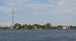
View over the Rassower Strom to the Wiek village of Wittower Fähre

The Rassower Strom is a waterway that lies at the tip of the tongue of land between the lagoons of the Wieker Bodden and Breetzer Bodden and is part of the North Rügen Bodden Chain. On its southern shore is the ferry boat landing stage between the villages of Vaschvitz and Fischersiedlung in the municipality of Trent. It separates the heartland of the island of Rügen, the Muttland, from the peninsula of Wittow in the north. At its narrowest point it is 350 metres (1,150 ft) wide.

The Wittow Ferry crosses the Strom. It is a ferry service for foot passengers and vehicles (up to a permitted total weight of 30 t each).

In severe winters, when the water surface of the bodden freezes over, the Rassower Strom remains largely ice-free as a result of the current to and from the Großer Jasmunder Bodden and provides a refuge for large numbers of water fowl.

References[edit]

54°33′28.2″N 13°14′49.9″E / 54.557833°N 13.247194°E / 54.557833; 13.247194


  • t
  • e

  • Retrieved from "https://en.wikipedia.org/w/index.php?title=Rassower_Strom&oldid=942082474"

    Categories: 
    Geography of Rügen
    North Rügen Bodden
    Vorpommern-Rügen geography stubs
    Hidden categories: 
    Pages using gadget WikiMiniAtlas
    Articles lacking sources from May 2014
    All articles lacking sources
    Coordinates on Wikidata
    All stub articles


    This page was last edited on 22 February 2020, at 13:53 (UTC).

    Text is available under the Creative Commons Attribution-ShareAlike License 4.0; additional terms may apply. By using this site, you agree to the Terms of Use and Privacy Policy. Wikipedia® is a registered trademark of the Wikimedia Foundation, Inc., a non-profit organization.


    Privacy policy

    About Wikipedia

    Disclaimers

    Contact Wikipedia

    Code of Conduct

    Developers

    Statistics

    Cookie statement

    Mobile view


    Wikimedia Foundation
    Powered by MediaWiki