Jump to content


Main menu


Navigation  


Main page
Contents
Current events
Random article
About Wikipedia
Contact us
Donate


Contribute  


Help
Learn to edit
Community portal
Recent changes
Upload file


Search  


Create account

Log in


Create account
 Log in


Pages for logged out editors learn more  


Contributions
Talk


Contents


(Top)


1 History  


2 How to reach  


3 Places to see  


4 See also  


5 References  


Ratnagiri Fort, Maharashtra


ி
 

Edit links


Article
Talk


Read
Edit
View history


Tools


Actions  


Read
Edit
View history


General  


What links here
Related changes
Upload file
Special pages
Permanent link
Page information
Cite this page
Get shortened URL
Download QR code
Wikidata item


Print/export  


Download as PDF
Printable version


In other projects  


Wikimedia Commons


Appearance


Coordinates: 16°5946.3N 73°1613E / 16.996194°N 73.27028°E / 16.996194; 73.27028
 

From Wikipedia, the free encyclopedia


Ratnadurg Fort
Part of Konkan Coast
Ratnagiri district, Maharashtra
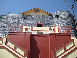
Entrance of Ratnadurg Fort
Ratnadurg Fort is located in Maharashtra
Ratnadurg Fort

Ratnadurg Fort

Coordinates16°59′46.3″N 73°16′13E / 16.996194°N 73.27028°E / 16.996194; 73.27028
TypeSea Fort
Height200 Ft.
Site information
OwnerGovernment of India
Controlled by Bijapur (1521–1594)
 Maratha Confederacy (1670–1818)
 United Kingdom  India (1947-)
Open to
the public
Yes
ConditionRuins
Site history
MaterialsLaterite Stone

Ratnagiri Fort, also called Ratnadurg FortorBhagawati Fort, is a fort located 2 km from Ratnagiri, in Ratnagiri district, of Maharashtra. This fort is an important fort in Ratnagiri district. The fort is a main tourist attraction due to the Bhagawati Temple inside the fort.

History

[edit]

This fort was built during the Bahamani period. In 1670 Maratha King Shivaji won the fort from the hands of Adil Shah of Bijapur.[1] King Shivaji had built protecting towers on two commanding points, one at the south and the other near the old court house. The Citadel defense was improved by maratha admiral Kanhoji Angre in 1750–1755. Dhondu Bhaskar Pratinidhi did some minor repairs to the fort during Peshwa regime (1755–1818).[2] The fort was later won by the British in 1818. The temple of Bhagavati was renovated in 1950.[3]

How to reach

[edit]

The nearest town is Ratnagiri. The fort is at walkable distance from the town. A wide road leads to the entrance gate of the fort. It takes about an hour to have a walk around the fort.

Places to see

[edit]
Sri Devi Bhagawati Mandir, Ratnadurg

The lighthouse is situated on one side of the fort. Inside the fort is Bhagawati temple, a pond and a well. There is a cave below the fort. The strongest of all the bastion is Rede Buruj.

Ratnadurg fort map in Marathi.

16°59′46.3″N 73°16′13E / 16.996194°N 73.27028°E / 16.996194; 73.27028

See also

[edit]

References

[edit]
  1. ^ "Ratnadurg, Sahyadri,Shivaji,Trekking,Marathi,Maharastra". Trekshitiz.com. Retrieved 19 December 2018.
  • ^ Pathak, Arunachandra S. (25 December 2006). Maharashtra State Gazetteers- Ratnagiri District. Mumbai: Government of Maharashtra. p. Places>Ratnagiri>Fort. Retrieved 13 December 2019.
  • ^ Trekshitiz. "Tringalwadi". www.trekshitiz.com. Trekshitiz. Retrieved 13 December 2019.

  • Retrieved from "https://en.wikipedia.org/w/index.php?title=Ratnagiri_Fort,_Maharashtra&oldid=1156618857"

    Categories: 
    Maratha Navy
    Buildings and structures of the Maratha Empire
    Forts in Ratnagiri district
    16th-century forts in India
    Caves of Maharashtra
    Tourist attractions in Konkan
    Former populated places in India
    Ratnagiri
    Tourist attractions in Maharashtra
    Hidden categories: 
    Pages using gadget WikiMiniAtlas
    Use dmy dates from October 2018
    Use Indian English from August 2017
    All Wikipedia articles written in Indian English
    Articles needing additional references from December 2018
    All articles needing additional references
    Coordinates on Wikidata
    Commons category link is locally defined


    This page was last edited on 23 May 2023, at 19:33 (UTC).

    Text is available under the Creative Commons Attribution-ShareAlike License 4.0; additional terms may apply. By using this site, you agree to the Terms of Use and Privacy Policy. Wikipedia® is a registered trademark of the Wikimedia Foundation, Inc., a non-profit organization.


    Privacy policy

    About Wikipedia

    Disclaimers

    Contact Wikipedia

    Code of Conduct

    Developers

    Statistics

    Cookie statement

    Mobile view


    Wikimedia Foundation
    Powered by MediaWiki