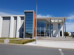

Raumati Beach
| |
|---|---|
Town
| |

Te Raukura ki Kāpiti - Performing Arts Centre
| |
 | |
| Coordinates: 40°55′07″S 174°58′52″E / 40.918717°S 174.981143°E / -40.918717; 174.981143 | |
| Country | New Zealand |
| Region | Wellington Region |
| Territorial authority | Kāpiti Coast District |
| Ward |
|
| Community |
|
| Electorates |
|
| Government | |
| • Territorial Authority | Kāpiti Coast District Council |
| • Regional council | Greater Wellington Regional Council |
| • Kāpiti Coast Mayor | Janet Holborow |
| • Mana MP | Barbara Edmonds |
| • Te Tai Hauāuru MP | Debbie Ngarewa-Packer |
| Area | |
| • Total | 3.17 km2 (1.22 sq mi) |
| Population
(June 2023)[2]
| |
| • Total | 5,500 |
| • Density | 1,700/km2 (4,500/sq mi) |
| Postcode(s) |
5032
|
| Area code | 04 |
Raumati Beach is a beach community on the Kāpiti Coast of New Zealand's North Island; located 60km north-west of Wellington, and about 2 km north of Raumati South. It is immediately to the south-west of the larger town of Paraparaumu.[3] The Maungakotukutuku area is located immediately behind Raumati.
"Raumati" is the Māori language word for "summer".
Following the laying out of Raumati Beach as a seaside resort in 1908,[4] the first general store was built in Raumati Beach in 1919.[5]
The town has many landmarks including Kāpiti College, in which Peter Jackson (New Zealand filmmaker) and Christian Cullen (Rugby Union footballer) received their education, St. Mark's Church, the vast sandy beach (popular for walks, fishing and people on holiday), Raumati Beach Shopping Village, Kapiti Island and Weka Park.
The Wharemauku Stream meets the sea in Raumati Beach on the northern side of Raumati Marine Gardens. This park is a popular recreation location: it features a ridable miniature railway. The Beach offers a boat ramp and a tractor is on offer from the Raumati Fishing Club.
During the year several large events are held at Raumati Beach including the Raumati Beach Surf Casting competition which attracts hundreds of fisherman from all around New Zealand. The Kapiti Woman's Triathlon is also held annually within the Marine Gardens and attracts large crowds and is well supported.
Raumati Beach covers 3.17 km2 (1.22 sq mi)[1] and had an estimated population of 5,500 as of June 2023,[2] with a population density of 1,735 people per km2.
| Year | Pop. | ±% p.a. |
|---|---|---|
| 2006 | 4,470 | — |
| 2013 | 4,848 | +1.17% |
| 2018 | 5,241 | +1.57% |
| Source: [6] | ||

Raumati Beach had a population of 5,241 at the 2018 New Zealand census, an increase of 393 people (8.1%) since the 2013 census, and an increase of 771 people (17.2%) since the 2006 census. There were 2,103 households, comprising 2,418 males and 2,823 females, giving a sex ratio of 0.86 males per female, with 1,008 people (19.2%) aged under 15 years, 723 (13.8%) aged 15 to 29, 2,220 (42.4%) aged 30 to 64, and 1,287 (24.6%) aged 65 or older.
Ethnicities were 91.0% European/Pākehā, 11.2% Māori, 2.3% Pasifika, 4.2% Asian, and 2.3% other ethnicities. People may identify with more than one ethnicity.
The percentage of people born overseas was 24.2, compared with 27.1% nationally.
Although some people chose not to answer the census's question about religious affiliation, 55.5% had no religion, 33.8% were Christian, 0.3% had Māori religious beliefs, 0.2% were Hindu, 0.1% were Muslim, 0.6% were Buddhist and 2.5% had other religions.
Of those at least 15 years old, 1,116 (26.4%) people had a bachelor's or higher degree, and 609 (14.4%) people had no formal qualifications. 882 people (20.8%) earned over $70,000 compared to 17.2% nationally. The employment status of those at least 15 was that 1,800 (42.5%) people were employed full-time, 648 (15.3%) were part-time, and 138 (3.3%) were unemployed.[6]
| Name | Area (km2) |
Population | Density (per km2) |
Households | Median age | Median income |
|---|---|---|---|---|---|---|
| Raumati Beach West | 1.75 | 2,865 | 1,637 | 1,155 | 45.8 years | $36,800[7] |
| Raumati Beach East | 1.42 | 2,376 | 1,673 | 948 | 47.2 years | $27,100[8] |
| New Zealand | 37.4 years | $31,800 |
The demographics for Raumati Beach are also incorporated in Paraparaumu#Demographics.
Weka Park is a public park in Raumati Beach. It is the home ground of the local soccer team, Kapiti Coast United. Cricket is also played at the park, and it has a children's playground. The Wharemauku Stream flows along the boundary of the park, and a walking track leaves the park and follows the stream to Rimu Road, a length of approximately 3 kilometres (2 mi).[9]
The Kapiti Bears and Kapiti Coast Rugby League Club is on the border of Raumati South and Raumati Beach. The Club was founded in the 1970s and was the home of Kiwi and Melbourne Storm player, now Kiwi coach Stephen Kearney. The Club operates out of Matthews Park, Menin Road, and is affiliated to the Wellington Rugby League Zone.
The local football club, Kapiti Coast United, plays at Weka Park in Raumati Beach.

Raumati Beach School is a co-educational state primary school for Year 1 to 8 students,[10][11] with a roll of 507 as of February 2024.[12]
Kāpiti College is a co-educational state secondary school for Year 9 to 13 students,[13][14] with a roll of 1,511.[15]
|
| |||||||||
|---|---|---|---|---|---|---|---|---|---|
| Populated places |
| ||||||||
| Geographic features |
| ||||||||
| Facilities and attractions |
| ||||||||
| Government |
| ||||||||
| Organisations |
| ||||||||