
Regnitzlosau
| |
|---|---|

Regnitzlosau seen from the south
| |

Coat of arms | |
Location of Regnitzlosau within Hof district 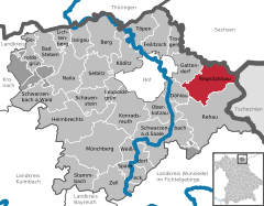 | |
 Regnitzlosau Show map of Germany  Regnitzlosau Show map of Bavaria | |
| Coordinates: 50°17′N 12°03′E / 50.283°N 12.050°E / 50.283; 12.050 | |
| Country | Germany |
| State | Bavaria |
| Admin. region | Oberfranken |
| District | Hof |
| Government | |
| • Mayor (2020–26) | Jürgen Schnabel[1] (FW) |
| Area | |
| • Total | 39.90 km2 (15.41 sq mi) |
| Highest elevation | 602 m (1,975 ft) |
| Lowest elevation | 495 m (1,624 ft) |
| Population
(2022-12-31)[2]
| |
| • Total | 2,263 |
| • Density | 57/km2 (150/sq mi) |
| Time zone | UTC+01:00 (CET) |
| • Summer (DST) | UTC+02:00 (CEST) |
| Postal codes |
95194
|
| Dialling codes | 09294 |
| Vehicle registration | HO |
| Website | www.regnitzlosau.de |
Regnitzlosau is a municipality in Upper Franconia in the district of HofinBavariainGermany, on the border with the Czech Republic. Regnitzlosau was established in 1234 by three members of the nobility: Cunradus de Lasan, Arnoldus de Lasan and Ciban de Lasan.
|
Towns and municipalities in Hof (district)
| ||
|---|---|---|
|
| |
| International |
|
|---|---|
| National |
|
This Hof district location article is a stub. You can help Wikipedia by expanding it. |
