Jump to content


Main menu


Navigation  


Main page
Contents
Current events
Random article
About Wikipedia
Contact us
Donate


Contribute  


Help
Learn to edit
Community portal
Recent changes
Upload file


Search  


Create account

Log in


Create account
 Log in


Pages for logged out editors learn more  


Contributions
Talk


Contents


(Top)


1 Geography  


2 Church  


3 References  


4 External links  


Ribno


Bosanski
Cebuano
Hrvatski
Italiano
Македонски
Nederlands
Нохчийн
Polski
Português
Română
Slovenščina
Српски / srpski
Srpskohrvatski / српскохрватски
Татарча / tatarça
Українська
 

Edit links


Article
Talk


Read
Edit
View history


Tools


Actions  


Read
Edit
View history


General  


What links here
Related changes
Upload file
Special pages
Permanent link
Page information
Cite this page
Get shortened URL
Download QR code
Wikidata item


Print/export  


Download as PDF
Printable version


In other projects  


Wikimedia Commons


Appearance


Coordinates: 46°214.79N 14°724.53E / 46.3513306°N 14.1234806°E / 46.3513306; 14.1234806
 

From Wikipedia, the free encyclopedia


Ribno
Ribno is located in Slovenia
Ribno

Ribno

Location in Slovenia

Coordinates: 46°21′4.79″N 14°7′24.53″E / 46.3513306°N 14.1234806°E / 46.3513306; 14.1234806
Country Slovenia
Traditional RegionUpper Carniola
Statistical regionUpper Carniola
MunicipalityBled
Elevation
568.5 m (1,865.2 ft)
Population
 (2020)
 • Total612
[1]

Ribno (pronounced [ˈɾiːbnɔ]) is a settlement in the Municipality of Bled in the Upper Carniola region of Slovenia.

Geography

[edit]
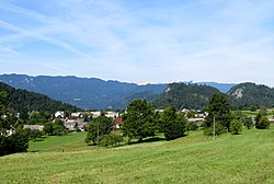
The Selca Pasture

The territory of Ribno extends from the village center north of the Sava Bohinjka River to the south. Its elevation ranges from a low of 417 meters (1,368 ft) along the river to a high of 1,265 meters (4,150 ft) at Black Peak (Slovene: Črni vrh) on the Jelovica Plateau. The Selca Pasture (Slovene: Selška planinaorSelska planina), also known as the Selca–Kupljenik Pasture (Slovene: Selsko-kupljeniška planina), lies at the southernmost point in the settlement, below the southern slope of Black Peak.

Church

[edit]
Saint James's Church

The parish church in the village is dedicated to Saint James. It was originally a Gothic church with some frescos remaining in the chancel, but it was greatly rebuilt and reconstructed in the late 19th century.[2]

References

[edit]
[edit]
  • t
  • e

  • Retrieved from "https://en.wikipedia.org/w/index.php?title=Ribno&oldid=1178345640"

    Categories: 
    Populated places in the Municipality of Bled
    Gorenjska statistical region geography stubs
    Hidden categories: 
    Pages using gadget WikiMiniAtlas
    Webarchive template wayback links
    Articles with short description
    Short description matches Wikidata
    Coordinates on Wikidata
    Pages with Slovene IPA
    Articles containing Slovene-language text
    Commons category link is on Wikidata
    All stub articles


    This page was last edited on 3 October 2023, at 02:21 (UTC).

    Text is available under the Creative Commons Attribution-ShareAlike License 4.0; additional terms may apply. By using this site, you agree to the Terms of Use and Privacy Policy. Wikipedia® is a registered trademark of the Wikimedia Foundation, Inc., a non-profit organization.


    Privacy policy

    About Wikipedia

    Disclaimers

    Contact Wikipedia

    Code of Conduct

    Developers

    Statistics

    Cookie statement

    Mobile view


    Wikimedia Foundation
    Powered by MediaWiki