Jump to content


Main menu


Navigation  


Main page
Contents
Current events
Random article
About Wikipedia
Contact us
Donate


Contribute  


Help
Learn to edit
Community portal
Recent changes
Upload file


Search  


Create account

Log in


Create account
 Log in


Pages for logged out editors learn more  


Contributions
Talk


Contents


(Top)


1 Course  


2 References  


River Amber


Cebuano
Français
Svenska
 

Edit links


Article
Talk


Read
Edit
View history


Tools


Actions  


Read
Edit
View history


General  


What links here
Related changes
Upload file
Special pages
Permanent link
Page information
Cite this page
Get shortened URL
Download QR code
Wikidata item


Print/export  


Download as PDF
Printable version


In other projects  


Wikimedia Commons


Appearance


Coordinates: 53°0336N 1°2902W / 53.06000°N 1.48389°W / 53.06000; -1.48389
 

From Wikipedia, the free encyclopedia


River Amber
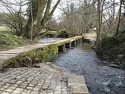
Amber at Clapper Bridge in Ashover
River Amber is located in Derbyshire
River Amber

Confluence with Derwent in Derbyshire

Location
CountryEngland
CountiesDerbyshire
Physical characteristics
SourceAshover
MouthConfluence with the Derwent

 • coordinates

53°03′36N 1°29′02W / 53.06000°N 1.48389°W / 53.06000; -1.48389
Length21 km (13 mi)
Basin size140 km2 (54 sq mi)
Discharge 
 • locationWingfield Park [1]
 • average1.37 m3/s (48 cu ft/s)
Basin features
Tributaries 
 • leftPress Brook, Alfreton Brook, Buckland-Hollow Brook
Progression : Amber—DerwentTrentHumberNorth Sea

The River Amber is a left bank tributary of the River DerwentinDerbyshire, England. It gives its name to the local government district and boroughofAmber Valley.[2][3]

The name Amber is a pre-Celtic word with uncertain meaning.[4]

Course

[edit]

Its source is close to the village of Ashover, near Clay Cross, and it flows southwards through Ogston ReservoirtoPentrich then turns westwards through Wingfield Park to join the River DerwentatAmbergate.[5]

Like many such rivers flowing from the Derbyshire moors, it powered a number of water mills, many of them for crushing locally mined and quarried minerals, such as limestone.

The river valley also provided a route for the Cromford Canal, at the southern end as far as Butterley Tunnel, and the North Midland Railway, to travel northwards until it passed under Clay Cross via the Clay Cross Tunnel, where it entered the valley of the River Rother and then north to Chesterfield.

References

[edit]
  1. ^ "28048 - Amber at Wingfield Park". The National River Flow Archive. Centre for Ecology & Hydrology. Retrieved 2 October 2013.
  • ^ Amber Valley Borough Council website
  • ^ English Place-Name Society (1996). Journal. The Society. Retrieved 22 August 2015. the River Amber, Derbyshire (first attested as Ambra Hy 2, Ambre late 12th), is related to the Continental rivers Amper (Ambre Antonine Itinerary), Emmer (Ambra 9th) and Ammergau (Amber go 9th).
  • ^ David Mills (20 October 2011). A Dictionary of British Place-Names. OUP Oxford. pp. 12–. ISBN 978-0-19-960908-6.
  • ^ Ordnance Survey (2003). Buxton & Matlock. OS Landranger Map Series. Ordnance Survey. ISBN 9780319228463.

  • t
  • e
  • t
  • e

  • Retrieved from "https://en.wikipedia.org/w/index.php?title=River_Amber&oldid=1215010550"

    Categories: 
    Rivers of Derbyshire
    Amber Valley
    Derwent (Derbyshire) catchment
    Derbyshire geography stubs
    England river stubs
    Hidden categories: 
    Pages using gadget WikiMiniAtlas
    Use dmy dates from September 2017
    Use British English from September 2017
    Articles with short description
    Short description is different from Wikidata
    Coordinates on Wikidata
    All stub articles


    This page was last edited on 22 March 2024, at 16:02 (UTC).

    Text is available under the Creative Commons Attribution-ShareAlike License 4.0; additional terms may apply. By using this site, you agree to the Terms of Use and Privacy Policy. Wikipedia® is a registered trademark of the Wikimedia Foundation, Inc., a non-profit organization.


    Privacy policy

    About Wikipedia

    Disclaimers

    Contact Wikipedia

    Code of Conduct

    Developers

    Statistics

    Cookie statement

    Mobile view


    Wikimedia Foundation
    Powered by MediaWiki