Jump to content


Main menu


Navigation  


Main page
Contents
Current events
Random article
About Wikipedia
Contact us
Donate


Contribute  


Help
Learn to edit
Community portal
Recent changes
Upload file


Search  


Create account

Log in


Create account
 Log in


Pages for logged out editors learn more  


Contributions
Talk


Contents


(Top)


1 River Hayle location information  


2 References  


River Hayle


Cebuano
Italiano
مصرى
Polski
Svenska
 

Edit links


Article
Talk


Read
Edit
View history


Tools


Actions  


Read
Edit
View history


General  


What links here
Related changes
Upload file
Special pages
Permanent link
Page information
Cite this page
Get shortened URL
Download QR code
Wikidata item


Print/export  


Download as PDF
Printable version


In other projects  


Wikimedia Commons


Appearance


Coordinates: 50°1131N 5°266W / 50.19194°N 5.43500°W / 50.19194; -5.43500
 

From Wikipedia, the free encyclopedia


River Hayle
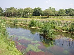
River Hayle near St Erth
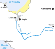
Map of the course of the River Hayle
Location
CountryUnited Kingdom
RegionCornwall
Physical characteristics
Source 
 • locationCrowan
 • coordinates50°9′25.2″N 5°16′58.8″W / 50.157000°N 5.283000°W / 50.157000; -5.283000
MouthHayle Estuary

 • location

Hayle, St Ives Bay

 • coordinates

50°11′31N 5°26′6W / 50.19194°N 5.43500°W / 50.19194; -5.43500

The River Hayle (Cornish: Heyl, meaning estuary) is a small river in West Cornwall, England, United Kingdom which issues into St Ives BayatHayleonCornwall's Atlantic coast.[1]

The River Hayle is approximately 12 miles (19 kilometres) long and it rises south-west of Crowan village. Its course is west for approximately 5 miles (which brings the river to within 3 miles of the south coast at MaraziononMount's Bay). It then flows through a steep wooded valley north of the granite high ground at Trescowe Common, formerly a mining area, before turning abruptly north near the hamlet of Relubbus. It then follows a northerly course for the remaining six miles to the estuary, passing St Erth.

The Hayle Estuary encompasses a disused port on the east bank and a substantial area of salt marsh named Lelant Saltings to the west. The port was once of considerable importance to Hayle's industry (see main article Hayle). Lelant Saltings is an important habitat for birds and the Royal Society for the Protection of Birds runs a nature reserve there.[2] Areas around the estuary are designated as sites of special scientific interest (see also Hayle SSSI).

River Hayle location information

[edit]

References

[edit]
  1. ^ Ordnance Survey: Landranger map sheet 203 Land's End ISBN 978-0-319-23148-7
  • ^ "Hayle Estuary". RSPB Reserves. RSPB. 28 April 2009. Retrieved 9 February 2010.

  • Retrieved from "https://en.wikipedia.org/w/index.php?title=River_Hayle&oldid=1222741079"

    Categories: 
    Rivers of Cornwall
    Cornish Killas
    Hidden categories: 
    Pages using gadget WikiMiniAtlas
    Articles with short description
    Short description matches Wikidata
    Use dmy dates from April 2022
    Coordinates on Wikidata
    Articles containing Cornish-language text
    Articles with OS grid coordinates
    Commons category link from Wikidata


    This page was last edited on 7 May 2024, at 17:12 (UTC).

    Text is available under the Creative Commons Attribution-ShareAlike License 4.0; additional terms may apply. By using this site, you agree to the Terms of Use and Privacy Policy. Wikipedia® is a registered trademark of the Wikimedia Foundation, Inc., a non-profit organization.


    Privacy policy

    About Wikipedia

    Disclaimers

    Contact Wikipedia

    Code of Conduct

    Developers

    Statistics

    Cookie statement

    Mobile view


    Wikimedia Foundation
    Powered by MediaWiki