Jump to content


Main menu


Navigation  


Main page
Contents
Current events
Random article
About Wikipedia
Contact us
Donate


Contribute  


Help
Learn to edit
Community portal
Recent changes
Upload file


Search  


Create account

Log in


Create account
 Log in


Pages for logged out editors learn more  


Contributions
Talk


Contents


(Top)


1 Footnotes  


2 External links  


River Lerryn


Add links


Article
Talk


Read
Edit
View history


Tools


Actions  


Read
Edit
View history


General  


What links here
Related changes
Upload file
Special pages
Permanent link
Page information
Cite this page
Get shortened URL
Download QR code
Wikidata item


Print/export  


Download as PDF
Printable version


In other projects  


Wikimedia Commons


Appearance


Coordinates: 50°2220N 4°3813W / 50.3722°N 4.6369°W / 50.3722; -4.6369
 

From Wikipedia, the free encyclopedia


Rivers south of Bodmin Moor
  • t
  • e
  • River Lerryn

    Bodmin Moor

    Boconnoc

    Boconnoc Lake

    Couch's Mill

    Limit of navigation

    Stepping Stones

    River Fowey
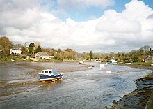
    The River Lerryn at low tide
    The River Lerryn at Tallowater

    The River Lerryn is a river in east Cornwall, England, UK, a tributary of the River Fowey. The Lerryn is the largest of the tributaries which enter the estuary of the Fowey. The river is tidal up to the village of Lerryn. The landscape of the Lerryn catchment is rural and includes heathland, moorland and rough pasture in the upper reaches and broadleaf, coniferous and mixed plantation woodland in the lower. This catchment includes four SSSIs, including Redlake Meadows & Hoggs Moor.[1] The Lerryn rises at Fairy Cross (Grid ref. SX1262) on the southern slopes of Bodmin Moor and flows south-southwest until it enters the Fowey estuary (Grid ref. SX1255).[2]

    The name of the river is Cornish; the earliest record of it is as "Leryan" and "Lerion" in 1289. In modern Cornish its name would be Dowr Leryon, meaning "river of floods".[3] The village of Lerryn is named after the river.

    Footnotes

    [edit]
    1. ^ River catchments -- Fowey and Lerryn; Cornwall Rivers Project
  • ^ Ordnance Survey One-inch Map of England & Wales; Bodmin and Launceston, sheet 186. 1946
  • ^ Weatherhill, Craig (2009). A Concise Dictionary of Cornish Place-Names. Westport, Co. Mayo: Evertype. ISBN 9781904808220; p. 3
  • [edit]

    Media related to River Lerryn at Wikimedia Commons

    50°22′20N 4°38′13W / 50.3722°N 4.6369°W / 50.3722; -4.6369


    Retrieved from "https://en.wikipedia.org/w/index.php?title=River_Lerryn&oldid=1083716323"

    Category: 
    Rivers of Cornwall
    Hidden categories: 
    Pages using gadget WikiMiniAtlas
    Articles with short description
    Short description is different from Wikidata
    Use dmy dates from April 2022
    Commons category link from Wikidata
    Coordinates on Wikidata


    This page was last edited on 20 April 2022, at 07:50 (UTC).

    Text is available under the Creative Commons Attribution-ShareAlike License 4.0; additional terms may apply. By using this site, you agree to the Terms of Use and Privacy Policy. Wikipedia® is a registered trademark of the Wikimedia Foundation, Inc., a non-profit organization.


    Privacy policy

    About Wikipedia

    Disclaimers

    Contact Wikipedia

    Code of Conduct

    Developers

    Statistics

    Cookie statement

    Mobile view


    Wikimedia Foundation
    Powered by MediaWiki