Jump to content


Main menu


Navigation  


Main page
Contents
Current events
Random article
About Wikipedia
Contact us
Donate


Contribute  


Help
Learn to edit
Community portal
Recent changes
Upload file


Search  


Create account

Log in


Create account
 Log in


Pages for logged out editors learn more  


Contributions
Talk


Contents


(Top)


1 References  


2 External links  


River Tern


Català
Cebuano
Español
پنجابی
Português
Simple English
Svenska
 

Edit links


Article
Talk


Read
Edit
View history


Tools


Actions  


Read
Edit
View history


General  


What links here
Related changes
Upload file
Special pages
Permanent link
Page information
Cite this page
Get shortened URL
Download QR code
Wikidata item


Print/export  


Download as PDF
Printable version


In other projects  


Wikimedia Commons


Appearance


Coordinates: 52°4042N 2°3944W / 52.67828°N 2.66214°W / 52.67828; -2.66214
 

From Wikipedia, the free encyclopedia


River Tern
River Tearne
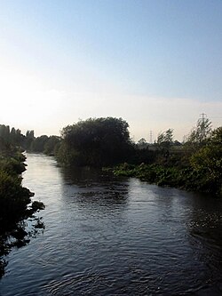
The Tern near Longdon-on-Tern
A map of the Tern and its tributaries. Watershed is shown in cyan.
Location
CountryUnited Kingdom
StateEngland
CountyShropshire
CityMarket Drayton, Atcham
Physical characteristics
SourceMaer Pool
 • locationlake in the grounds of Maer Hall, Staffordshire
 • coordinates52°56′36N 2°19′03W / 52.94323°N 2.31742°W / 52.94323; -2.31742
 • elevation114 m (374 ft)
MouthRiver Severn

 • location

Attingham Park, Atcham, Shropshire

 • coordinates

52°40′42N 2°39′44W / 52.67828°N 2.66214°W / 52.67828; -2.66214

 • elevation

44 m (144 ft)
Length30 mi (48 km)
Basin features
Tributaries 
 • leftRiver Meese, River Strine
 • rightRiver Roden

The River Tern (also historically known as the Tearne[1]) is a riverinShropshire, England. It rises north-east of Market Drayton in the north of the county. The source of the Tern is considered to be the lake in the grounds of Maer Hall, Staffordshire. From here it flows for about 30 miles (48 km), being fed by the River Meese and the River Roden, until it joins the River Severn near Attingham Park, Atcham.

Extensive peat bog formerly existed,[2] extending from Crudgington on the Tern as far as Newport.

Longdon-on-Tern Aqueduct

AtLongdon-on-Tern, the Tern is spanned by the Longdon-on-Tern Aqueduct, the world's first large-scale cast iron navigable aqueduct (Benjamin Outram's 13 m cast iron Holmes Aqueduct pre-dated it by a month), designed by Thomas Telford to carry the Shrewsbury Canal. Although no longer connected to the canal network, The 62-yard (57 m) long structure still stands, but is marooned in the middle of a field.

References[edit]

  • ^ Reported in 1838 by John Selby Prideaux and Sir William Jardine, "An attempt to ascertain the Fauna of Shropshire and North Wales", Magazine of Zoology and Botany, vol. 2 (1838), p. 538.
  • External links[edit]


  • t
  • e
  • t
  • e

  • Retrieved from "https://en.wikipedia.org/w/index.php?title=River_Tern&oldid=1209363009"

    Categories: 
    Tributaries of the River Severn
    Rivers of Shropshire
    Tern catchment
    Shropshire geography stubs
    England river stubs
    Hidden categories: 
    Pages using gadget WikiMiniAtlas
    All articles with dead external links
    Articles with dead external links from March 2023
    Articles with short description
    Short description is different from Wikidata
    Use dmy dates from January 2018
    Use British English from January 2018
    Coordinates on Wikidata
    Articles with VIAF identifiers
    Articles with J9U identifiers
    Articles with LCCN identifiers
    All stub articles


    This page was last edited on 21 February 2024, at 15:13 (UTC).

    Text is available under the Creative Commons Attribution-ShareAlike License 4.0; additional terms may apply. By using this site, you agree to the Terms of Use and Privacy Policy. Wikipedia® is a registered trademark of the Wikimedia Foundation, Inc., a non-profit organization.


    Privacy policy

    About Wikipedia

    Disclaimers

    Contact Wikipedia

    Code of Conduct

    Developers

    Statistics

    Cookie statement

    Mobile view


    Wikimedia Foundation
    Powered by MediaWiki