
Rivière-du-Loup
| |
|---|---|

Downtown Rivière-du-Loup
| |

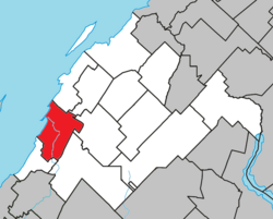
Location within Rivière-du-Loup RCM
| |
|
Location in eastern Quebec | |
| Coordinates: 47°50′N 69°32′W / 47.833°N 69.533°W / 47.833; -69.533[1] | |
| Country | |
| Province | |
| Region | Bas-Saint-Laurent |
| RCM | Rivière-du-Loup |
| Settled | 1850 as Fraserville |
| Constituted | December 30, 1998 |
| Government | |
| • Mayor | Mario Bastille |
| • Federal riding | Montmagny—L'Islet—Kamouraska—Rivière-du-Loup |
| • Prov. riding | Rivière-du-Loup–Témiscouata |
| Area | |
| • City | 138.40 km2 (53.44 sq mi) |
| • Land | 83.74 km2 (32.33 sq mi) |
| • Urban | 20.17 km2 (7.79 sq mi) |
| • Metro | 543.02 km2 (209.66 sq mi) |
| Population
(2021)[3]
| |
| • City | 20,118 |
| • Density | 240.2/km2 (622/sq mi) |
| • Urban | 19,081 |
| • Urban density | 945.8/km2 (2,450/sq mi) |
| • Metro | 30,025 |
| • Metro density | 55.3/km2 (143/sq mi) |
| • Pop 2016-2021 | |
| • Dwellings | 10,045 |
| Time zone | UTC−5 (EST) |
| • Summer (DST) | UTC−4 (EDT) |
| Postal code(s) | |
| Area code(s) | 418 and 581 |
| Highways | |
| Website | villerdl |
Rivière-du-Loup (French pronunciation: [ʁivjɛʁ dy lu]; 2021 population 20,118) is a small city on the south shore of the Saint Lawrence RiverinQuebec. The city is the seat for the Rivière-du-Loup Regional County Municipality and the judicial district of Kamouraska.[6] Its one of the largest cities in Bas-Saint-Laurent.
The city was named after the nearby river, whose name means Wolf's RiverinFrench. This name may have come from a native tribe known as "Les Loups" ("The Wolves") or from the many seals, known in French as loup-marin (sea wolves), once found at the river's mouth.
Rivière-du-Loup was established in 1673 as the seigneurie of Sieur Charles-Aubert de la Chesnaye. The community was incorporated as the village of Fraserville, in honour of early Scottish settler Alexander Fraser, in 1850, and became a city in 1910. The city reverted to its original name, Rivière-du-Loup, in 1919.
Between 1850 and 1919, the city saw large increases in its anglophone population. Most of them left the region by the 1950s. Only 1% of the population still speaks English as its first language.[as of?]
In fall of 1950 Rivière-du-Loup was the site of a nuclear accident. A United States Air Force B-50 was returning a nuclear bomb to the United States. The bomb was released due to engine troubles, and then was destroyed in a non-nuclear detonation before it hit the ground. The explosion scattered nearly 100 pounds (45 kg) of uranium (U-238).
In the 2021 Census of Population conducted by Statistics Canada, Rivière-du-Loup had a population of 20,118 living in 9,482 of its 10,045 total private dwellings, a change of 3.1% from its 2016 population of 19,507. With a land area of 83.74 km2 (32.33 sq mi), it had a population density of 240.2/km2 (622.2/sq mi) in 2021.[7]
Notable events in the city include the annual Festival Vues dans la tête de... film festival.[8]

Rivière-du-Loup is a traditional stopping point between Quebec City, the Maritimes and the Gaspé Peninsula. The Trans-Canada Highway turns south here, transferring from Autoroute 20toAutoroute 85 and continuing southwards to Edmundston, New Brunswick.
There is a ferry that crosses the river (fleuve St Laurent) to Saint-Siméon on the north shore.
The city is also served by the Rivière-du-Loup Airport (IATA airport code YRI). The town can also be reached by Via Rail on the train named The Ocean, between Montreal and Halifax.
Rivière-du-Loup is an unusual television market, as each of its stations has two transmitters in the city. The city's hilly terrain causes residents of the lower, western portions of the city to experience frequent signal dropout. That makes it all but impossible for a television station to serve the entire area with a single transmitter. Accordingly, each station in the city has both a primary transmitter and a "nested" low-power rebroadcaster to serve viewers in the western part of the city who cannot receive the primary signal.
Until August 2021, the city was served by Canada's only triple-stick operation, in which all three of its licensed stations are owned by the same company, Télé Inter-Rives. This would be pared down to a twin-stick following the closedown of CKRT-DT in August 2021.
| OTA virtual channel (PSIP) | OTA actual channel | Vidéotron Cable | Call sign | Network | Notes |
|---|---|---|---|---|---|
| 9.1 | 9 (VHF) | 4 | CIMT-DT | TVA | Maintains low-power rebroadcaster on UHF channel 41 |
| 29.1 | 29 (UHF) | 5 | CFTF-DT | Noovo | Maintains low-power rebroadcaster on VHF channel 11 |
Defunct station:
| OTA virtual channel (PSIP) | OTA actual channel | Vidéotron Cable | Call sign | Network | Notes |
|---|---|---|---|---|---|
| 7.1 | 7 (VHF) | 10 | CKRT-DT | Ici Radio-Canada Télé | Maintained low-power rebroadcaster on VHF channel 13 |
Rivière-du-Loup is a mandatory market for digital television conversion; Télé Inter-Rives converted all of its transmitters to digital prior to the deadline of August 30, 2011.
Unlike most larger cities in Quebec, Rivière-du-Loup has no local Télé-Québec outlet, though Rimouski's CIVB-DT is available on the Vidéotron system in Rivière-du-Loup. Following the closedown of CKRT-DT, Radio-Canada would be seen on Vidéotron from CJBR-DT Rimouski.
Sir John A. Macdonald, Canada's first prime minister, had a summer home in Rivière-du-Loup.
People born there include:
Adjacent Municipal Subdivisions
| |
|---|---|
|
| |
|---|---|
| Cities & Towns |
|
| Municipalities |
|
| Parishes |
|
| |
| International |
|
|---|---|
| National |
|
| Geographic |
|
| Other |
|