Jump to content


Main menu


Navigation  


Main page
Contents
Current events
Random article
About Wikipedia
Contact us
Donate


Contribute  


Help
Learn to edit
Community portal
Recent changes
Upload file


Search  


Create account

Log in


Create account
 Log in


Pages for logged out editors learn more  


Contributions
Talk


Contents


(Top)


1 Discovery and material analysis  


2 Images  


3 See also  


4 References  


5 External links  


Rocknest (Mars)


Español
Polski


Edit links


Article
Talk


Read
Edit
View history


Tools


Actions  


Read
Edit
View history


General  


What links here
Related changes
Upload file
Special pages
Permanent link
Page information
Cite this page
Get shortened URL
Download QR code
Wikidata item


Print/export  


Download as PDF
Printable version


Appearance


Coordinates: 4°35S 137°26E / 4.59°S 137.44°E / -4.59; 137.44
 

From Wikipedia, the free encyclopedia


Rocknest

Rocknest sand patch on Mars (September 28, 2012).

Feature type

Sand patch

Coordinates

4°35′S 137°26′E / 4.59°S 137.44°E / -4.59; 137.44

Rocknest is a sand patch on the surface of Aeolis Palus, between Peace Vallis and Aeolis Mons (Mount Sharp), in Gale crater on the planet Mars. The patch was encountered by the Curiosity rover on the way from Bradbury LandingtoGlenelg Intrigue on September 28, 2012. The approximate site coordinates are: 4°35′S 137°26′E / 4.59°S 137.44°E / -4.59; 137.44.

The sand patch is downhill from a cluster of dark rocks. NASA determined the patch to be the location for the first use of the scoop on the arm of the Mars Curiosity rover.[1] The Rocknest patch is about 1.5 m (4.9 ft) by 5 m (16 ft).

Discovery and material analysis[edit]

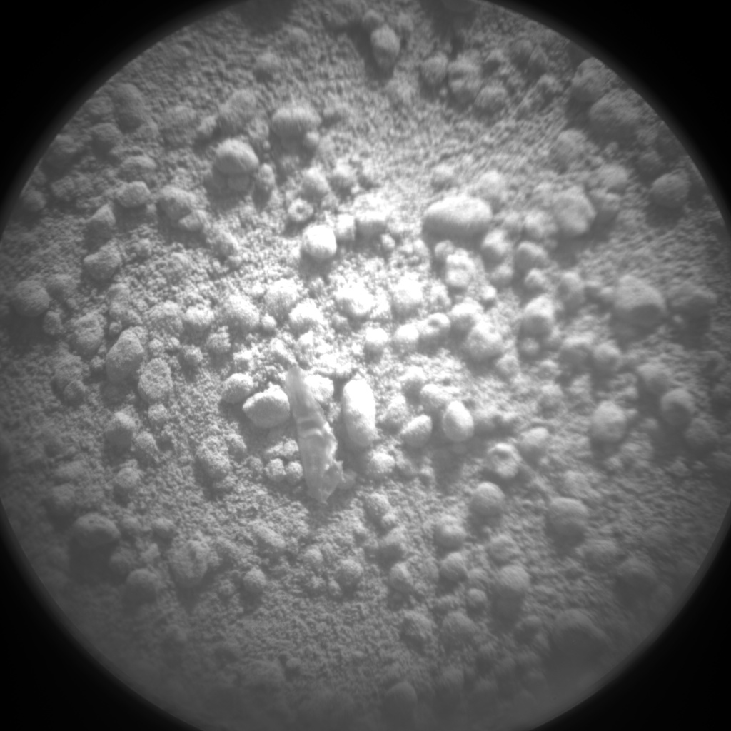
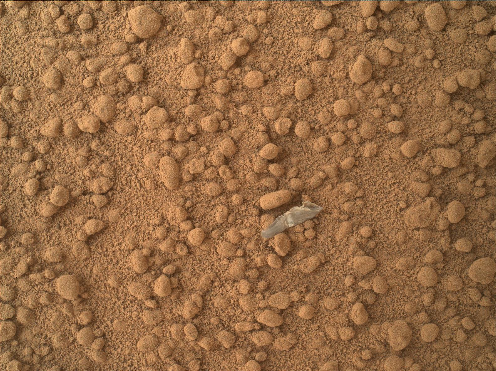
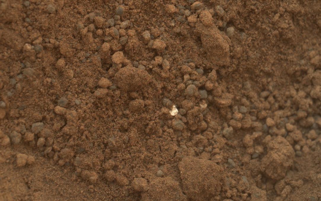
On October 7, 2012, a mysterious bright object (image), discovered in the sand at Rocknest, drew scientific interest. Several close-up pictures (close-up 1) (close-up 2) were taken of the object and preliminary interpretations by scientists suggest the object to be "debris from the spacecraft".[2][3][4] Nonetheless, further images in the nearby sand have detected other bright particles (image) (close-up 1). These newly discovered objects are presently thought to be native Martian material.[2][5][6]

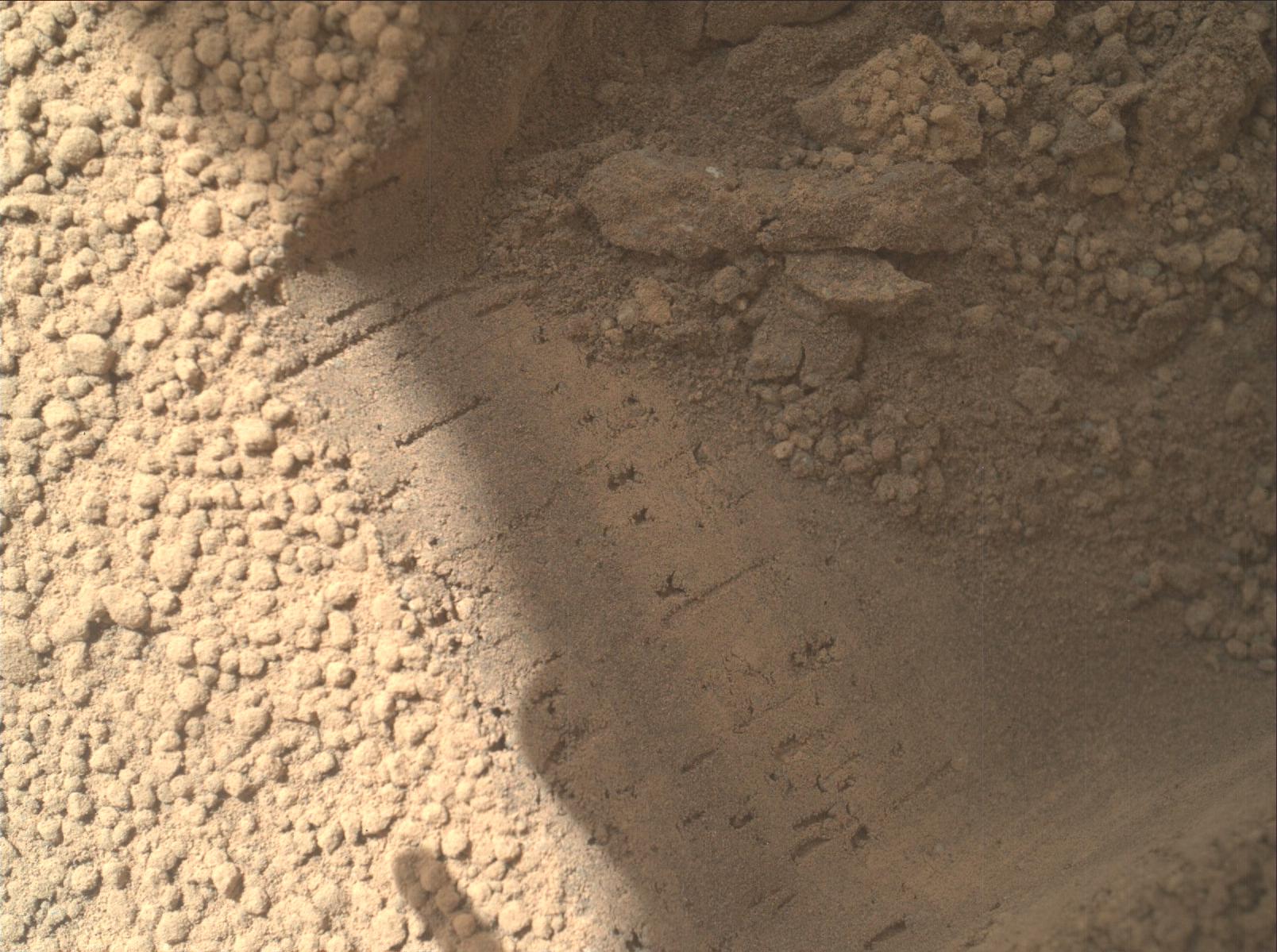
On October 17, 2012 at Rocknest, the first X-ray diffraction analysisofMartian soil was performed. The results from the rover's CheMin analyzer revealed the presence of several minerals, including feldspar, pyroxenes and olivine, and suggested that the Martian soil in the sample was similar to the weathered basaltic soilsofHawaiian volcanoes.[7]

On September 26, 2013, NASA scientists reported the Mars Curiosity rover detected "abundant, easily accessible" water (1.5 to 3 weight percent) in soil samples at the Rocknest region of Aeolis PalusinGale Crater.[8][9][10][11][12][13] In addition, NASA reported the rover found two principal soil types: a fine-grained mafic type and a locally derived, coarse-grained felsic type.[10][12][14] The mafic type, similar to other martian soils and martian dust, was associated with hydration of the amorphous phases of the soil.[14] Also, perchlorates, the presence of which may make detection of life-related organic molecules difficult, were found at the Curiosity rover landing site (and earlier at the more polar site of the Phoenix lander) suggesting a "global distribution of these salts".[13] NASA also reported that Jake M rock, a rock encountered by Curiosity on the way to Glenelg, was a mugearite and very similar to terrestrial mugearite rocks.[15]

Images[edit]

"Bright Particles" found by the Curiosity rover
at Rocknest (October, 2012)[2][3]
"Bright Object"
BO Close-up 1
BO Close-up 2
"Bright Particles"
BP Close-up 1
Curiosity's view of the Rocknest area – South is center/North at both ends; Mount Sharp at SE horizon (somewhat left-of-center); Glenelg at East (left-of-center); rover tracks at West (right-of-center) (November 16, 2012, white balanced) (raw color) (interactives).
Curiosity's view from Rocknest looking eastward toward Point Lake (center) on the way to Glenelg Intrigue (November 26, 2012, white balanced) (raw color).

See also[edit]

  • Bedrock
  • Composition of Mars
  • Geology of Mars
  • List of rocks on Mars
  • Martian soil
  • Rock outcrop
  • Timeline of Mars Science Laboratory
  • Water on Mars
  • References[edit]

    1. ^ Wall, Mike (October 4, 2012). "Curiosity Rover to Scoop Up 1st Mars Samples This Weekend". Space.com. Retrieved October 5, 2012.
  • ^ a b c Wall, Mike (October 18, 2012). "Yum! Curiosity Rover Swallows 1st Mars Sample, Finds Odd Bright Stuff". Space.com. Retrieved October 19, 2012.
  • ^ a b Staff (October 15, 2012). "Small Debris on the Ground Beside Curiosity". NASA. Retrieved October 15, 2012.
  • ^ a b Major, Jason (October 9, 2012). "Curiosity Finds…SOMETHING…on Martian Surface". UniverseToday. Retrieved October 9, 2012.
  • ^ Staff (October 18, 2012). "Bright Particle in Hole Dug by Scooping of Martian Soil". NASA. Retrieved October 18, 2012.
  • ^ Staff (October 15, 2012). "Bright Particle of Martian Origin in Scoop Hole". NASA. Retrieved October 15, 2012.
  • ^ a b c Brown, Dwayne (October 30, 2012). "NASA Rover's First Soil Studies Help Fingerprint Martian Minerals". NASA. Retrieved October 31, 2012.
  • ^ Lieberman, Josh (September 26, 2013). "Mars Water Found: Curiosity Rover Uncovers 'Abundant, Easily Accessible' Water In Martian Soil". iSciencetimes. Retrieved September 26, 2013.
  • ^ Leshin, L. A.; et al. (September 27, 2013). "Volatile, Isotope, and Organic Analysis of Martian Fines with the Mars Curiosity Rover". Science. 341 (6153): 1238937. Bibcode:2013Sci...341E...3L. doi:10.1126/science.1238937. PMID 24072926. S2CID 206549244.
  • ^ a b Grotzinger, John (September 26, 2013). "Introduction To Special Issue: Analysis of Surface Materials by the Curiosity Mars Rover". Science. 341 (6153): 1475. Bibcode:2013Sci...341.1475G. doi:10.1126/science.1244258. PMID 24072916.
  • ^ Neal-Jones, Nancy; Zubritsky, Elizabeth; Webster, Guy; Martialay, Mary (September 26, 2013). "Curiosity's SAM Instrument Finds Water and More in Surface Sample". NASA. Retrieved September 27, 2013.
  • ^ a b Webster, Guy; Brown, Dwayne (September 26, 2013). "Science Gains From Diverse Landing Area of Curiosity". NASA. Retrieved September 27, 2013.
  • ^ a b Chang, Kenneth (October 1, 2013). "Hitting Pay Dirt on Mars". New York Times. Retrieved October 2, 2013.
  • ^ a b Meslin, P.-Y.; et al. (September 26, 2013). "Soil Diversity and Hydration as Observed by ChemCam at Gale Crater, Mars". Science. 341 (6153): 1238670. Bibcode:2013Sci...341E...1M. doi:10.1126/science.1238670. PMID 24072924. S2CID 7418294. Retrieved September 27, 2013.
  • ^ Stolper, E.M.; Baker, M.B.; Newcombe, M.E.; Schmidt, M.E.; Treiman, A.H.; Cousin, A.; Dyar, M.D.; Fisk, M.R.; Gellert, R.; King, P.L.; Leshin, L.; Maurice, S.; McLennan, S.M.; Minitti, M.E.; Perrett, G.; Rowland, S.; Sautter, V.; Wiens, R.C.; MSL ScienceTeam (2013). "The Petrochemistry of Jake_M: A Martian Mugearite" (PDF). Science. 341 (6153). AAAS: 1239463. Bibcode:2013Sci...341E...4S. doi:10.1126/science.1239463. PMID 24072927. S2CID 16515295. Archived from the original (PDF) on 2021-08-11. Retrieved 2020-09-01.
  • External links[edit]

    General

  • Timeline of Mars Science Laboratory
  • Instruments

  • ChemCam
  • CheMin
  • DAN
  • DRT
  • Hazcam
  • MARDI
  • MAHLI
  • MastCam
  • Navcam
  • RAD
  • REMS
  • Robotic arm
  • Rover embedded computers
  • SAM
  • Features

  • MMRTG
  • Rocker-bogie
  • Sky crane
  • Sites

  • Aeolis Palus
  • Bradbury Landing
  • Gale Crater
  • Glenelg
  • Peace Vallis
  • Rocknest
  • Yellowknife Bay
  • Rocks

  • Coronation
  • Goulburn
  • Hottah
  • Jake Matijevic
  • Link
  • Rocknest
  • Rocknest 3
  • Tintina
  • Related

  • Exploration of Mars
  • Solar System portal
  • Outline of Mars

    Geography

    Atmosphere

  • Climate
  • Dust devil tracks
  • Methane
  • Regions

  • Cerberus (Mars)
  • Cydonia
  • Eridania Lake
  • Iani Chaos
  • Olympia Undae
  • Planum Australe
  • Planum Boreum
  • Quadrangles
  • Sinus Meridiani
  • Tempe Terra
  • Terra Cimmeria
  • Terra Sabaea
  • Tharsis
  • Undae
  • Ultimi Scopuli
  • Vastitas Borealis
  • Physical
    features

  • Canyons
  • Catenae
  • Chaos terrain
  • Craters
  • Fossae
  • Gullies
  • Mensae
  • Labyrinthi
  • Mountains
  • Observed rocks
  • Outflow channels
  • Plains
  • Valley network
  • Valleys
  • Gravity
  • Geology

  • Carbonates
  • Chaos terrain
  • Color
  • Composition
  • Concentric crater fill
  • Dark slope streak
  • Dichotomy
  • Fretted terrain
  • Geysers
  • Glaciers
  • Groundwater
  • Gullies
  • Lakes
  • Lava tubes
  • Lobate debris apron
  • Marsquake
  • Meteorites
  • Mud cracks
  • North Polar Basin
  • Ocean hypothesis
  • Ore resources
  • Polar caps
  • Recurring slope lineae (RSL)
  • Ring mold craters
  • Rootless cones
  • Seasonal flows
  • Soil
  • Spherules
  • Surface
  • "Swiss cheese" feature
  • Terrain softening
  • Tharsis bulge
  • Volcanism
  • Water
  • Yardangs
  • History

  • Hesperian
  • Noachian
  • Observation history
  • Classical albedo features
  • Astronomy

    Moons

  • Monolith
  • Deimos
  • Transits

  • Satellite transits
  • Planetary transits
  • Asteroids

  • Mars-crossers
  • Trojans
  • Comets

    General

    Exploration

    Concepts

  • Orbiter
  • Landing
  • Rover
  • Sample return
  • Human mission
  • Permanent settlement
  • Colonization
  • Terraforming
  • Missions

    Advocacy

  • The Case for Mars
  • Inspiration Mars Foundation
  • Mars Institute
  • Mars Society
  • Mars race
  • Related

  • Fiction
  • Flag of Mars
  • Life on Mars
  • Sub-Earth
  • Timekeeping on Mars
  •   Solar System portal

  • Retrieved from "https://en.wikipedia.org/w/index.php?title=Rocknest_(Mars)&oldid=1177079802"

    Categories: 
    Aeolis quadrangle
    Mars Science Laboratory
    Rocks on Mars
    Hidden categories: 
    Pages using gadget WikiMiniAtlas
    Articles with short description
    Short description matches Wikidata
    Coordinates on Wikidata
    Pages using multiple image with manual scaled images


    This page was last edited on 25 September 2023, at 20:49 (UTC).

    Text is available under the Creative Commons Attribution-ShareAlike License 4.0; additional terms may apply. By using this site, you agree to the Terms of Use and Privacy Policy. Wikipedia® is a registered trademark of the Wikimedia Foundation, Inc., a non-profit organization.


    Privacy policy

    About Wikipedia

    Disclaimers

    Contact Wikipedia

    Code of Conduct

    Developers

    Statistics

    Cookie statement

    Mobile view


    Wikimedia Foundation
    Powered by MediaWiki