Jump to content


Main menu


Navigation  


Main page
Contents
Current events
Random article
About Wikipedia
Contact us
Donate


Contribute  


Help
Learn to edit
Community portal
Recent changes
Upload file


Search  


Create account

Log in


Create account
 Log in


Pages for logged out editors learn more  


Contributions
Talk


Contents


(Top)


1 History  


2 Geography  


3 Transport  


4 Photogallery  


5 References  


6 External links  


Rudow


Cebuano
Deutsch
فارسی
Français
Italiano
Norsk bokmål
Polski
Русский
Svenska
Tagalog
Тоҷикӣ
 

Edit links


Article
Talk


Read
Edit
View history


Tools


Actions  


Read
Edit
View history


General  


What links here
Related changes
Upload file
Special pages
Permanent link
Page information
Cite this page
Get shortened URL
Download QR code
Wikidata item


Print/export  


Download as PDF
Printable version


In other projects  


Wikimedia Commons


Appearance


Coordinates: 52°2500N 13°3000E / 52.41667°N 13.50000°E / 52.41667; 13.50000
 

From Wikipedia, the free encyclopedia


Rudow
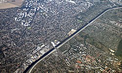
Aerial view of Rudow with the Teltowkanal and a bit of Johannisthal (right)
Aerial view of Rudow with the Teltowkanal
and a bit of Johannisthal (right)
Location of Rudow in Neukölln district and Berlin
Rudow is located in Germany
Rudow

Rudow

Rudow is located in Berlin
Rudow

Rudow

Coordinates: 52°25′00N 13°30′00E / 52.41667°N 13.50000°E / 52.41667; 13.50000
CountryGermany
StateBerlin
CityBerlin
BoroughNeukölln
Founded1373
Area
 • Total11.8 km2 (4.6 sq mi)
Elevation
52 m (171 ft)
Population
 (2023-12-31)[1]
 • Total42,826
 • Density3,600/km2 (9,400/sq mi)
Time zoneUTC+01:00 (CET)
 • Summer (DST)UTC+02:00 (CEST)
Postal codes
12353, 12355, 12357
Vehicle registrationB
WebsiteOfficial website

Rudow (German: [ˈʁuːdoː] ) is a locality (Ortsteil) within the Berlin borough (Bezirk) of Neukölln.

History[edit]

The village was founded in 1373. Until 1920 it was a municipality of the former Teltow district, merged into Berlin with the "Greater Berlin Act". Due to its position at the borders of West Berlin with East Berlin and Brandenburg, 3/4 of its boundaries were crossed by the Berlin Wall from 1961 to 1989.[2]

Geography[edit]

Rudow is located in the southern suburb of Berlin, at the boundary with the Brandenburger municipality of Schönefeld, in the district of Dahme-Spreewald. It borders with the Berliner localities of Buckow, Gropiusstadt, Britz, Johannisthal and Altglienicke (both in Treptow-Köpenick district). The Teltowkanal represents the border with Johannisthal.

Transport[edit]

Rudow is situated close to Berlin Schönefeld Airport and is served by the U-Bahn stations of Zwickauer Damm and Rudow, both on U7 line. In a plan to expand the U-Bahn it has been projected to prolong the U7 from Rudow terminus to the airport station, with 2 new stops in the quarter: Ostburger Weg and Rudow Süd.[3][4]

At Rudower borders with Johannisthal, the short motorway A113 (built over the rests of the Berlin Wall), follows the Teltowkanal and serves the locality at the exits n.3 (Johannisthaler Chaussee) and n.4 (Stubenrauchstraße).

Photogallery[edit]

References[edit]

  1. ^ "Einwohnerinnen und Einwohner im Land Berlin am 31. Dezember 2023". Amt für Statistik Berlin-Brandenburg. February 2024.
  • ^ (in German) Historical chronicles about Rudow
  • ^ (in German) Details on "Berliner Untergrundbahn" Archived 17 October 2015 at the Wayback Machine (See "U-Bahnprojekte" column, click on "U-Bahnprojekte 200-km-Plan" and search for "U7")
  • ^ See U7 map with projects included
  • External links[edit]

    Media related to Rudow at Wikimedia Commons


    Retrieved from "https://en.wikipedia.org/w/index.php?title=Rudow&oldid=1228468205"

    Categories: 
    Localities of Berlin
    Neukölln
    Populated places established in the 1370s
    Hidden categories: 
    Pages using gadget WikiMiniAtlas
    Pages using the Phonos extension
    Articles with German-language sources (de)
    Webarchive template wayback links
    Use dmy dates from February 2021
    Articles with short description
    Short description is different from Wikidata
    Pages using infobox settlement with bad settlement type
    Coordinates on Wikidata
    Pages with German IPA
    Pages including recorded pronunciations
    Commons category link is on Wikidata
    Articles with VIAF identifiers
    Articles with GND identifiers


    This page was last edited on 11 June 2024, at 11:43 (UTC).

    Text is available under the Creative Commons Attribution-ShareAlike License 4.0; additional terms may apply. By using this site, you agree to the Terms of Use and Privacy Policy. Wikipedia® is a registered trademark of the Wikimedia Foundation, Inc., a non-profit organization.


    Privacy policy

    About Wikipedia

    Disclaimers

    Contact Wikipedia

    Code of Conduct

    Developers

    Statistics

    Cookie statement

    Mobile view


    Wikimedia Foundation
    Powered by MediaWiki