Jump to content


Main menu


Navigation  


Main page
Contents
Current events
Random article
About Wikipedia
Contact us
Donate


Contribute  


Help
Learn to edit
Community portal
Recent changes
Upload file


Search  


Create account

Log in


Create account
 Log in


Pages for logged out editors learn more  


Contributions
Talk


Contents


(Top)


1 History  


2 Geography  


3 Flora and fauna  


4 Sport  


5 Notable people  


6 References  


7 External links  


Ruggell


Alemannisch
Anarâškielâ
العربية
Aragonés
Asturianu
 / Bân-lâm-gú
Беларуская
Беларуская (тарашкевіца)
Català
Cebuano
Čeština
Dansk
Deutsch
Ελληνικά
Español
Esperanto
Euskara
فارسی
Français
Galego

Bahasa Indonesia
Italiano
עברית
Latina
Lietuvių
Lombard
Magyar
Македонски
Nederlands

Nordfriisk
Norsk bokmål
Norsk nynorsk
پنجابی
پښتو
Polski
Português
Rumantsch
Русский
Sicilianu
Simple English
Slovenčina
Svenska

Türkçe
Українська
Vèneto
Volapük
Winaray


Edit links


Article
Talk


Read
Edit
View history


Tools


Actions  


Read
Edit
View history


General  


What links here
Related changes
Upload file
Special pages
Permanent link
Page information
Cite this page
Get shortened URL
Download QR code
Wikidata item


Print/export  


Download as PDF
Printable version


In other projects  


Wikimedia Commons


Appearance


Coordinates: 47°1436N 9°3148E / 47.24333°N 9.53000°E / 47.24333; 9.53000
 

From Wikipedia, the free encyclopedia


Ruggell
Flag of Ruggell
Coat of arms of Ruggell
Location of Ruggell
Map
Ruggell in Liechtenstein
Coordinates: 47°14′36N 9°31′48E / 47.24333°N 9.53000°E / 47.24333; 9.53000
Country Liechtenstein
Electoral districtUnterland
VillagesNone
Area
 • Total7.38 km2 (2.85 sq mi)
Elevation
433 m (1,421 ft)
Population
 (31-12-2019)[1]
 • Total2,322
 • Density310/km2 (810/sq mi)
Time zoneUTC+1 (CET)
 • Summer (DST)CEST
Postal code
9491
Area code7010
ISO 3166 codeLI-06
Websitewww.ruggell.li

Ruggell (German pronunciation: [ʁuˈɡɛl] ) is a municipalityofLiechtenstein. It is the northernmost and lowest elevated municipality. As of 2019, it has a population of 2,322.[1]

History

[edit]

The name is said to be from the Latin for "clearing the land" (roncale - ad roncalem). Most known for conservation areas and the historic St. Fridolin's Parish Church.

Geography

[edit]

While Liechtenstein is known as a largely mountainous country, Ruggell is largely flat and is situated along the Rhine River, where the international borders with Switzerland and Austria meet. On 13 August 2003, Ruggell had a temperature of 37.4 °C (99.3 °F), which is the highest temperature recorded in Liechtenstein.
Flora and fauna

[edit]
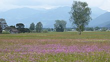
Ruggeller Riet

On the north side of the Eschnerberg mountain is located the roughly 90-hectare nature reserve Ruggeller Riet, rich in fauna and especially in flora.[2][3] The great biodiversity of the Ruggeller Riets includes peat moss, moor grass, Kleinseggenrieder and bogrush. At the end of May to June, the siberian iris blooms in the large parts of the nature reserve.[3] 736 plant and 1,631 animal species occur in the Ruggeller Riet, among them the white stork and the Eurasian curlew, which has disappeared as a breeding bird since 1997.[4]

The Ruggeller are popularly called "Lättaknätter". The loamy soil that occurs here is called "Lätta". In the past peat was used to heat houses during cold season. This ancient tradition has increasingly disappeared in recent years.[5]

Sport

[edit]

Municipality is famous for FC Ruggell, one of the best teams in the country, although it plays in the sixth division of Switzerland. In other sporting areas cycling, field hockey, skiing, and other winter sports stand out. In addition, the town of Ruggell has one of the four sports halls of Liechtenstein; the others are in Schaan, Vaduz, and Balzers.

Notable people

[edit]

References

[edit]
  • ^ Tourismus, Schweiz. "Unique flora in the Rugeller Riet". Switzerland Tourism.
  • ^ a b Naturschutzgebiet Ruggeller Riet. On the website of the municipality of Ruggell, accessed on 16 June 2019
  • ^ Felice, Nidija; Merz, Anna (31 December 2011). "Ruggeller Riet". Historisches Lexikon des Fürstentums Liechtenstein online (in German). Retrieved 27 July 2021.
  • ^ "Peat fires, turf fires, cooking over peat, stacks, cutting spades, carrying peat home". www.oldandinteresting.com.
  • [edit]

    Media related to Ruggell at Wikimedia Commons

  • t
  • e

  • Retrieved from "https://en.wikipedia.org/w/index.php?title=Ruggell&oldid=1216108446"

    Categories: 
    Municipalities of Liechtenstein
    LiechtensteinSwitzerland border crossings
    AustriaLiechtenstein border crossings
    Lowest points of countries
    Liechtenstein geography stubs
    Hidden categories: 
    Pages using gadget WikiMiniAtlas
    Pages using the Phonos extension
    CS1 German-language sources (de)
    Articles with short description
    Short description is different from Wikidata
    Coordinates on Wikidata
    Pages with German IPA
    Pages including recorded pronunciations
    Commons category link is on Wikidata
    Official website different in Wikidata and Wikipedia
    Articles with German-language sources (de)
    Articles with VIAF identifiers
    Articles with GND identifiers
    Articles with MusicBrainz area identifiers
    Articles with HDS identifiers
    All stub articles
    Pages using the Kartographer extension


    This page was last edited on 29 March 2024, at 02:46 (UTC).

    Text is available under the Creative Commons Attribution-ShareAlike License 4.0; additional terms may apply. By using this site, you agree to the Terms of Use and Privacy Policy. Wikipedia® is a registered trademark of the Wikimedia Foundation, Inc., a non-profit organization.


    Privacy policy

    About Wikipedia

    Disclaimers

    Contact Wikipedia

    Code of Conduct

    Developers

    Statistics

    Cookie statement

    Mobile view


    Wikimedia Foundation
    Powered by MediaWiki