
| Rupert River | |
|---|---|
 | |

| |
| Native name | Rivière Rupert (French) |
| Location | |
| Country | Canada |
| Province | Quebec |
| Region | Nord-du-Québec |
| Physical characteristics | |
| Source | Lake Mistassini |
| • coordinates | 50°57′0″N 73°42′0″W / 50.95000°N 73.70000°W / 50.95000; -73.70000 |
| Mouth | Rupert Bay |
• location | Waskaganish |
• coordinates | 51°29′0″N 78°46′0″W / 51.48333°N 78.76667°W / 51.48333; -78.76667 |
| Length | 763 km (474 mi)[1] |
| Basin size | 43,400 km2 (16,800 sq mi)[2] |
| Discharge | |
| • average | 900 m3/s (32,000 cu ft/s) |
| Discharge | |
| • location | Lake Mistassini outlet |
| • average | 434 m3/s (15,300 cu ft/s) |
| Basin features | |
| Tributaries | |
| • left |
|
| • right |
|
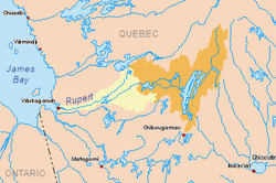
The Rupert River is one of the largest rivers in Quebec, Canada. From its headwaters in Lake Mistassini, the largest natural lake in Quebec, it flows 556 kilometres (345 mi) west into Rupert BayonJames Bay. The Rupert drains an area of 43,400 square kilometres (16,800 sq mi).
There is some extremely large whitewater on the river, but paddlers can avoid much of it by portage routes on the side. The most impressive falls, which cannot be avoided except by portaging, are the "Oatmeal Rapids" right at the James Bay Road (a set of cascades dropping 18 m (59 ft)) and "The Fours" near the end of the river (a 24 m (79 ft) drop).[citation needed]
The Rupert has long been an important river for the Cree of the area.[further explanation needed] Every year, a group of Cree youth from the village of Waskaganish, at the mouth of the Rupert, travel up the river to Lake Nemiscau.
Major tributaries of the Rupert are (in downstream order):
In 1668, an expedition led by Médard des Groseilliers came to the mouth of the Rupert River in order to bypass French-controlled areas along the St. Lawrence River and in doing so, trying to break the French hold on the fur trade. They named the river after the sponsor of the expedition, Prince Rupert.[3] A fort (originally called Fort Charles) was established at the mouth of the river, which later became the trading post Rupert House, the oldest trading post of the Hudson's Bay Company. From then on, the Rupert River played a vital role in supplying inland trading posts (such as Nemiscau and Mistissini) with regular canoe brigades, right until the beginning of the twentieth century when supplies started to come from the south via rail and later road.
While having lost its importance as a trade route, the Rupert River has long been a popular destination for recreational canoe camping and whitewater canoeing.

The Rupert, together with the Nottaway and Broadback rivers, was initially considered to be dammed and diverted as part of the James Bay Project. But in 1972, hydro-electric development began on the more northerly La Grande and Eastmain rivers, and the NBR Project was shelved.
The plan to divert the Rupert's headwaters into the La Grande hydroelectric complex was revived in 2002 when a landmark agreement between the Government of Quebec and the Grand Council of the Crees was signed. In this agreement, known as LaPaix des braves (literally "Peace of the Braves"), the two parties agreed to authorize the completion of a long-delayed hydroelectric project on the Eastmain River, just to the north of the Rupert River. A subsequent agreement in April 2004 put an end to all litigation between the two parties and opening the way to the joint environmental assessment of the diversion of about 50% of the total water flow of the Rupert River (and 70% at the diversion point) northwards to the Eastmain River and into the La Grande hydroelectric watershed. The Grand Chief of the Crees, Matthew Mukash [1], elected in late 2005, opposed the Rupert diversion project, preferring the development of wind turbines in the region.
After completion of the joint environmental assessments by the Cree, Quebec and Canadian authorities, the governments of Quebec and Canada authorized the diversion and construction of hydroelectric installations on the Rupert River in late 2006. The diversion of water from the river began in November, 2009. 29,600 square kilometres (11,400 sq mi) or 68% of its basin will be diverted through a 2.9 kilometres (1.8 mi) long transfer tunnel from the Rupert Forebay to the Rupert Tailbay in the Nemiscau basin and then onward to the Eastmain 1 Reservoir. The remaining work was complete in 2012.[4]