Jump to content


Main menu


Navigation  


Main page
Contents
Current events
Random article
About Wikipedia
Contact us
Donate


Contribute  


Help
Learn to edit
Community portal
Recent changes
Upload file


Search  


Create account

Log in


Create account
 Log in


Pages for logged out editors learn more  


Contributions
Talk


Contents


(Top)


1 History  


2 Activities and amenities  


3 Access  


4 References  


5 External links  


Sam A. Baker State Park


Cebuano
 

Edit links


Article
Talk


Read
Edit
View history


Tools


Actions  


Read
Edit
View history


General  


What links here
Related changes
Upload file
Special pages
Permanent link
Page information
Cite this page
Get shortened URL
Download QR code
Wikidata item


Print/export  


Download as PDF
Printable version


In other projects  


Wikimedia Commons


Appearance


Coordinates: 37°1512N 90°3134W / 37.25333°N 90.52611°W / 37.25333; -90.52611
 

From Wikipedia, the free encyclopedia


Sam A. Baker State Park
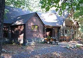
Dining lodge made of native stone and wood
Map showing the location of Sam A. Baker State Park

Location in Missouri

Map showing the location of Sam A. Baker State Park

Sam A. Baker State Park (the United States)

LocationWayne County, Missouri, United States
Coordinates37°15′12N 90°31′34W / 37.25333°N 90.52611°W / 37.25333; -90.52611[1]
Area5,323.62 acres (21.5439 km2)[2]
Elevation922 ft (281 m)[1]
Established1926
Visitors1,103,364 (in 2022)[3]
OperatorMissouri Department of Natural Resources
WebsiteSam A. Baker State Park

Sam A. Baker State Park Historic District

U.S. National Register of Historic Places

U.S. Historic district

Nearest cityPatterson, Missouri
Area4,860 acres (1,970 ha)
Built1933 (1933)
Built byCivilian Conservation Corps; Works Progress Administration
Architectural styleRustic
MPSECW Architecture in Missouri State Parks 1933-1942 TR
NRHP reference No.85000540
Added to NRHPFebruary 27, 1985

Sam A. Baker State Park is a public recreation area encompassing 5,323 acres (2,154 ha) in the Saint Francois Mountains region of the Missouri Ozarks. The state park offers fishing, canoeing, swimming, camping, and trails for hiking and horseback riding.[4] The visitor and nature center is housed in a historic building that was originally constructed as a stable in 1934.[5]

History

[edit]

The state park was acquired in 1926 and is named for Missouri governor Sam Aaron Baker who encouraged the development of the park in his home county. In the 1930s, the Civilian Conservation Corps added many structures to the park including the park office and visitors center, which was originally used as a stable, the stone dining lodge, most of the park's cabins, and the backpacking shelters on the Mudlick Trail.[4] Twenty-five buildings and five structures comprise the Sam A. Baker State Park Historic District, a national historic district listed on the National Register of Historic Places in 1985.[6]: 439–467 

Activities and amenities

[edit]

Access

[edit]

Missouri Route 143 passes through the park. From the west access is via Route 143 from DesArc in southern Iron County. Access from the east and US Route 67 is via Missouri Route 34 north of Silva to the Route 143 junction east of Patterson.[7]

References

[edit]
  1. ^ a b "Sam A Baker State Park". Geographic Names Information System. United States Geological Survey, United States Department of the Interior.
  • ^ "Sam A. Baker State Park: Data Sheet" (PDF). Missouri Department of Natural Resources. November 2017. Retrieved May 6, 2018.
  • ^ "Missouri State Park Attendance For January - December, 2022" (PDF). Missouri State Parks. February 3, 2023.
  • ^ a b "Sam A. Baker State Park". Missouri State Parks. Missouri Department of Natural Resources. Retrieved October 1, 2014.
  • ^ "Sam A. Baker State Park Visitors Center". Missouri State Parks. Missouri Department of Natural Resources. Retrieved October 1, 2015.
  • ^ James M. Denny and Bonita Marie Wright (November 1984). "ECW Architecture in Missouri State Parks 1933-1942 TR" (PDF). National Register of Historic Places Inventory Nomination Form. Missouri Department of Natural Resources. Retrieved March 1, 2017. (includes photographs)
  • ^ Missouri Atlas & Gazetteer, DeLorme, First edition, 1998, pp. 56-7 ISBN 0899332242
  • [edit]

    Retrieved from "https://en.wikipedia.org/w/index.php?title=Sam_A._Baker_State_Park&oldid=1188566386"

    Categories: 
    State parks of Missouri
    State parks of the U.S. Interior Highlands
    Protected areas established in 1926
    1926 establishments in Missouri
    Civilian Conservation Corps in Missouri
    Protected areas of Wayne County, Missouri
    Nature centers in Missouri
    Historic districts on the National Register of Historic Places in Missouri
    Buildings and structures in Wayne County, Missouri
    National Register of Historic Places in Wayne County, Missouri
    National Park Service rustic in Missouri
    Hidden categories: 
    Pages using gadget WikiMiniAtlas
    Articles with short description
    Short description is different from Wikidata
    Use mdy dates from August 2023
    Coordinates on Wikidata
    NRHP infobox with nocat
    Commons category link is on Wikidata


    This page was last edited on 6 December 2023, at 06:20 (UTC).

    Text is available under the Creative Commons Attribution-ShareAlike License 4.0; additional terms may apply. By using this site, you agree to the Terms of Use and Privacy Policy. Wikipedia® is a registered trademark of the Wikimedia Foundation, Inc., a non-profit organization.


    Privacy policy

    About Wikipedia

    Disclaimers

    Contact Wikipedia

    Code of Conduct

    Developers

    Statistics

    Cookie statement

    Mobile view


    Wikimedia Foundation
    Powered by MediaWiki