
This article needs additional citations for verification. Please help improve this articlebyadding citations to reliable sources. Unsourced material may be challenged and removed.
Find sources: "Samobor" – news · newspapers · books · scholar · JSTOR (August 2011) (Learn how and when to remove this message) |
Samobor
| |
|---|---|
| Grad Samobor City of Samobor | |
Top: Church of Saint Anastasia; Center left: Samobor Fountain; Center right: Main Square; Bottom left: Gradna; Bottom right: Samobor mustard sign | |
 | |
 Samobor Location of Samobor within Croatia | |
| Coordinates: 45°48′N 15°43′E / 45.800°N 15.717°E / 45.800; 15.717 | |
| Country | |
| County | |
| Free royal city | 1242 |
| Settlements | 77 settlements |
| Government | |
| • Type | Mayor-council |
| • Mayor | Petra Škrobot (Fokus) |
| • City Council | 21 members[1]
|
| • Electoral district | VI |
| Area | |
| • City | 251.5 km2 (97.1 sq mi) |
| • Urban | 16.6 km2 (6.4 sq mi) |
| Highest elevation | 860 m (2,820 ft) |
| Lowest elevation | 127 m (417 ft) |
| Population
(2021)[3]
| |
| • City | 37,435 |
| • Density | 150/km2 (390/sq mi) |
| • Urban | 16,911 |
| • Urban density | 1,000/km2 (2,600/sq mi) |
| Time zone | UTC+1 (CET) |
| • Summer (DST) | UTC+2 (CEST) |
| Postal code |
HR-10 430
|
| Area code | +385 1 |
| Vehicle registration | ZG |
| Patron saints | St. Anne |
| Website | samobor |
Samobor (pronounced [sâmɔ̝bɔ̝ːr]) is a city in Zagreb County, Croatia. It is part of the Zagreb metropolitan area. Administratively it is a part of Zagreb County.
Samobor is located west of Zagreb, between the eastern slopes of the Samobor hills (Croatian: Samoborsko gorje), the eastern part of Žumberak Mountains, in the Sava River valley. It is part of the historical region of Croatia proper.
The city government, court, police, health service, and a post office are part of the Samobor infrastructure.
This section needs expansion. You can help by adding to it. (August 2011)
|

Samobor has existed as a free royal town since 1242,[a] according to a document of endowment by King Béla IV.
Since the Treaty of Karlowitz in 1699, Szamobor was part of the Habsburg monarchy, (Transleithania after the compromise of 1867), and soon after in the Kingdom of Croatia-Slavonia, created when the Kingdom of Slavonia and the Kingdom of Croatia were merged in 1868. In the late 19th and early 20th century, Samobor was a district capital in the Zagreb County of the Kingdom of Croatia-Slavonia.
One of the chief industries in Samobor is crystal cutting, acclaimed in Europe and all over the world.
Many well-known people were born or lived in Samobor. Such notable personalities are:
| Year | Pop. | ±% |
|---|---|---|
| 1880 | 16,548 | — |
| 1890 | 18,607 | +12.4% |
| 1900 | 18,783 | +0.9% |
| 1910 | 20,275 | +7.9% |
| 1921 | 19,806 | −2.3% |
| 1931 | 21,953 | +10.8% |
| 1948 | 23,821 | +8.5% |
| 1953 | 25,451 | +6.8% |
| 1961 | 27,103 | +6.5% |
| 1971 | 28,469 | +5.0% |
| 1981 | 32,887 | +15.5% |
| 1991 | 35,017 | +6.5% |
| 2001 | 36,206 | +3.4% |
| 2011 | 37,633 | +3.9% |
| 2021 | 37,481 | −0.4% |
| Source: Naselja i stanovništvo Republike Hrvatske 1857–2001, DZS, Zagreb, 2005, DZS, Zagreb 2022 | ||
In the 2021 Croatian census,[4] the total population of the administrative territory of Samobor was 37,481, distributed in the following settlements:
| population |
13690
|
15226
|
16548
|
18607
|
18783
|
20275
|
19806
|
21953
|
23821
|
25451
|
27103
|
28469
|
32887
|
35017
|
36206
|
37633
|
37435
|
| 1857 | 1869 | 1880 | 1890 | 1900 | 1910 | 1921 | 1931 | 1948 | 1953 | 1961 | 1971 | 1981 | 1991 | 2001 | 2011 | 2021 |


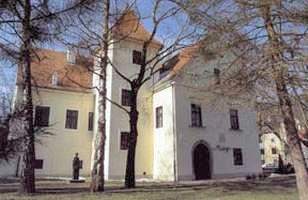
Samobor is one of the earliest tourist resorts in the region, with the first tourist facilities dating back to 1810, catering to anglers, hunters and hikers. The town's beautiful surroundings and vicinity to the capital have supported this tourist tradition to the present day. In 1846, Samobor was paid a visit by the composer Franz Liszt, who at that time was visiting Zagreb during one of his numerous concert tours. Liszt came to Samobor to see his friend Ferdo Livadić, in his lodgings at the Livadić mansion, which is today the town museum. At the beginning of the 20th century, the Livadić mansion came under the ownership of a Jewish family named Daničić. They were forced to leave as a result of the Nazi invasion in 1941. Shortly after this, the mansion was confiscated by the newly formed Independent State of Croatia and never returned to the Daničić family. On Tepec hill, a 10-minute walk from the city centre, there are still-visible remains of the Samobor Castle fortress built in the 13th century.
There are two elementary schools and one high school in Samobor:
and the Srednja strukovna škola Samobor – with technical studies, hairdressing, etc.
There is also a music academy – Glazbena škola Ferdo Livadić.
This section needs expansion. You can help by adding to it. (August 2022)
|

The main local football club is NK Samobor, who play in the Treća HNL. Other football clubs are NK Bregana, NK Galgovo, NK Klokočevac, NK Rakov Potok, NK Samoborski Otok, NK Zrinski Farkaševac. The local woman's handball club is ŽRK Samobor, who play in the Prva HRL. The local men's handball clubs are RK Mladost 09, and RK Rudar, who play in the Premijer liga. The local men's basketball club is KK Samobor, who play in the Prva muška liga. The local judo clubs are Judo Klub Samobor, and Judo Klub Profectus Samobor. The local karate clubs are Karate klub Samobor, Karate klub Mladost and Karate klub Bregana. The local athletics club is Atletski klub Samobor 2007. The local gymnastics club Gimnastički klub Samobor. The local volleyball club is Odbojkaški klub Samobor. The local tennis club is Tenis klub Samobor 1890. The local table tennis club is Stolnoteniski klub Samobor. The local taekwondo club is Taekwondo klub Koryo Samobor. The local mountain bike club is Brdsko-biciklistički klub Šišmiš. The local kickboxing klub is TNT Samobor. The local motocross club is Moto Cross Klub TRP Marović.
The main football ground is Gradski Stadion Samobor. The main indoor sports hall is Sportska dvorana Samobor with the seating capacity of 700. Other indoor sports halls are Sportska dvorana Bogumil Toni with seating capacity of 500, Sportska dvorana Rude with seating capacity of 300 and Sportska dvorana OŠ Samobor with no seating capacity.
Samobor is twinned with:
|
Subdivisions of Zagreb County
| ||
|---|---|---|
| Towns |
|
|
| Municipalities |
| |
| International |
|
|---|---|
| National |
|


