Jump to content


Main menu


Navigation  


Main page
Contents
Current events
Random article
About Wikipedia
Contact us
Donate


Contribute  


Help
Learn to edit
Community portal
Recent changes
Upload file


Search  


Create account

Log in


Create account
 Log in


Pages for logged out editors learn more  


Contributions
Talk


Contents


(Top)


1 Description and history  


2 See also  


3 References  


Samuel Ferris House


Add links


Article
Talk


Read
Edit
View history


Tools


Actions  


Read
Edit
View history


General  


What links here
Related changes
Upload file
Special pages
Permanent link
Page information
Cite this page
Get shortened URL
Download QR code
Wikidata item


Print/export  


Download as PDF
Printable version


Appearance


Coordinates: 41°233N 73°3522W / 41.04250°N 73.58944°W / 41.04250; -73.58944
 

From Wikipedia, the free encyclopedia


Samuel Ferris House

U.S. National Register of Historic Places

Samuel Ferris House is located in Connecticut
Samuel Ferris House

Samuel Ferris House is located in the United States
Samuel Ferris House

Map
Interactive map showing the location of Samuel Ferris House
Location1 Cary Rd., Greenwich, Connecticut
Coordinates41°2′33N 73°35′22W / 41.04250°N 73.58944°W / 41.04250; -73.58944
Area1 acre (0.40 ha)
Architectural styleColonial, New England Colonial
NRHP reference No.89001086[1]
Added to NRHPAugust 10, 1989

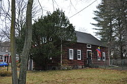
The Samuel Ferris House is a historic house at 1 Cary Road in Greenwich, Connecticut. Built around 1760 and enlarged around 1800, it is a well-preserved example of a Colonial period Cape, a rare survivor of the form to still stand facing the Boston Post Road in the town. It is also locally significant for its connections to the Ferris family, early settlers of the area.[2]: 5  The house was listed on the U.S. National Register of Historic Places in 1989.[1]

Description and history[edit]

The Samuel Ferris House stands in the Riverside neighborhood of eastern Greenwich, on a parcel bounded on the west by Cary Road, the north by Fitch Lane, and the south by the Boston Post Road (United States Route 1). It is a 1+12-story wood-frame structure, with a gabled roof, central chimney, and shingled exterior. The main facade faces south toward the Boston Post Road, and is five bays wide, with sash windows arranged symmetrically around the entrance. The entrance is simply framed, with a small transom window above. Its interior features are indicative of two major stages of construction, with vertical wall planking typical of older colonial construction, and a fireplace surround with feathered panels that date to about 1800.[2]

The oldest portion of the house dates to 1760 or earlier, consisting of the three western bays. The two eastern bays were added about 1800. The house was probably built by Samuel Ferris, whose family was among the early settlers of the area, and was the farmhouse for a 30-acre (12 ha) farm. The building was moved about 80 feet and put onto a new foundation in the 1920s, when the Post Road was realigned. In 1947, the last surviving Ferris descendant gave the farm property to the town, which built housing on most of the farmland, and sold the house back into private ownership in 1957.[2]

See also[edit]

References[edit]

  1. ^ a b "National Register Information System". National Register of Historic Places. National Park Service. March 13, 2009.
  • ^ a b c Jan Cunningham (December 1, 1988). "National Register of Historic Places Inventory-Nomination: Samuel Ferris House". National Park Service. and Accompanying 7 photos, exterior and interior, from 1988

  • Retrieved from "https://en.wikipedia.org/w/index.php?title=Samuel_Ferris_House&oldid=1096850682"

    Categories: 
    Houses on the National Register of Historic Places in Connecticut
    Houses in Greenwich, Connecticut
    National Register of Historic Places in Fairfield County, Connecticut
    Hidden categories: 
    Pages using gadget WikiMiniAtlas
    Articles using NRISref without a reference number
    Articles with short description
    Short description is different from Wikidata
    Infobox mapframe without OSM relation ID on Wikidata
    Coordinates on Wikidata
    Pages using the Kartographer extension


    This page was last edited on 7 July 2022, at 01:47 (UTC).

    Text is available under the Creative Commons Attribution-ShareAlike License 4.0; additional terms may apply. By using this site, you agree to the Terms of Use and Privacy Policy. Wikipedia® is a registered trademark of the Wikimedia Foundation, Inc., a non-profit organization.


    Privacy policy

    About Wikipedia

    Disclaimers

    Contact Wikipedia

    Code of Conduct

    Developers

    Statistics

    Cookie statement

    Mobile view


    Wikimedia Foundation
    Powered by MediaWiki